State Geological Map at Scale 1
State Geological Map at Scale 1
State Geological Map at Scale 1

You also want an ePaper? Increase the reach of your titles
YUMPU automatically turns print PDFs into web optimized ePapers that Google loves.
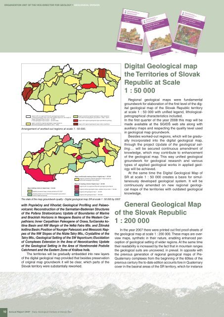
ORGANIZATION UNIT OF THE VICE-DIRECTOR FOR GEOLOGY * GEOLOGICAL DIVISIONregions with non-approved them<strong>at</strong>ic geological groundworkor without geological maps (only with upd<strong>at</strong>ed regions for the needs ofDigital <strong>Geological</strong> <strong>Map</strong> <strong>at</strong> scale 1 : 50 000),or with geological map <strong>at</strong> scale 1 : 25 000 solelyregion covered by regional geological maps issued ondeformed topographic groundwork (1973 – 1992)Arrangement of worked-out regions <strong>at</strong> scale 1 : 50 000.<strong>Map</strong>s meeting criteria of digital map 1 : 50 000digitally processed maps, already printed-out till 2007already printed-out non-deformed topographic groundwork,without digital processingregion covered by regional geological maps issued onnon-deformed topographic groundwork (1992 – 2007)region with regional geological maps submitted for printingregion with regional geological maps under compil<strong>at</strong>ion<strong>Map</strong>s conditionally meeting criteria of digital map 1 : 50 000regions covered by regional geological maps issued ondeformed topographic groundwork<strong>Map</strong>s not meeting criteria of digital map 1 : 50 000regions with non-approved them<strong>at</strong>ic geological groundworkregions without geological maps, upd<strong>at</strong>ed only <strong>at</strong> scale 1 : 50 000regions with geological map 1 : 25 000regions with geological map 1 : 200 000The st<strong>at</strong>e of the map groundwork quality - Digital geological map SR <strong>at</strong> scale 1 : 50 000 by 2007.with Popriečny and Vihorl<strong>at</strong>; <strong>Geological</strong> Profiling and PalaeovolcanicReconstruction of the Sarm<strong>at</strong>ian-Badenian Structuresof the Poľana Str<strong>at</strong>ovolcano; Upd<strong>at</strong>e of Boundaries of Marineand Brackish Horizons in Neogene Basins of the Western Carp<strong>at</strong>hians;Inner Carp<strong>at</strong>hian Paleogene of Orava, Turčianska kotlinaBasin and NW Margin of the Veľká F<strong>at</strong>ra Mts. and Žilinskákotlina Basin; Position of Younger Paleozoic and Mesozoic Nappesof the NW Slopes of the Nízke T<strong>at</strong>ry Mts.; Crystalline of theT<strong>at</strong>ry Mts.; <strong>Geological</strong> Setting of the SW Veporicum; Elucid<strong>at</strong>ionof Complexes Extension in the Area of Neovolcanites; Upd<strong>at</strong>eof the <strong>Geological</strong> Setting in the Area of Horehronské PodolieC<strong>at</strong>chment and the Eastern Zone of Kráľova hoľa.The territories will be gradually embedded into new layersof the digital geological map provided th<strong>at</strong> besides preserv<strong>at</strong>ionof original map groundwork it will be clear, which parts of theSlovak territory were substantially reworked.Digital <strong>Geological</strong> mapthe Territories of SlovakRepublic <strong>at</strong> <strong>Scale</strong>1 : 50 000Regional geological maps were fundamentalgroundwork for elabor<strong>at</strong>ion of the fi rst level of the digitalgeological map of the Slovak Republic territory<strong>at</strong> scale 1 : 50 000 with unified legend, lithologicalpetrographicalcharacteristics included.In the fi rst quarter of the year 2008 this map will bemade available <strong>at</strong> the SGIDŠ web site along withauxiliary maps and respecting the quality level usedin geological map groundwork.Besides worked-out regions, which will be graduallyincorpor<strong>at</strong>ed into the digital geological map,through the project Upd<strong>at</strong>e of the geological setting....will be secured continuous amendment ofknowledge, which may contribute to enhancementof the geological map. This way unified geologicalgroundwork for geological research and varioustypes of applied geological works in applied geologywill be achieved.At the same time the Digital <strong>Geological</strong> <strong>Map</strong> ofSR <strong>at</strong> scale 1 : 50 000 cre<strong>at</strong>es a basis for simultaneouslydeveloped geological system. It will becontinuously amended on new regional geologicalmaps of the territories with outd<strong>at</strong>ed geologicalknowledge.General <strong>Geological</strong> <strong>Map</strong>of the Slovak Republic1 : 200 000In the year 2007 there were printed out first proof-sheets ofthe geological map <strong>at</strong> scale 1 : 200 000. These maps are overviewmaps, synthetic in their n<strong>at</strong>ure, enabling enhanced perceptionof geological setting of wider regions. At the same timetheir readability is increased by the fact th<strong>at</strong> in mountain rangesthe geological suits are uncovered, in prevail. In opposite withthe previous gener<strong>at</strong>ion of regional geological maps of Pre-Qu<strong>at</strong>ernary complexes from the beginning of the 60ties of theprevious century the to-d<strong>at</strong>e edition accounts fore in Qu<strong>at</strong>ernarycover in the basinal areas of the SR territory, which for instance10 Annual Report 2007 <strong>St<strong>at</strong>e</strong> <strong>Geological</strong> Institute of Dionýz Štúr