State Geological Map at Scale 1
State Geological Map at Scale 1
State Geological Map at Scale 1

You also want an ePaper? Increase the reach of your titles
YUMPU automatically turns print PDFs into web optimized ePapers that Google loves.
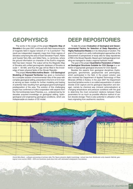
ORGANIZATION UNIT OF THE VICE-DIRECTOR FOR GEOLOGY * GEOLOGICAL DIVISIONGEOPHYSICSThe works in the scope of the project Magnetic <strong>Map</strong> ofSlovakia in the year 2007 continued with field measurementsof magnetic field in regular network of 1 to 3 points/km 2 . Theresult are independent magnetic maps from three regions ofSlovakia comprising the area of East-Slovakian Flysch, Nízkeand Vysoké T<strong>at</strong>ry Mts. and Veľká F<strong>at</strong>ra, i.e. territories, wherethe ground inform<strong>at</strong>ion on character of the Earth‘s magneticfield has been missed. The output will be the Magnetic <strong>Map</strong>of Slovakia with unified geomagnetic d<strong>at</strong>abase of Slovakia <strong>at</strong>scale 1 : 50 000, and thus the gap will be filled in the knowledgeof basic physical fields of the Slovak Republic.The project Horná Nitra kotlina Basin – 3-D <strong>Geological</strong>Modeling of Exposed Territories has given a momentumfor a complex solution of environmental risks of the area withcomplex geological setting, presented in the form of 3-D modelserving as basic module for further modeling and testingof potential risks resulting from geological-geomorphologicalpredisposition of the area. The solution of this challengingproject has confirmed a fruitful cooper<strong>at</strong>ion with experts fromthe Hornonitrianske bane Prievidza, a.s., underpinned by fordecades acquired knowledge on geological setting, hydrogeologicaland engineering geological conditions, which areindispensable <strong>at</strong> cre<strong>at</strong>ion of 3D model.DEEP REPOSITORIESTo-d<strong>at</strong>e the project Evalu<strong>at</strong>ion of <strong>Geological</strong> and GeoenvironmentalFactors for Selection of Deep Repository ofHighly Radioactive Wastes is in its initial phase of solution. Thegoal of the project is to verify methodological approaches <strong>at</strong> theassessment of perspectives of study sites for deep repositoriesof RW in the Slovak Republic. Based upon hydrogeological modelingwe managed to cre<strong>at</strong>e a regional hydraulic model.The goal of the project Quantit<strong>at</strong>ive Parameters of Selected<strong>Geological</strong> Structures Suitable for CO2 Storage is a selectionof appropri<strong>at</strong>e geological structures for CO2 deposit.Besides the experts from geological disciplines (hydrogeologists,geochemists, geophysicists and petrologists),which particip<strong>at</strong>ed in the field, in the project solution wasalso involved the Department of Applied Technology of RawMinerals (ATNS) in Košice. In the year 2007 the Departmentlaunched tent<strong>at</strong>ive works in so-called sequestr<strong>at</strong>ion of carbondioxide (CO2 capture and its geological deposition and storage),namely by chemical way (mineral carbon<strong>at</strong>is<strong>at</strong>ion) <strong>at</strong>changing temper<strong>at</strong>ure and pressure conditions with the goalto determine the most convenient rel<strong>at</strong>ions between theseparameters for as much as possible effective method of carbondioxide storage. There is also potential in utilis<strong>at</strong>ion of thehe<strong>at</strong> origin<strong>at</strong>ing from exothermic reactions.Horná Nitra Basin - software processing of primary d<strong>at</strong>a. The Figure presents digital morphology (virtual view from Strážovské vrchy towards Vtáčnik), geologicalcross-section WWS – EEN and boreholes (pale-blue lines with deline<strong>at</strong>ed str<strong>at</strong>igraphic boundaries).<strong>St<strong>at</strong>e</strong> <strong>Geological</strong> Institute of Dionýz Štúr Annual Report 2007 17