VOLUME 1 HUMAN SETTLEMENT PLANNING AND ... - CSIR
VOLUME 1 HUMAN SETTLEMENT PLANNING AND ... - CSIR
VOLUME 1 HUMAN SETTLEMENT PLANNING AND ... - CSIR
- No tags were found...

Create successful ePaper yourself
Turn your PDF publications into a flip-book with our unique Google optimized e-Paper software.
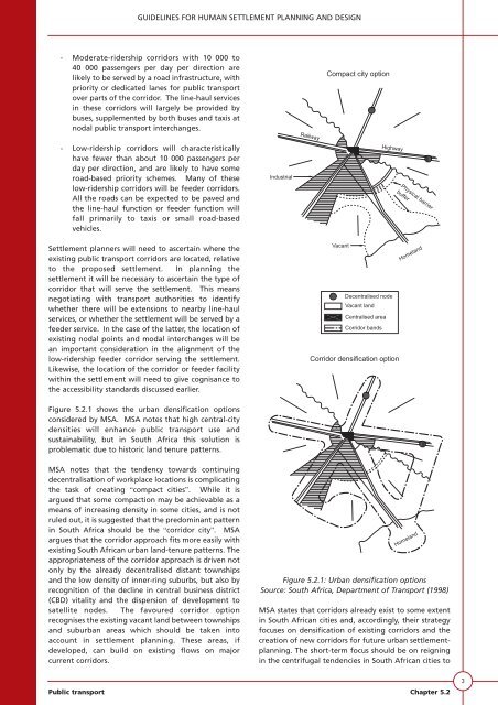
GUIDELINES FOR <strong>HUMAN</strong> <strong>SETTLEMENT</strong> <strong>PLANNING</strong> <strong>AND</strong> DESIGN- Moderate-ridership corridors with 10 000 to40 000 passengers per day per direction arelikely to be served by a road infrastructure, withpriority or dedicated lanes for public transportover parts of the corridor. The line-haul servicesin these corridors will largely be provided bybuses, supplemented by both buses and taxis atnodal public transport interchanges.RailwayCompact city option- Low-ridership corridors will characteristicallyhave fewer than about 10 000 passengers perday per direction, and are likely to have someroad-based priority schemes. Many of theselow-ridership corridors will be feeder corridors.All the roads can be expected to be paved andthe line-haul function or feeder function willfall primarily to taxis or small road-basedvehicles.Settlement planners will need to ascertain where theexisting public transport corridors are located, relativeto the proposed settlement. In planning thesettlement it will be necessary to ascertain the type ofcorridor that will serve the settlement. This meansnegotiating with transport authorities to identifywhether there will be extensions to nearby line-haulservices, or whether the settlement will be served by afeeder service. In the case of the latter, the location ofexisting nodal points and modal interchanges will bean important consideration in the alignment of thelow-ridership feeder corridor serving the settlement.Likewise, the location of the corridor or feeder facilitywithin the settlement will need to give cognisance tothe accessibility standards discussed earlier.Figure 5.2.1 shows the urban densification optionsconsidered by MSA. MSA notes that high central-citydensities will enhance public transport use andsustainability, but in South Africa this solution isproblematic due to historic land tenure patterns.IndustrialHighwayVacantDecentralised nodeVacant landCentralised areaCorridor bandsCorridor densification optionPhysical barrierbufferHomelandMSA notes that the tendency towards continuingdecentralisation of workplace locations is complicatingthe task of creating “compact cities”. While it isargued that some compaction may be achievable as ameans of increasing density in some cities, and is notruled out, it is suggested that the predominant patternin South Africa should be the “corridor city”. MSAargues that the corridor approach fits more easily withexisting South African urban land-tenure patterns. Theappropriateness of the corridor approach is driven notonly by the already decentralised distant townshipsand the low density of inner-ring suburbs, but also byrecognition of the decline in central business district(CBD) vitality and the dispersion of development tosatellite nodes. The favoured corridor optionrecognises the existing vacant land between townshipsand suburban areas which should be taken intoaccount in settlement planning. These areas, ifdeveloped, can build on existing flows on majorcurrent corridors.HomelandFigure 5.2.1: Urban densification optionsSource: South Africa, Department of Transport (1998)MSA states that corridors already exist to some extentin South African cities and, accordingly, their strategyfocuses on densification of existing corridors and thecreation of new corridors for future urban settlementplanning.The short-term focus should be on reigningin the centrifugal tendencies in South African cities toPublic transport Chapter 5.23