Create successful ePaper yourself
Turn your PDF publications into a flip-book with our unique Google optimized e-Paper software.
P LAN IG LO BII TERRESTRIS ..<br />
Mappa Vniverfalis<br />
Utricinip He sai itp/icerium Orient or Occidentals relievers...um<br />
mar", General bur, llaaiva,e, ceasy4sta tt actlAlt,<br />
cettrei Ittntif:;e4ariit 44?tata a<br />
AltH.T.W.r17<br />
.1 44. ..V.r./144 4r44. It ./641,414,44,4re<br />
.1444. ,4 !I' 1,44 Ml le, re. 4.4..4.4or<br />
gg.t..ra .44 4.1.4.004<br />
S<br />
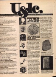
Large map above shows the<br />
Eastern and Western Hemi-<br />
spheres and was compiled<br />
from other maps drawn by<br />
Homann, 1746. Smaller<br />
map directly above is a revi-<br />
sion done by Homann<br />
in 1784.<br />
esi#:<br />
arms.,,...<br />
1693, at the time the map was produced, indicate that the<br />
Nuremberg council questioned -who had commissioned<br />
Johann's map even though he did get paid for making<br />
changes to the copper printing plate for the Nuremberg<br />
map, and received eight gulden for his efforts—which was<br />
probably a sizable amount in that day.<br />
Homann's work in Nuremberg as an engraver<br />
of map printing plates was interrupted abruptly. The edict<br />
of the city council questioning his map assignment cast<br />
suspicion on his integrity.<br />
He was arrested once, wavered between his<br />
Lutheran and Catholic faith and secretly left his wife and<br />
child in Nuremberg in 1693 to become a Dominican in<br />
Vienna. For the next several years, Homann led an unstable,<br />
wandering life.<br />
During this period of personal turbulence, Johann<br />
completed his first detailed work in map etching. From<br />
mid...1696 to late 1697, he produced 34 individual maps for<br />
Christoph Cellarius' "Notitia Orbis Antiqui," and fol ,<br />
lowed that with a major part of the maps used in Heinrich<br />
Scherer's "Atlas Novus ...Augsburg, 170347to:'<br />
Homann also prepared copper plates for maps in<br />
Heinrich Ursinus' "Arboretum Biblicum... Nuremberg,<br />
1699'; and provided etchings for a book on calligraphy and<br />
the art of maps by Jakob Sandrart and David Funck in<br />
the same period.<br />
The great Dutch publishing houses dominated<br />
the map market internationally during the 16th and first<br />
1"<br />
MAYPE.— MONDE,<br />
qui reprefente le d.eaix He mifpheres fa voir<br />
ethei Oriesst a .ylsti dr l'Ocrailetrt tiree de/<br />
yeowttrt CAW, gersef-alee Ate./ra ..Pnyikee.e. Ilallue<br />
joar Lorite , et 1.4.4 ■Vei p... f. .4'tritier,<br />
:Ago fel,eti .<br />
-4, 4"- ,z<br />
half of the 17th century. Political conditions in the world<br />
then presented obstacles which slowed progress in economic<br />
and scientific development, but cartography, as most other<br />
sciences at the close of the 17th century, stumbled forward<br />
nevertheless.<br />
Progress in cartography and map technology was<br />
being made, but slowly. An atlas of French national territory<br />
was published in 1619, and the same French publisher<br />
later produced a medium-scale map of France itself.<br />
The latter work's hydrography was quite detailed,<br />
but the map's relief detail was poorly presented. However,<br />
the map went through four editions and remained the stark ,<br />
dard of the day until it was outdated as a result of the work<br />
of an Italian astronomer, Giovannni Domenico Cassini<br />
(1625-1712).<br />
Real progress in cartography began with the work<br />
of Nicola Sanson and his three sons. A man of wide inter ,<br />
ests, including studies of science and antiquities, Sanson<br />
had been influenced by the French mathematician and<br />
philosopher Rene Descartes, who believed in the personals<br />
ity of mathematical exactitude in metaphysical reasoning.<br />
Sanson applied Descartes' approach to mathe ,<br />
matical exactitude in his own work, and is known as the<br />
inventor of the sinusoidal projection — a way of illustrating a<br />
map so that it projects the entire surface of the earth with<br />
all parallels as straight lines evenly spaced, the central meridian<br />
as one half the length of the equator and all other<br />
meridians as curved lines.<br />
19