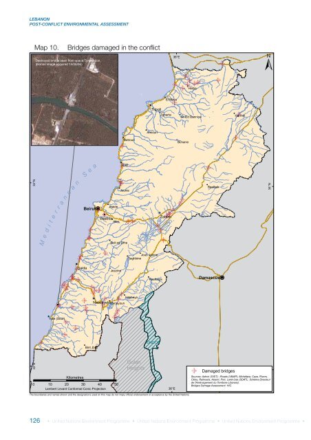
LEBANONPOST-CONFLICT ENVIRONMENTAL ASSESSMENTMap 10.Bridges damaged in the conflictDestroyed bridge seen from space,Tyre region.(Ikonos image acquired 14/08/06).36°EHalbaEl MinieTripoliZghartaSir Ed DanniyeHermelAmiounBatrounBcharreS e aJbeil34°Nr a n ea nBeirutJdaideJounieBaalbek34°Nt e rM e d iBaabdaAleyBeit ed DineZahlehJoub JanineSaghbineSaidaJezzineRachaiyaDamascusNabatiyeh MarjayounHasbeyaTyre (Sour)Bint JbeilUNDOF33°NGolanHeightsDamaged bridges33°NKilometres0 10 20 30 40 50Lambert Levant Conformal Conic Projection36°ESources: Admin (GIST) ; Roads (VMAP); Mohafaza, Caza, Rivers,Cities, Railroads, Airport, Port, Land-Use (SDATL: Schéma Directeurde l'Aménagement du Territoire Libanais).Bridges Damage <strong>Assessment</strong>: HIC.The boundaries and names shown and the designations used on this map do not imply official endorsement or acceptance by the United Nations.126 • United Nations Environment Programme • United Nations Environment Programme • United Nations Environment Programme •
WATER RESOURCESThe analysis of a water sample taken near theQasmieh causeway show that only coppermarginally exceeds the environmental screeningcriteria. However, the <strong>UNEP</strong> team observed thatthe main Qasmieh temporary bypass bridge (onthe lower Litani) was constructed directly on theriverbed. Although culverts have been installed,the deck of the bridge should be raised abovethe riverbed so as not to impede water flow.Poor and hasty construction could also lead tolocalized erosion problems. Guidelines on bestpractice in bridge reconstruction and dismantlingof temporary structures should be provided tomitigate impacts on river ecology.Other structural damage includes the destructionof irrigation and off-take canals, which hasreportedly led to water losses and underminedthe operation of irrigation systems, particularly inTaibe in South <strong>Lebanon</strong>, where a major projectwas underway to irrigate 15,000 ha of land.GroundwaterThe aforementioned caveat regarding theprecipitation regime and the fact that thesampling was conducted during the dry seasonis equally valid when considering the potentialimpact of the 2006 conflict on groundwaterquality. Although intermittent rainfall did occurin late September and October, the risk of surfacecontaminant percolation to the water table withinthis short time frame, particularly given its depth(50 - 300 m), is low. In total, <strong>UNEP</strong> collected 20groundwater samples in the Greater Beirut area, inSouth <strong>Lebanon</strong>, and the Beqaa. The groundwaterquality analysis that was performed can providethe necessary baseline for future monitoringwork.As noted earlier, <strong>Lebanon</strong>’s hydrogeology isdominated by karst, whose unique qualities make itparticularly vulnerable to pollution. Its high sensitivityresults from limited pollutant filtration due to largefractures and high flow rates in the preferentialflow paths of karst conduits. In consequence, selfpurificationand biodegradation can be significantlyreduced. Besides the Beqaa and Al-Assi River valley,and the narrow coastal zone including Beirut, whererelatively shallow unconfined aquifers predominate,the country can generally be classified as karstic. Inareas of through-flow karst, flushing is quite rapidand flows ultimately discharge into the sea, includingvia submarine springs. In other areas of diffuse flowand isolated karst, the flushing of contaminants isa slower process, which may result in a longer-termproblem.The first rains occurred in mid-October 2006,causing the first flush of both conflict fallout andunrelated contaminants into the groundwater.Given <strong>Lebanon</strong>’s karstic hydrogeology characterizedby relatively short residence times, it is expectedthat the contaminants could reach the groundwaterwithin the next few months. Follow-up samplingto gauge evolving groundwater quality conditionsover time should therefore ideally start in Januaryor February 2007. The aquifers most vulnerable toconflict-related pollution are considered to be theLower Cretaceous and Middle Coastal Cretaceousof Mount <strong>Lebanon</strong>, and the Middle CretaceousWestern basin in South <strong>Lebanon</strong>. The latter is oneof the largest aquifers in the country.The water quality analysis found significantchronic biological and pathogenic contaminationof <strong>Lebanon</strong>’s groundwater. All tested samplesbut one indicate the presence of faecal coliform.Three samples had faecal coliform greater than1,000/100 ml, representing a very high level ofcontamination and risk. Three other samplesfrom groundwater sources used for domestic nondrinkingpurposes had a faecal coliform count of260 - 700, representing an unacceptably highly risk.A quarter of the samples had intermediate faecalcoliform counts of 10 - 100, and nearly half wereconsidered to present a low risk. The high levels offaecal coliform are almost certainly due to impropersewage and wastewater disposal. In addition, nitrateconcentrations were above the natural range innearly half of the samples examined. Likely sourcesfor elevated levels of nitrate are agricultural run-offand sewage. Finally, approximately half the samplesalso show a pH below the range for natural waters(< 6.5), which could also be an indication oforganic contamination.The main chemical pollutants detected ingroundwater are heavy metals. The most widelydistributed are zinc and nickel, which exceed theirenvironmental screening criteria in close to threequartersof the analysed samples. However, only thetwo samples taken at the Jiyeh power plant (1,173ug/l) and Transmed (921 ug/l) in Beirut registered• United Nations Environment Programme • United Nations Environment Programme • United Nations Environment Programme •127