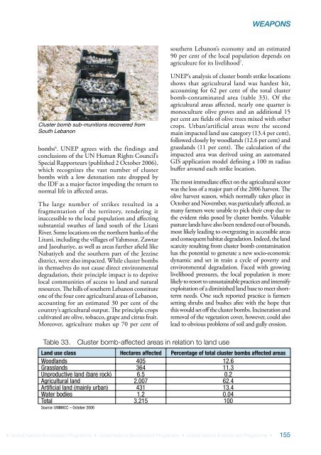
LEBANONPOST-CONFLICT ENVIRONMENTAL ASSESSMENTLong-term impacts ofweapons-related contaminationThe smear samples taken from a numberof locations show elevated levels of heavymetals. In some cases, these originatedfrom the source of the explosion (i.e. thebombs themselves), and in other cases fromthe targets. In addition to the residents whosuffered physical harm in the bombings, awider section of the population may thereforehave been exposed to heavy metal pollutionresulting from the pollutant cloud generatedby the bombing. Many of these heavy metalshave short- and long-term health impacts,including carcinogenicity, and their potentialeffects should be tracked and treated.It is recommended that a national registry ofpeople living in close proximity to major bombtargets be established, and that their healthbe tracked in the long term to allow earlyidentification of unusual health trends, suchas cancer, and adequate support measuresto be implemented.Other weapons<strong>UNEP</strong> was able to observe unexploded ammunitionor parts of most of the weapon systems thatUNMACC and Mine Action Group (MAG)experts reported as having been used during theconflict. These munitions were seen either duringsite visits, or at the UNMACC and MAG centres,as well as at the two Lebanese Army ExplosiveOrdnance Disposal (EOD) centres in Nabatiyehand Marjayoun. The team studied hundreds ofobjects and pictures and remained in close contactwith MAG EOD experts.All the remnants of weapons found during theperiod of the assessment – including those atthe two Lebanese Army EOD centres – wereidentified as weapons of well-known design.Site-specific health and environmentalconcernsIn a number of villages and towns – includingBint Jbeil, Arnoun, Nabatiyeh and Kaffrah – thelocal population informed the <strong>UNEP</strong> team thatinhabitants had suffered from headaches and skinirritations for a period of time after the attacks andthat a bad odour had prevailed. Residents weretherefore concerned that weapons with a potentiallong-term environmental impact had been used.In some places, such as Arnoun and Nabatiyeh,residents were able to show the team the exact impactsite that caused these effects. <strong>UNEP</strong> investigated thecraters in question and identified the weapons usedas Mark 80-type bombs, particularly the Mark 84(known as a ‘free-fall’ bomb). Indeed, a variety ofMark 84 bomb residue was collected at the sites.This type of bomb is not fully efficient in explosion,and causes surface contamination by unexplodedmaterial or impact dust. Dust contamination canresult in a bad, ‘chemical’ smell, usually provokingheadaches and skin irritations. However, theseeffects are not permanent, as the unexplodedmaterial degrades naturally within a few days.<strong>UNEP</strong> did not find any cause for environmentalconcern relating to weapons used at the sitesinvestigated in the above-mentioned locations.Cluster bombs<strong>UNEP</strong> encountered cluster bombs throughoutits survey of southern <strong>Lebanon</strong>. Although exactstatistics regarding the number of cluster bombsused in <strong>Lebanon</strong> are not available, there could beup to one million unexploded cluster bomblets inSouth <strong>Lebanon</strong> according to UNMACC reports 4 .Most cluster bombs were delivered by rockets orartillery, with a limited number (BLU-63-typebombs) apparently dropped by aircraft.By 13 November 2006 5 , with approximately 85 percent of southern <strong>Lebanon</strong> assessed, 813 cluster bombstrike locations had been identified, covering an areaof 3,271 ha or 32.7 km². However, uncertaintyremains about the exact location of bombs. Foreach cluster bomb strike, clearance personnel mustcheck an area totaling 196,000 m² to locate (andeventually destroy) all unexploded bomblets. Bythe end of November 2006, more than 58,000bomblets had been cleared and destroyed jointly byUNMACC (and contractors), UNIFIL engineersand the Lebanese Armed Forces, but it is estimatedthat 12 to 15 months will be necessary to clear allcluster bomblets from the region.Between the end of the conflict and 11 November,136 people were injured and 23 killed by cluster154 • United Nations Environment Programme • United Nations Environment Programme • United Nations Environment Programme •
WEAPONSsouthern <strong>Lebanon</strong>’s economy and an estimated90 per cent of the local population depends onagriculture for its livelihood 7 .Cluster bomb sub-munitions recovered fromSouth <strong>Lebanon</strong>bombs 6 . <strong>UNEP</strong> agrees with the findings andconclusions of the UN Human Rights Council’sSpecial Rapporteurs (published 2 October 2006),which recognizes the vast number of clusterbombs with a low detonation rate dropped bythe IDF as a major factor impeding the return tonormal life in affected areas.The large number of strikes resulted in afragmentation of the territory, rendering itinaccessible to the local population and affectingsubstantial swathes of land south of the LitaniRiver. Some locations on the northern banks of theLitani, including the villages of Yahmour, Zawtarand Jaouhariye, as well as areas further afield likeNabatiyeh and the southern part of the Jezzinedistrict, were also impacted. While cluster bombsin themselves do not cause direct environmentaldegradation, their principle impact is to deprivelocal communities of access to land and naturalresources. The hills of southern <strong>Lebanon</strong> constituteone of the four core agricultural areas of <strong>Lebanon</strong>,accounting for an estimated 30 per cent of thecountry’s agricultural output. The principle cropscultivated are olive, tobacco, grape and citrus fruit.Moreover, agriculture makes up 70 per cent of<strong>UNEP</strong>’s analysis of cluster bomb strike locationsshows that agricultural land was hardest hit,accounting for 62 per cent of the total clusterbomb-contaminated area (table 33). Of theagricultural areas affected, nearly one quarter ismonoculture olive groves and an additional 15per cent are fields of olive trees mixed with othercrops. Urban/artificial areas were the secondmain impacted land use category (13.4 per cent),followed closely by woodlands (12.6 per cent) andgrasslands (11 per cent). The calculation of theimpacted area was derived using an automatedGIS application model defining a 100 m radiusbuffer around each strike location.The most immediate effect on the agricultural sectorwas the loss of a major part of the 2006 harvest. Theolive harvest season, which normally takes place inOctober and November, was particularly affected, asmany farmers were unable to pick their crop due tothe evident risks posed by cluster bombs. Valuablepasture lands have also been rendered out of bounds,most likely leading to overgrazing in accessible areasand consequent habitat degradation. Indeed, the landscarcity resulting from cluster bomb contaminationhas the potential to generate a new socio-economicdynamic and set in train a cycle of poverty andenvironmental degradation. Faced with growinglivelihood pressures, the local population is morelikely to resort to unsustainable practices and intensifyexploitation of a diminished land base to meet shorttermneeds. One such reported practice is farmerssetting shrubs and bushes afire with the hope thatthis would set off the cluster bombs. Incineration andremoval of the vegetation cover, however, could alsolead to obvious problems of soil and gully erosion.Table 33.Cluster bomb-affected areas in relation to land useLand use class Hectares affected Percentage of total cluster bombs affected areasWoodlands 405 12.6Grasslands 364 11.3Unproductive land (bare rock) 6.5 0.2Agricultural land 2,007 62.4Artificial land (mainly urban) 431 13.4Water bodies 1.2 0.04Total 3,215 100Source: UNMACC – October 2006• United Nations Environment Programme • United Nations Environment Programme • United Nations Environment Programme •155