Stafford Road Corridor Area Action Plan
Stafford Road Corridor Area Action Plan
Stafford Road Corridor Area Action Plan

You also want an ePaper? Increase the reach of your titles
YUMPU automatically turns print PDFs into web optimized ePapers that Google loves.
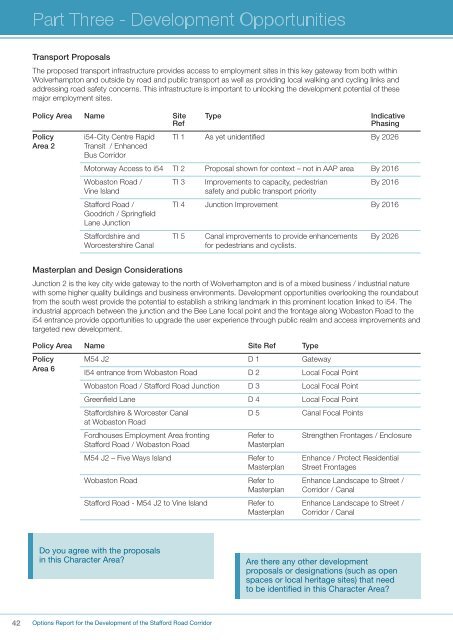
Transport ProposalsThe proposed transport infrastructure provides access to employment sites in this key gateway from both withinWolverhampton and outside by road and public transport as well as providing local walking and cycling links andaddressing road safety concerns. This infrastructure is important to unlocking the development potential of thesemajor employment sites.Policy <strong>Area</strong> Name Site Type IndicativeRefPhasingPolicy i54-City Centre Rapid TI 1 As yet unidentified By 2026<strong>Area</strong> 2 Transit / EnhancedBus <strong>Corridor</strong>Motorway Access to i54 TI 2 Proposal shown for context – not in AAP area By 2016Wobaston <strong>Road</strong> / TI 3 Improvements to capacity, pedestrian By 2016Vine Islandsafety and public transport priority<strong>Stafford</strong> <strong>Road</strong> / TI 4 Junction Improvement By 2016Goodrich / SpringfieldLane Junction<strong>Stafford</strong>shire and TI 5 Canal improvements to provide enhancements By 2026Worcestershire Canalfor pedestrians and cyclists.Masterplan and Design ConsiderationsJunction 2 is the key city wide gateway to the north of Wolverhampton and is of a mixed business / industrial naturewith some higher quality buildings and business environments. Development opportunities overlooking the roundaboutfrom the south west provide the potential to establish a striking landmark in this prominent location linked to i54. Theindustrial approach between the junction and the Bee Lane focal point and the frontage along Wobaston <strong>Road</strong> to thei54 entrance provide opportunities to upgrade the user experience through public realm and access improvements andtargeted new development.Policy <strong>Area</strong> Name Site Ref TypePolicy M54 J2 D 1 Gateway<strong>Area</strong> 6I54 entrance from Wobaston <strong>Road</strong> D 2 Local Focal PointWobaston <strong>Road</strong> / <strong>Stafford</strong> <strong>Road</strong> Junction D 3 Local Focal PointGreenfield Lane D 4 Local Focal Point<strong>Stafford</strong>shire & Worcester Canal D 5 Canal Focal Pointsat Wobaston <strong>Road</strong>Fordhouses Employment <strong>Area</strong> fronting Refer to Strengthen Frontages / Enclosure<strong>Stafford</strong> <strong>Road</strong> / Wobaston <strong>Road</strong>MasterplanM54 J2 – Five Ways Island Refer to Enhance / Protect ResidentialMasterplan Street FrontagesWobaston <strong>Road</strong> Refer to Enhance Landscape to Street /Masterplan <strong>Corridor</strong> / Canal<strong>Stafford</strong> <strong>Road</strong> - M54 J2 to Vine Island Refer to Enhance Landscape to Street /Masterplan <strong>Corridor</strong> / CanalDo you agree with the proposalsin this Character <strong>Area</strong>?Are there any other developmentproposals or designations (such as openspaces or local heritage sites) that needto be identified in this Character <strong>Area</strong>?42Options Report for the Development of the <strong>Stafford</strong> <strong>Road</strong> <strong>Corridor</strong>