Stafford Road Corridor Area Action Plan
Stafford Road Corridor Area Action Plan
Stafford Road Corridor Area Action Plan

You also want an ePaper? Increase the reach of your titles
YUMPU automatically turns print PDFs into web optimized ePapers that Google loves.
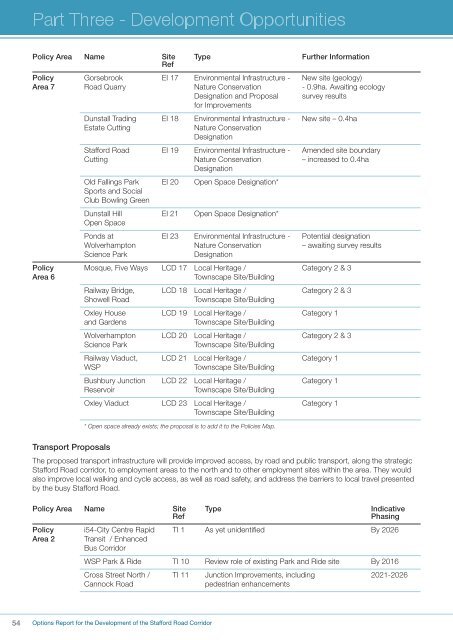
Policy <strong>Area</strong> Name Site Type Further InformationRefPolicy Gorsebrook EI 17 Environmental Infrastructure - New site (geology)<strong>Area</strong> 7 <strong>Road</strong> Quarry Nature Conservation - 0.9ha. Awaiting ecologyDesignation and Proposal survey resultsfor ImprovementsDunstall Trading EI 18 Environmental Infrastructure - New site – 0.4haEstate CuttingNature ConservationDesignation<strong>Stafford</strong> <strong>Road</strong> EI 19 Environmental Infrastructure - Amended site boundaryCutting Nature Conservation – increased to 0.4haDesignationOld Fallings Park EI 20 Open Space Designation*Sports and SocialClub Bowling GreenDunstall Hill EI 21 Open Space Designation*Open SpacePonds at EI 23 Environmental Infrastructure - Potential designationWolverhampton Nature Conservation – awaiting survey resultsScience ParkDesignationPolicy Mosque, Five Ways LCD 17 Local Heritage / Category 2 & 3<strong>Area</strong> 6Townscape Site/BuildingRailway Bridge, LCD 18 Local Heritage / Category 2 & 3Showell <strong>Road</strong>Townscape Site/BuildingOxley House LCD 19 Local Heritage / Category 1and GardensTownscape Site/BuildingWolverhampton LCD 20 Local Heritage / Category 2 & 3Science ParkTownscape Site/BuildingRailway Viaduct, LCD 21 Local Heritage / Category 1WSPTownscape Site/BuildingBushbury Junction LCD 22 Local Heritage / Category 1ReservoirTownscape Site/BuildingOxley Viaduct LCD 23 Local Heritage / Category 1Townscape Site/Building* Open space already exists; the proposal is to add it to the Policies Map.Transport ProposalsThe proposed transport infrastructure will provide improved access, by road and public transport, along the strategic<strong>Stafford</strong> <strong>Road</strong> corridor, to employment areas to the north and to other employment sites within the area. They wouldalso improve local walking and cycle access, as well as road safety, and address the barriers to local travel presentedby the busy <strong>Stafford</strong> <strong>Road</strong>.Policy <strong>Area</strong> Name Site Type IndicativeRefPhasingPolicy i54-City Centre Rapid TI 1 As yet unidentified By 2026<strong>Area</strong> 2 Transit / EnhancedBus <strong>Corridor</strong>WSP Park & Ride TI 10 Review role of existing Park and Ride site By 2016Cross Street North / TI 11 Junction Improvements, including 2021-2026Cannock <strong>Road</strong>pedestrian enhancements54Options Report for the Development of the <strong>Stafford</strong> <strong>Road</strong> <strong>Corridor</strong>