- Page 3: City of Kendleton20‐Year Growth P
- Page 7: Kendleton 20-Year Growth PlanTable
- Page 10 and 11: Section 1.0 IntroductionThe city’
- Page 12 and 13: Section 1.0 Introduction1.3 Accepta
- Page 14 and 15: Section 2.0 Vision and GoalsTable 2
- Page 16 and 17: Section 2.0 Vision and GoalsMembers
- Page 18 and 19: This page left intentionally blank.
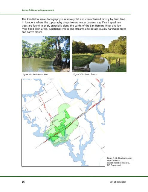
- Page 20 and 21: Section 3.0 Community AssessmentUlt
- Page 22 and 23: Section 3.0 Community AssessmentFro
- Page 26 and 27: Section 3.0 Community Assessment3.3
- Page 28 and 29: Section 3.0 Community AssessmentLin
- Page 30 and 31: Section 4.0 Land UseAs shown on the
- Page 32 and 33: Section 4.0 Land UseSuch tracts are
- Page 34: This page left intentionally blank.
- Page 39 and 40: Section 5.0 TransportationThe I-69
- Page 41 and 42: Section 5.0 TransportationArterial
- Page 43 and 44: Section 5.0 TransportationTable 5-A
- Page 45 and 46: Section 5.0 Transportation5.4 Pedes
- Page 47: This page left intentionally blank.
- Page 50 and 51: Section 6.0 HousingSeveral windshie
- Page 52 and 53: Section6.0 Housing6.3 Housing Assis
- Page 54 and 55: Section 7.0 Economic DevelopmentApa
- Page 56 and 57: Section 7.0 Economic DevelopmentFig
- Page 58 and 59: Section 7.0 Economic DevelopmentTab
- Page 60 and 61: Section 7.0 Economic Development7.6
- Page 62 and 63: Section 7.0 Economic Development7.7
- Page 64 and 65: Section 8.0 Utilities8.2 Future Uti
- Page 66 and 67: Section 9.0 Parks and RecreationThe
- Page 68 and 69: Section 9.0 Parks and Recreation9.3
- Page 70 and 71: Section 10.0 Community ResourcesFig
- Page 72 and 73: This page left intentionally blank.
- Page 74 and 75:
Section 11.0 Recommendationsbut wil
- Page 76 and 77:
Section 11.0 Recommendations11.2 Wi
- Page 79:
KENDLETON COMMUNITY ASSESSMENT, 201
- Page 83 and 84:
EXECUTIVE SUMMARYBackgroundLocated
- Page 85:
Domestic water supply and waste wat
- Page 88 and 89:
population of 496, 3 though a posit
- Page 90 and 91:
Population by AgeThe age distributi
- Page 93 and 94:
INCOMEPer Capita IncomePer capita p
- Page 95:
$10,413,675* and ranked 9th in the
- Page 98 and 99:
Figure 11: Map of KendletonSource:
- Page 100 and 101:
CS Traditional Funded $159,068.97 2
- Page 102 and 103:
RailThe Kansas City Southern Railwa
- Page 104 and 105:
Figure 10 - Annual Rail Tons, East
- Page 107 and 108:
EDUCATION AND WORKFORCEEducationPri
- Page 109 and 110:
Recent district achievements includ
- Page 111 and 112:
College EducationThe University of
- Page 113 and 114:
WorkforceTrends in employment are u
- Page 115 and 116:
United Parcel Service 924 Thermo Pr
- Page 117 and 118:
Business and FinancialOperations Oc
- Page 119 and 120:
Employment by IndustryThe employmen
- Page 121 and 122:
However, as demonstrated below, For
- Page 123:
Figure 27: Fort Bend County Labor F
- Page 126 and 127:
Houston Community Bank, NationalAss
- Page 128 and 129:
SWOT AnalysisTEEX employees have cr
- Page 130 and 131:
on‐site hemodialysis suite allowi
- Page 132 and 133:
• Karateo Blue Tiger Martial Arts
- Page 134 and 135:
o Fort Bend County Courthouse• Th
- Page 137 and 138:
Appendix B: Public Involvement Comm
- Page 139 and 140:
Breakout session notes as transcrib
- Page 141 and 142:
Appendix C. Population Estimate and
- Page 143 and 144:
a. Population Forecast Based on RAZ
- Page 145 and 146:
Figure C-3. Zip Code 77417Table C-D
- Page 147 and 148:
Table C-E. 2010-2035 Forecasts: Zip