

GEOmedia_3_2016 special issue for INTERGEO

Create successful ePaper yourself
Turn your PDF publications into a flip-book with our unique Google optimized e-Paper software.
<strong>INTERGEO</strong><br />
of what is known from<br />
the restitution of photos<br />
and the subsequent study<br />
and post-processing; they<br />
provide in<strong>for</strong>mation relating<br />
to the amount of material removed<br />
and, finally, they are the<br />
only possible solution to reach<br />
critical areas that may only be<br />
known with the conventional<br />
aerial photogrammetry systems<br />
and with inevitable higher costs.<br />
"In order to plan the operation<br />
we referred to a regional technical<br />
map (CTR) - continues<br />
Santiccioli - and we decided<br />
to set a fixed altitude of 130<br />
meters. Through some control<br />
points on the ground we made<br />
12 strips with an overlap of 70<br />
percent between each photo,<br />
acquiring one frame every 25<br />
meters. We got a 3D model of<br />
the quarry, a cloud of points,<br />
the DTM and DSM from the<br />
restitution and we processed all<br />
the photogrammetric data with<br />
a <strong>special</strong> software characterized<br />
by a very high level of metric<br />
accuracy. We can say that this<br />
result satisfied the client and<br />
FlyTop, that realized the work."<br />
The application of the UAV<br />
technology has grown significantly<br />
also <strong>for</strong> the cultural heritage<br />
sector, not only <strong>for</strong> monitoring<br />
and documentation,<br />
but e<strong>special</strong>ly <strong>for</strong> the discovery<br />
activities. With the partnership<br />
started between the University<br />
of Salento and FlyTop an<br />
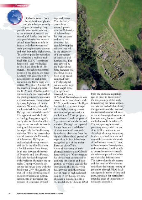
archaeological survey was carried<br />
out in the Veio Park area,<br />
a few kilometers from Rome,<br />
in an area between the towns<br />
of Formello and Isola Farnese.<br />
Gabriele Santiccioli together<br />
with Professor of ancient topography<br />
Giuseppe Ceraudo describes<br />
the survey done with the<br />
fixed wing UAV FlyGeo24Mpx<br />
that led to the identification of<br />
ancient Etruscan and Roman<br />
settlements, in particular the<br />
remains of structures of buildings<br />
and streets.<br />
The discovery<br />
comes from a<br />
research project<br />
that the University<br />
of Salento leads<br />
<strong>for</strong> over ten years<br />
and had a decisive<br />
result last<br />
year following the<br />
mission that led<br />
to the discovery<br />
of a city system<br />
of Etruscan and<br />
Roman eras. The<br />
area covered by<br />
the flight (about<br />
<strong>for</strong>ty hectares) was<br />
overflown with a<br />
fixed-wing drone<br />
equipped with<br />
a 24Mpx digital<br />
camera with single<br />
focal length lens.<br />
The operation<br />
involved the town<br />
of Archi di Pontecchio and was<br />
carried out in compliance with<br />
ENAC specifications. The flight<br />
has enabled to acquire images<br />
of the highest quality, almost<br />
two hundred pictures with a<br />
resolution of 1.7 cm per pixel,<br />
geo-referenced and complete of<br />
3 parameters of translation and<br />
rotation. Through the captured<br />
frames there was a validation<br />
of what were until now only<br />
hypotheses; observing from the<br />
sky the differentiated growth of<br />
vegetation, in fact, it has been<br />
recognized part of the ancient<br />
Etruscan city of Veio.<br />
About the accuracy of aerial<br />
photogrammetric data Gabriele<br />
Santiccioli says: "Our company<br />
has always been committed to<br />
combine innovation and integration,<br />
so we have used all the<br />
instruments that the surveyor<br />
has, arriving until the production<br />
of maps of high technical<br />
quality in few hours. We have<br />
obtained a cloud of points, a<br />
3D model, the DTM and DSM<br />
from the elaborate digital images<br />
in order to know better<br />
the morphology of the land.<br />
Considering the future scenarios,<br />
I do not exclude that shortly<br />
the application of thermal and<br />
multispectral sensors will enter<br />
in the archaeological sector or at<br />
least one study focused on the<br />
result that could be achieved".<br />
The aero-photogrammetric<br />
proximity survey with the use<br />
of an APR represents an archaeological<br />
survey interesting<br />
landscape, as well as a real and<br />
accessible system <strong>for</strong> the study<br />
of preliminary research. Later,<br />
with subsequent investigations<br />
and excavations, it will be able<br />
to determine more accurately<br />
the reference period and other<br />
more detailed in<strong>for</strong>mations.<br />
The survey done in the quarry<br />
and the result of Veio demonstrate<br />
how the remote sensing of<br />
proximity through RPAS is advantageous<br />
in terms of time and<br />
costs, e<strong>special</strong>ly <strong>for</strong> particularly<br />
extended areas of inspection or<br />
not easily accessible.<br />
34 Special Supplement to <strong>GEOmedia</strong> Journal Issue n. 3-<strong>2016</strong>


