

GEOmedia_3_2016 special issue for INTERGEO

Create successful ePaper yourself
Turn your PDF publications into a flip-book with our unique Google optimized e-Paper software.
<strong>INTERGEO</strong><br />
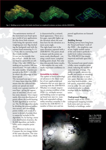
Fig. 3 - Building surveys (such as this family-sized home) are completed in minutes, not hours, with the ZEB-REVO.<br />
The autonomous motion of<br />
the motorised scan head opens<br />
up a world of new applications<br />
<strong>for</strong> this clever little scanner.<br />
Little being the operative word;<br />
weighing just over 4kg (including<br />
the backpack) and with the<br />
scanner head measuring 9 x 11<br />
x 29cm, this is a surveying tool<br />
that is truly mobile.<br />
It’s not just the outside that<br />
has evolved – inside the scanner<br />
head is a powerful yet safe<br />
(Class 1 Eye safe) 100Hz laser –<br />
making an impressive 100 rotations/second.<br />
The unit collects<br />
the same number of points per<br />
second as the ZEB1 – 43,200.<br />
So what’s the advantage of this<br />
faster speed?<br />
The increased scan speed (over<br />
2.5 times faster than the ZEB1)<br />
means that the collected data<br />
points are spread out more<br />
evenly over a greater number of<br />
scan lines - giving the appearance<br />
of smoother, cleaner and<br />
less noisy datasets. More importantly,<br />
this even distribution of<br />
points allows the world-beating<br />
SLAM algorithm to work better.<br />
The SLAM algorithm works<br />
by dividing the scanned surface<br />
into sectors, and identifying<br />
points within each sector. If a<br />
sector is devoid of points, then<br />
it cannot be included in the<br />
algorithm. So, by having a more<br />
even distribution of points, the<br />
SLAM algorithm can build a<br />
fuller, more complete point<br />
cloud.<br />
The difference is clear to see.<br />
Compare the two images below<br />
of the same elevation. The view<br />
on the left is ZEB1 data, which<br />
is characterised by a striated,<br />
lined appearance. There are a<br />
few gaps, e<strong>special</strong>ly higher up<br />
the elevation where the scan<br />
lines have hit the elevation at a<br />
more acute angle.<br />
The right hand view is the<br />
same elevation captured with a<br />
ZEB-REVO. The point cloud<br />
is cleaner and the points are<br />
more evenly distributed – creating<br />
a much more ‘complete’<br />
looking point cloud. Not only<br />
does this provide better results,<br />
it also supplies the user with<br />
vitally important confidence in<br />
the kit.<br />
Versatility in Action<br />
The upshot of these technological<br />
advances is the sheer number<br />
of new applications and<br />
industries that are now open to<br />
scanning with the ZEB-REVO.<br />
Whether it is simply improving<br />
an existing workflow of the<br />
ZEB1 (i.e. stockpile surveys<br />
and building scans) or opening<br />
up brand new uses (i.e. manhole<br />
and suspended ceilings,<br />
utility trenches) versatility is the<br />
word <strong>for</strong> the ZEB-REVO. A<br />
number of these new and improved<br />
applications are featured<br />
below.<br />
Building Surveys<br />
Building surveys have long been<br />
the ‘bread and butter’ work of<br />
the ZEB1 – the simplicity, ease<br />
of use, highly mobile nature<br />
of the unit lends it perfectly to<br />
multi-level, indoor structures.<br />
The ZEB-REVO has simply<br />
improved and built upon this<br />
success.<br />
The increased scan speed creates<br />
a fuller, more complete point<br />
cloud, reducing the number of<br />
areas with low coverage. The<br />
ability to rapidly unscrew the<br />
handle and attach an extending<br />
pole allows the user to reach<br />
into spaces that may not otherwise<br />
have been available – into<br />
loft spaces, suspended ceilings,<br />
even to ‘poke’ the unit out of<br />
windows in order to obtain<br />
overlaps with the building exterior.<br />
Underground Mapping<br />
Another staple of the ZEB1,<br />
underground mapping includes<br />
both mine and cave surveys.<br />
Similarly to buildings, under-<br />
Fig. 4 - The ZEB-RE-<br />
VO in action – handheld,<br />
pole-mounted,<br />
backpack-mounted –<br />
a truly versatile tool.<br />
Special Supplement to <strong>GEOmedia</strong> Journal Issue n°3-<strong>2016</strong> 23


