Rebirth of Water Report 2016-2017
Marsh Creek, which is the largest watershed in greater Saint John, has been the recipient of centuries of untreated municipal wastewater deposition. Offensive odours, unsightly sanitary products and the threat posed by various human pathogens, resulting largely from the ~50 sewage outfalls in the lower reaches of Marsh Creek and the Saint John Harbour, have caused most residents to abandon the wellness of the watercourse. ACAP Saint John, a community-based ENGO and champion of the Harbour Cleanup project, has been conducting water quality monitoring and fish community surveys in the watershed since 1993 with the view towards someday restoring the ecological integrity of this forgotten natural asset.
Marsh Creek, which is the largest watershed in greater Saint John, has been the recipient of centuries of untreated municipal wastewater deposition. Offensive odours, unsightly sanitary products and the threat posed by various human pathogens, resulting largely from the ~50 sewage outfalls in the lower reaches of Marsh Creek and the Saint John Harbour, have caused most residents to abandon the wellness of the watercourse. ACAP Saint John, a community-based ENGO and champion of the Harbour Cleanup project, has been conducting water quality monitoring and fish community surveys in the watershed since 1993 with the view towards someday restoring the ecological integrity of this forgotten natural asset.

Create successful ePaper yourself
Turn your PDF publications into a flip-book with our unique Google optimized e-Paper software.
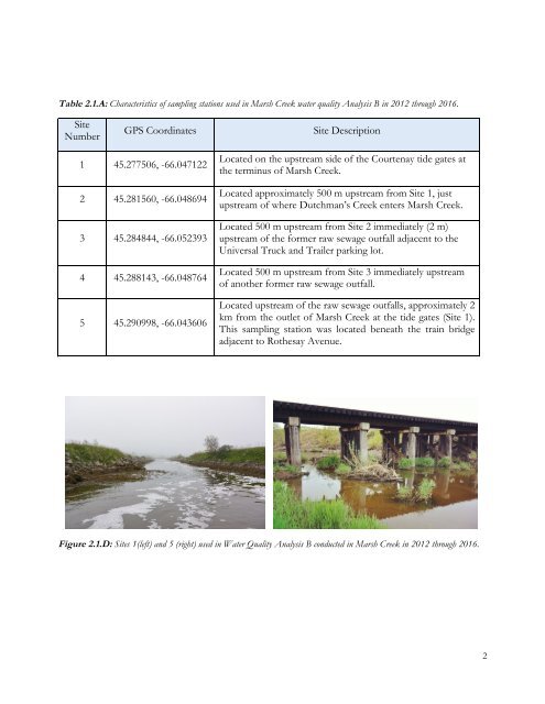
Table 2.1.A: Characteristics <strong>of</strong> sampling stations used in Marsh Creek water quality Analysis B in 2012 through <strong>2016</strong>.<br />
Site<br />
Number<br />
GPS Coordinates<br />
Site Description<br />
1 45.277506, -66.047122<br />
2 45.281560, -66.048694<br />
3 45.284844, -66.052393<br />
4 45.288143, -66.048764<br />
5 45.290998, -66.043606<br />
Located on the upstream side <strong>of</strong> the Courtenay tide gates at<br />
the terminus <strong>of</strong> Marsh Creek.<br />
Located approximately 500 m upstream from Site 1, just<br />
upstream <strong>of</strong> where Dutchman’s Creek enters Marsh Creek.<br />
Located 500 m upstream from Site 2 immediately (2 m)<br />
upstream <strong>of</strong> the former raw sewage outfall adjacent to the<br />
Universal Truck and Trailer parking lot.<br />
Located 500 m upstream from Site 3 immediately upstream<br />
<strong>of</strong> another former raw sewage outfall.<br />
Located upstream <strong>of</strong> the raw sewage outfalls, approximately 2<br />
km from the outlet <strong>of</strong> Marsh Creek at the tide gates (Site 1).<br />
This sampling station was located beneath the train bridge<br />
adjacent to Rothesay Avenue.<br />
Figure 2.1.D: Sites 1(left) and 5 (right) used in <strong>Water</strong> Quality Analysis B conducted in Marsh Creek in 2012 through <strong>2016</strong>.<br />
2