Rebirth of Water Report 2016-2017
Marsh Creek, which is the largest watershed in greater Saint John, has been the recipient of centuries of untreated municipal wastewater deposition. Offensive odours, unsightly sanitary products and the threat posed by various human pathogens, resulting largely from the ~50 sewage outfalls in the lower reaches of Marsh Creek and the Saint John Harbour, have caused most residents to abandon the wellness of the watercourse. ACAP Saint John, a community-based ENGO and champion of the Harbour Cleanup project, has been conducting water quality monitoring and fish community surveys in the watershed since 1993 with the view towards someday restoring the ecological integrity of this forgotten natural asset.
Marsh Creek, which is the largest watershed in greater Saint John, has been the recipient of centuries of untreated municipal wastewater deposition. Offensive odours, unsightly sanitary products and the threat posed by various human pathogens, resulting largely from the ~50 sewage outfalls in the lower reaches of Marsh Creek and the Saint John Harbour, have caused most residents to abandon the wellness of the watercourse. ACAP Saint John, a community-based ENGO and champion of the Harbour Cleanup project, has been conducting water quality monitoring and fish community surveys in the watershed since 1993 with the view towards someday restoring the ecological integrity of this forgotten natural asset.

Create successful ePaper yourself
Turn your PDF publications into a flip-book with our unique Google optimized e-Paper software.
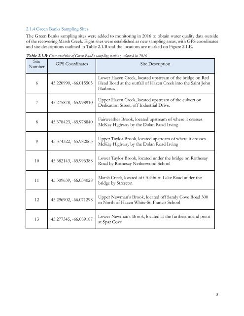
2.1.4 Green Banks Sampling Sites<br />
The Green Banks sampling sites were added to monitoring in <strong>2016</strong> to obtain water quality data outside<br />
<strong>of</strong> the recovering Marsh Creek. Eight sites were established as new sampling areas, with GPS coordinates<br />
and site descriptions outlined in Table 2.1.B and the locations are marked on Figure 2.1.E.<br />
Table 2.1.B: Characteristics <strong>of</strong> Green Banks sampling stations, adopted in <strong>2016</strong>.<br />
Site<br />
GPS Coordinates<br />
Site Description<br />
Number<br />
6 45.220990, -66.015505<br />
7 45.275878, -65.998910<br />
Lower Hazen Creek, located upstream <strong>of</strong> the bridge on Red<br />
Head Road at the outfall <strong>of</strong> Hazen Creek into the Saint John<br />
Harbour.<br />
Upper Hazen Creek, located upstream <strong>of</strong> the culvert on<br />
Dedication Street, <strong>of</strong>f Industrial Drive.<br />
8 45.378423, -65.978840<br />
Fairweather Brook, located upstream <strong>of</strong> where it crosses<br />
McKay Highway by the Dolan Road Irving<br />
9 45.374322, -65.982063<br />
Upper Taylor Brook, located upstream <strong>of</strong> where it crosses<br />
McKay Highway by the Dolan Road Irving<br />
10 45.382143, -65.996388<br />
Lower Taylor Brook, located under the bridge on Rothesay<br />
Road by Rothesay Netherwood School<br />
11 45.309639, -66.034028<br />
Marsh Creek, located <strong>of</strong>f Ashburn Lake Road under the<br />
bridge by Strescon<br />
12 45.296902, -66.071298<br />
Upper Newman’s Brook, located <strong>of</strong>f Sandy Cove Road 300<br />
m North <strong>of</strong> Hazen White-St. Francis School<br />
13 45.277345, -66.089187<br />
Lower Newman’s Brook, located at the furthest inland point<br />
at Spar Cove<br />
3