Rebirth of Water Report 2016-2017
Marsh Creek, which is the largest watershed in greater Saint John, has been the recipient of centuries of untreated municipal wastewater deposition. Offensive odours, unsightly sanitary products and the threat posed by various human pathogens, resulting largely from the ~50 sewage outfalls in the lower reaches of Marsh Creek and the Saint John Harbour, have caused most residents to abandon the wellness of the watercourse. ACAP Saint John, a community-based ENGO and champion of the Harbour Cleanup project, has been conducting water quality monitoring and fish community surveys in the watershed since 1993 with the view towards someday restoring the ecological integrity of this forgotten natural asset.
Marsh Creek, which is the largest watershed in greater Saint John, has been the recipient of centuries of untreated municipal wastewater deposition. Offensive odours, unsightly sanitary products and the threat posed by various human pathogens, resulting largely from the ~50 sewage outfalls in the lower reaches of Marsh Creek and the Saint John Harbour, have caused most residents to abandon the wellness of the watercourse. ACAP Saint John, a community-based ENGO and champion of the Harbour Cleanup project, has been conducting water quality monitoring and fish community surveys in the watershed since 1993 with the view towards someday restoring the ecological integrity of this forgotten natural asset.

Create successful ePaper yourself
Turn your PDF publications into a flip-book with our unique Google optimized e-Paper software.
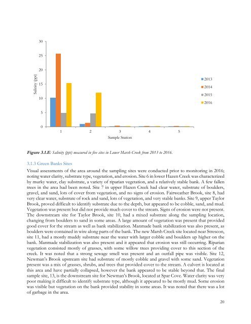
30<br />
25<br />
Salinity (ppt)<br />
20<br />
15<br />
10<br />
5<br />
2013<br />
2014<br />
2015<br />
<strong>2016</strong><br />
0<br />
1 2 3 4 5<br />
Sample Station<br />
Figure 3.1.E: Salinity (ppt) measured in five sites in Lower Marsh Creek from 2013 to <strong>2016</strong>.<br />
3.1.3 Green Banks Sites<br />
Visual assessments <strong>of</strong> the area around the sampling sites were conducted prior to monitoring in <strong>2016</strong>;<br />
noting water clarity, substrate type, vegetation, and erosion. Site 6 in lower Hazen Creek was characterized<br />
by murky water, clay substrate, a variety <strong>of</strong> riparian vegetation, and a relatively stable bank. A few fallen<br />
trees in the area had been noted. Site 7 in upper Hazen Creek had clear water, substrate <strong>of</strong> boulders,<br />
gravel, and sand, lots <strong>of</strong> cover from vegetation, and no signs <strong>of</strong> erosion. Fairweather Brook, site 8, had<br />
very clear water, substrate <strong>of</strong> rock and sand, lots <strong>of</strong> vegetation, and very stable banks. Site 9, upper Taylor<br />
Brook, proved difficult to identify substrate due to the depth, but appeared to be cobble, sand, and mud.<br />
Vegetation was present but did not provide much cover to the stream. Signs <strong>of</strong> erosion were not present.<br />
The downstream site for Taylor Brook, site 10, had a mixed substrate along the sampling location,<br />
changing from boulders to sand in some areas. A large amount <strong>of</strong> vegetation was present that provided<br />
good cover for the stream as well as bank stabilization. Manmade bank stabilization was also present, as<br />
boulders were contained in wire along parts <strong>of</strong> the bank. The new Marsh Creek site located near Strescon,<br />
site 11, had a mostly muddy substrate near the water with larger cobble and boulders up higher on the<br />
bank. Manmade stabilization was also present and it appeared that erosion was still occurring. Riparian<br />
vegetation consisted mostly <strong>of</strong> grasses, with some willow trees providing cover to this section <strong>of</strong> the<br />
creek. It was noted that a strong sewage smell was present and an outfall pipe was visible. Site 12,<br />
Newman’s Brook upstream site had substrate <strong>of</strong> mostly cobble and gravel with some sand. Vegetation<br />
present was a mix <strong>of</strong> grasses, shrubs, and trees that provided cover to the stream. A culvert is located at<br />
this area and have partially collapsed, however the bank appeared to be stable beyond that. The final<br />
sample site, 13, is the downstream site for Newman’s Brook, located at Spar Cove. <strong>Water</strong> clarity was very<br />
poor making it difficult to identify substrate type, although it appeared to be mostly mud. Some erosion<br />
was visible but vegetation on the bank provided stability in some areas. It was noted that there was a lot<br />
<strong>of</strong> garbage in the area.<br />
20