CU1703

You also want an ePaper? Increase the reach of your titles
YUMPU automatically turns print PDFs into web optimized ePapers that Google loves.
SOFTWAREreview<br />
OpenRoads Designer<br />
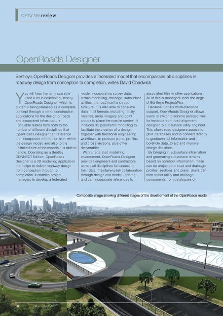
Bentley's OpenRoads Designer provides a federated model that encompasses all disciplines in<br />
roadway design from conception to completion, writes David Chadwick<br />
You will hear the term 'scalable'<br />
used a lot in describing Bentley<br />
OpenRoads Designer, which is<br />
currently being released as a complete<br />
concept through a set of construction<br />
applications for the design of roads<br />
and associated infrastructure.<br />
Scalable relates here both to the<br />
number of different disciplines that<br />
OpenRoads Designer can reference<br />
and incorporate information from within<br />
the design model, and also to the<br />
unlimited size of the models it is able to<br />
handle. Operating as a Bentley<br />
CONNECT Edition, OpenRoads<br />
Designer is a 3D modelling application<br />
that helps to deliver roadway design<br />
from conception through to<br />
completion. It enables project<br />
managers to develop a federated<br />
model incorporating survey data,<br />
terrain modelling, drainage, subsurface<br />
utilities, the road itself and road<br />
furniture. It is also able to consume<br />
data in all formats, including reality<br />
meshes, aerial imagery and point<br />
clouds to place the road in context. It<br />
includes 3D parametric modelling to<br />
facilitate the creation of a design,<br />
together with traditional engineering<br />
workflows, to produce plans, profiles<br />
and cross sections, plus other<br />
deliverables.<br />
With a federated modelling<br />
environment, OpenRoads Designer<br />
provides engineers and contractors<br />
across all disciplines full access to<br />
their data, maintaining full collaboration<br />
through design and model updates,<br />
and can incorporate references to<br />
associated files in other applications.<br />
All of this is managed under the aegis<br />
of Bentley's ProjectWise.<br />
Because it offers multi-discipline<br />
support, OpenRoads Designer allows<br />
users to switch discipline perspectives,<br />
for instance from road alignment<br />
designer to subsurface utility engineer.<br />
This allows road designers access to<br />
gINT databases and to connect directly<br />
to geotechnical information and<br />
borehole data, to aid and improve<br />
design decisions.<br />
By bringing in subsurface information<br />
and generating subsurface terrains<br />
based on borehole information, these<br />
can be projected in road and drainage<br />
profiles, sections and plans. Users can<br />
then select utility and drainage<br />
components from catalogues of<br />
Composite image showing different stages of the development of the OpenRoads model<br />
10<br />
March/April 2017