CU1703

Create successful ePaper yourself
Turn your PDF publications into a flip-book with our unique Google optimized e-Paper software.
CASEstudy<br />
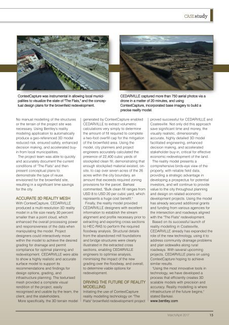
ContextCapture was instrumental in allowing local municipalities<br />
to visualize the state of "The Flats," and the conceptual<br />
design plans for the brownfield redevelopment.<br />
CEDARVILLE captured more than 750 aerial photos via a<br />
drone in a matter of 20 minutes, and using<br />
ContextCapture, incorporated base imagery to build a<br />
precise reality model.<br />
No manual modelling of the structures<br />
or the terrain of the project site was<br />
necessary. Using Bentley's reality<br />
modeling application to automatically<br />
produce a geo-referenced 3D model<br />
reduced risk, ensured safety, enhanced<br />
decision making, and accelerated buyin<br />
from local municipalities.<br />
The project team was able to quickly<br />
and accurately document the current<br />
conditions of "The Flats" and then<br />
present conceptual plans to<br />
demonstrate the type of reuse<br />
envisioned for the brownfield site,<br />
resulting in a significant time savings<br />
for the city.<br />
ACCURATE 3D REALITY MESH<br />
With ContextCapture, CEDARVILLE<br />
produced a multi-resolution 3D reality<br />
model in a file size nearly 30 percent<br />
smaller than a point cloud, which<br />
enhanced the overall processing power<br />
and responsiveness of the data when<br />
manipulating the model. Project<br />
designers could interactively move<br />
within the model to achieve the desired<br />
grading for drainage and permit<br />
compliance for optimal planning and<br />
redevelopment. CEDARVILLE were able<br />
to show a highly realistic and accurate<br />
surface model to support its<br />
recommendations and findings for<br />
design options, grading, and<br />
infrastructure planning. The texturised<br />
mesh provided a complete visual<br />
rendition of the project, easily<br />
recognised and usable by the team, the<br />
client, and the stakeholders.<br />
More specifically, the 3D terrain model<br />
generated by ContextCapture enabled<br />
CEDARVILLE to extract volumetric<br />
calculations very simply to determine<br />
the amount of fill required to complete<br />
a two-foot overfill cap for the mitigation<br />
of the brownfield area. Using the<br />
model, city planners and project<br />
engineers accurately calculated the<br />
presence of 22,400 cubic yards of<br />
stockpiled clean fill, demonstrating that<br />
enough stockpiled material existed, onsite,<br />
to cap over seven acres of the 26<br />
acres within the city boundary, an<br />
amount that exceeds required zoning<br />
provisions for the parcel. Barkasi<br />
commented, "Bulk clean fill ranges from<br />
USD 8 to USD 20 per cubic yard, which<br />
represents a huge cost benefit."<br />
Finally, the reality model provided<br />
CEDARVILLE designers with excellent<br />
information to establish the stream<br />
alignment and profile necessary prior to<br />
extracting and exporting cross sections<br />
to HEC-RAS to perform the required<br />
floodway analysis. Structural details<br />
from the abandoned mill foundations<br />
and bridge structures were clearly<br />
illustrated in the extracted cross<br />
sections, enabling CEDARVILLE<br />
engineers to optimise analysis,<br />
minimising the impact of the new<br />
grading over the floodway, and overall,<br />
to determine viable options for<br />
redevelopment.<br />
DRIVING THE FUTURE OF REALITY<br />
MODELLING<br />
Initiating the use of ContextCapture<br />
reality modelling technology on "The<br />
Flats" brownfield redevelopment project<br />
proved successful for CEDARVILLE and<br />
Coatesville. Not only did this approach<br />
save significant time and money, the<br />
visually realistic, dimensionally<br />
accurate, highly detailed 3D model<br />
facilitated engineering, enhanced<br />
decision making, and accelerated<br />
stakeholder buy-in, critical for effective<br />
economic redevelopment of the land.<br />
The reality model presents a<br />
comprehensive birds-eye view of the<br />
property, with reliable field data,<br />
providing a strategic advantage in<br />
developing a prospectus for potential<br />
investors, and will continue to provide<br />
value to the city throughout planning<br />
and design on related economic<br />
development projects. Using the model<br />
has already secured additional grants<br />
and funding from various agencies for<br />
the intersection and roadways aligned<br />
with the "The Flats" redevelopment.<br />
Based on its successful launch of<br />
reality modelling in Coatesville,<br />
CEDARVILLE already has expanded the<br />
role of the new technology, using it to<br />
address community drainage problems<br />
and plan sidewalks along rural<br />
roadways. With several upcoming<br />
projects, CEDARVILLE plans on using<br />
ContextCapture hoping to achieve<br />
similar results.<br />
"Using the most innovative tools in<br />
technology, we have developed a<br />
process that efficiently creates 3D<br />
scalable models with precision and<br />
accuracy. Reality modelling is where<br />
infrastructure of the future begins,"<br />
stated Barkasi.<br />
www.bentley.com<br />
March/April 2017 15