CU1703

Create successful ePaper yourself
Turn your PDF publications into a flip-book with our unique Google optimized e-Paper software.
SOFTWAREreview<br />
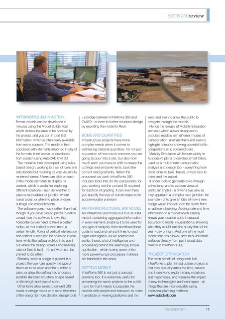
INFRAWORKS 360 IN ACTION<br />
Terrain models can be developed in<br />
minutes using the Model Builder tool,<br />
which defines the area to be covered by<br />
the project, and you can import GIS<br />
information which is often freely available<br />
from many sources. The model is then<br />
populated with elements imported in any of<br />
the formats listed above, or developed<br />
from scratch using AutoCAD Civil 3D<br />
The model is then developed using rulesbased<br />
design, working to a set of rules and<br />
calculations but retaining its very visual fully<br />
rendered format. Users can click on each<br />
of the model elements to display its<br />
context, which is useful for exploring<br />
different solutions - such as whether to<br />
place a roundabout or junction where<br />
roads cross, or where to place bridges,<br />
cuttings and embankments.<br />
The software goes much further than that,<br />
though. If you have picked points to define<br />
a road then the software knows that<br />
horizontal curves need to have a certain<br />
radius, or that vertical curves need a<br />
certain length. Points of vertical intersection<br />
and vertical curves can be adjusted in realtime,<br />
whilst the software chips in to point<br />
out where the design violates engineering<br />
rules or fixes it itself - the software can be<br />
primed to do either.<br />
Similarly, when a bridge is placed in a<br />
project, the user can specify the type of<br />
structure to be used and the number of<br />
piers, or allow the software to choose a<br />
suitable standard structural shape based<br />
on the length and type of span.<br />
Other tools allow users to convert GIS<br />
roads to design roads or to send elements<br />
of the design to more detailed design tools<br />
- a bridge between InfraWorks 360 and<br />
Civil3D - or even to further structural design<br />
by exporting the model to Revit.<br />
BOMS AND QUANTITIES<br />
Infrastructure projects have more<br />
complex needs when it comes to<br />
estimating material quantities. It's not just<br />
a question of how much concrete you are<br />
going to pour into a site, but also how<br />
much earth you have to shift to create the<br />
cuttings and embankments, build the<br />
correct road gradients, flatten the<br />
proposed car park. InfraWorks 360<br />
includes tools that do the calculations for<br />
you, working out the cut and fill required<br />
for each bit of grading. It can even help<br />
you specify the size of culvert required to<br />
accommodate a stream.<br />
AN INFRASTRUCTURAL BIM MODEL<br />
An InfraWorks 360 model is a true 3D BIM<br />
model, containing aggregated information<br />
in every element, enabling it to be used for<br />
any type of analysis, from workflow/labour<br />
costs to road and rail sight lines to road<br />
signs and signals. As we pointed out<br />
earlier, there's a lot of intelligence and<br />
processing behind the seemingly simple<br />
application - which is why some of the<br />
more power-hungry processes it utilises<br />
are handled in the cloud.<br />
GETTING MOBILE<br />
InfraWorks 360 is not just a concept<br />
planning tool. It is extremely useful for<br />
presenting the same projects to the public<br />
- and for that it needs to populate the<br />
models with people and transport, to make<br />
it available on viewing platforms and the<br />
web, and even to allow the public to<br />
navigate through the models.<br />
Hence the release of Mobility Simulation<br />
last year, which allows designers to<br />
populate models with different modes of<br />
transportation, animate them and even to<br />
highlight hotspots showing potential traffic<br />
congestion using coloured bars.<br />
Mobility Simulation will feature widely in<br />
Autodesk's plans to develop Smart Cities,<br />
used as a multi-mode transportation<br />
analysis and design tool - everything from<br />
cycle lanes to taxis, buses, private cars to<br />
trains and the airport.<br />
It offers tools to generate drive-through<br />
animations, and to capture views at<br />
particular angles - a driver’s eye view as<br />
they approach a complex road junction, for<br />
example - or to give an idea of how a new<br />
bridge would impact upon the views from<br />
an adjacent building. Adding date and time<br />
information to a model which already<br />
knows your location adds increased<br />
accuracy to model visualisations, showing<br />
what they would look like at any time of the<br />
year - day or night. And one of the most<br />
recent features allows users to build terrain<br />
surfaces directly from point cloud data<br />
directly in InfraWorks 360.<br />
PROJECT OPTIMISATION<br />
The main benefit of using tools like<br />
InfraWorks to plan infrastructure projects is<br />
that they give all parties the time, means<br />
and incentive to explore many variations,<br />
test hypotheses, and visualise the impact<br />
of new technologies and techniques - all<br />
things that are inconceivable using<br />
traditional planning methods.<br />
www.autodesk.com<br />
March/April 2017 17