CU1703

Create successful ePaper yourself
Turn your PDF publications into a flip-book with our unique Google optimized e-Paper software.
SOFTWAREreview<br />
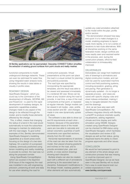
All Bentley applications can be appropriated. Descartes CONNECT Edition simplifies<br />
the extraction of existing ground surfaces from point clouds and reality meshes<br />
functional components to model<br />
underground drainage networks. These<br />
can even be optimised for water flow<br />
using integrated water analysis tools,<br />
showing the results in data tables or<br />
visually in profile views.<br />
ROADWAY DESIGN<br />
OpenRoads Designer - which you<br />
could say is the culmination of the<br />
development of InRoads, GEOPAK, MX<br />
and PowerCivil - is used for the rapid<br />
development of roadway designs. Its<br />
parametric capabilities enables<br />
changes made to any aspect of the<br />
design to be reflected through the<br />
model, and to modify those elements<br />
affected by the change.<br />
This, in effect, means that changing<br />
the radius of a bend in the road would<br />
automatically re-route the subsurface<br />
drainage to maintain its relationship<br />
with the road edges. To give further<br />
examples of this, Bentley demonstrated<br />
OpenRoads Designer's modelling<br />
capabilities at a recent press event,<br />
focusing on the design of a two-lane<br />
highway. On a section of a proposed<br />
roadway, previously positioned using<br />
terrain modelling and reality modelling<br />
to provide its context, the road was run<br />
along the proposed corridor.<br />
Using OpenRoads ConceptStation<br />
(which we covered in the Sept/Oct<br />
2016 issue of the magazine) the road<br />
was modelled in situ with engineering<br />
precision, preserving all work and data<br />
for use when detailing the road for<br />
construction purposes. Virtual<br />
presentations at this point can place<br />
the road in a visual context for planning<br />
and publicity purposes.<br />
The road type was specified by<br />
incorporating the appropriate<br />
templates, and the result was able to<br />
be viewed and assessed immediately<br />
in a rendered 3D view. Slices can be<br />
taken at any location along the road to<br />
provide, in real time, a view of the road<br />
components at that point, or repeated<br />
at regular intervals. Design models can<br />
be viewed in all modes - plan, profile,<br />
cross-section and 3D - and changes<br />
made in one view dynamically update<br />
all views.<br />
The software is also able to show cut<br />
and fill requirements at each slice -<br />
however, because of the parametric<br />
and federated nature of the model<br />
users are now able to calculate and<br />
extract volumetric quantities of earth<br />
movements over specified sections,<br />
directly from the 3D model.<br />
Horizontal representations of sections<br />
of the road can also be taken from the<br />
model, then placed showing gradients<br />
and inclines on the road, and to<br />
provide annotated plan, plan and<br />
profile, or cross section drawings<br />
showing each discipline.<br />
Multiple sheets can also be created,<br />
each with a different set of annotations<br />
pertaining to the associated task or<br />
discipline. Subsequent modifications to<br />
the design model, roadway gradient, or<br />
other elements will also automatically<br />
update any ruled annotation attached<br />
to the model within the plan, profile<br />
and/or section.<br />
The demonstration showed how easy<br />
and quick it is to make changes to a<br />
model, enabling engineers to layout<br />
roads more rapidly, or to run a series of<br />
iterations to test route alternatives. With<br />
all disciplines working on the same<br />
federated model, design conflicts are<br />
more readily seen and resolved earlier<br />
in the process, and, during the<br />
construction phases, office-to-field<br />
collaboration is immeasurably<br />
improved.<br />
DELIVERABLES<br />
Deliverables can range from traditional<br />
sets of drawings to animations and<br />
digital construction models, and can<br />
even be used for automated machine<br />
control and field positioning systems,<br />
including excavation, grading, piling<br />
and paving. Plan generation is<br />
dynamically updated - it's no longer a<br />
separate process - and views are<br />
saved with specific display rules and<br />
sheet indexes embedded, making it<br />
easy to navigate between the model<br />
and the drawings.<br />
And, as we have also seen with<br />
OpenRoads ConceptStation, the<br />
software integrates directly with Bentley<br />
LumenRT to produce cinematic quality<br />
visualisations, adding vegetation,<br />
climate and time display and traffic<br />
simulation using VISSIM. Designs<br />
created using OpenRoads Designer<br />
can be checked for BIM status using<br />
OpenRoads Navigator, which facilitates<br />
the visualisation and review of 3D<br />
designs as well as their status, giving<br />
dispersed teams the ability to check<br />
progress approvals and other issues.<br />
CONCLUSION<br />
We would be hard-pressed to point to<br />
any element of the whole design and<br />
construction process that was missing<br />
or could be improved upon in<br />
OpenRoads Designer, but as we have<br />
seen in the past Bentley will no doubt<br />
find a way to scale beyond even our<br />
wildest expectations in time.<br />
www.bentley.com/openroads<br />
March/April 2017 11