2017 SunCruiser West Coast
West Coast SunCruiser, providing you with safe boating information since 1997.
West Coast SunCruiser, providing you with safe boating information since 1997.

Create successful ePaper yourself
Turn your PDF publications into a flip-book with our unique Google optimized e-Paper software.
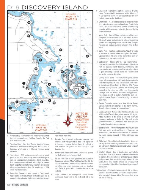
D16 DISCOVERY ISLAND<br />
Continued on<br />
PAGE 122<br />
CHART D17<br />
1. Gonzales Bay – Rocks and reefs. These hazards earned<br />
the bay its original name, Foul Bay. Gonzales Bay Park<br />
is in the west corner.<br />
2. Trafalgar Park – Has King George Viewing Terrace<br />
which was dedicated in 1990 by two Rotary Clubs. It<br />
has signs which point to 14 different locations giving<br />
distances.<br />
3. Trial Islands – A 23 hectare ecological preserve which<br />
protects the most outstanding known assemblage of<br />
rare and endangered plant species in British Columbia.<br />
Four towers are on the islands with a light at Staines<br />
Point. Ships have come to nasty ends here and dozens<br />
of people have lost their lives. 54 people died in 1904<br />
when the Clallam sank.<br />
Continued on<br />
PAGE 119<br />
CHART D15<br />
N<br />
N<br />
4. Enterprise Channel – Also known as Trial Island<br />
Pass; loaded with kelp. Mouat Reef at the east end is<br />
marked and challenging. Only those with local knowledge<br />
should cross here.<br />
20ϒ E. Variation<br />
20ϒ E. Variation<br />
NOT TO BE<br />
USED FOR<br />
NAVIGATION<br />
Use official<br />
Canadian<br />
Hydrographic<br />
Charts<br />
5. Gonzales Point – Named for Gonzalo Lopez de Haro<br />
who was with the Spaniards in their 1790 expedition<br />
of the region. He drew the first charts of the Strait of<br />
Juan de Fuca. The golf course here displays a large<br />
Canadian flag.<br />
6. Harris Island – Lee Rock is south, Emily Island is west.<br />
Tod Rock is north as is Fiddler’s Reef.<br />
7. Oak Bay – An 8 kph (5 mph) speed limit. Be cautious in<br />
the passage between Mary Tod Island and the Oak Bay<br />
Marina breakwater. Willow Beach Park at the north<br />
end offers great views, swimming area and beaches.<br />
Mary Tod Is. is grassy with a small breakwater on the<br />
south tip.<br />
8. Mayor Channel – The passage that coastal vessels<br />
usually use. Tides flood to the north and ebb to the<br />
south.<br />
9. Lewis Reef – Marked by a light on a 6.7 m (22 ft) white<br />
tower. Fiddler’s Reef is also marked with a light on a 7<br />
m (23 ft ) white tower. The passage between the two<br />
reefs is known as the Goal Posts.<br />
10. Chain Islets – A 170 hectare ecological preserve which<br />
also takes in Jemmy Jones Island and Great Chain<br />
Island. It was established to protect bird breeding<br />
grounds, wildflowers and marine life. Carolina Reef is<br />
on the north side.<br />
11. Virtue Rock – East of Chain Islets is one of the most<br />
dangerous areas in the region. At low tide it is under<br />
60 cm of water, just enough to catch unsuspecting<br />
boaters who are gazing across Juan de Fuca. Plumper<br />
Passage can produce currents between three to five<br />
knots.<br />
12. Cattle Point – Has two boat launches. Watch for rocks<br />
at low tide to the east when coming into the launch.<br />
Uplands Park is 75 acres and a tremendous spot for<br />
bird watching. Five knot speed limit.<br />
13. Cadboro Bay – Named after the HBC brigantine Cadboro<br />
and is home to the Royal Victoria Yacht Club. Gyro<br />
Park has beautiful sandy beaches, washrooms, kids<br />
playgrounds, and a great view of the bay where there<br />
is good anchorage. Staines Island and Flower Island<br />
are on the east side of the bay.<br />
14. Jemmy Jones Island – Named after Captain Jemmy<br />
Jones whose experience with boats in the region is<br />
less than inspiring. In 1856 his schooner Emily Parker<br />
burned near Clover Point. In 1858 the Wild Pigeon<br />
capsized leaving Victoria. Carolina, his next ship, ran<br />
aground on the island named for him. This suggests<br />
he might have had either a vision or drinking problem.<br />
Foul ground is north to Cadboro Point and it is an ecological<br />
preserve. Baynes Channel North light is at Cadboro<br />
Point.<br />
15. Baynes Channel – Named after Rear Admiral Robert<br />
Baynes. Currents are stronger in the north channel.<br />
Tides flood to northwest, ebb to southeast.<br />
16. Discovery Island – Named after The Discovery, the ship<br />
which carried Captain George Vancouver to this region.<br />
About two-thirds of the island is a marine park with<br />
temporary anchorage in Rudlin Bay. The north side is<br />
an Indian reserve. At Commodore Point there are lots<br />
of rocks. Heavy tide rips can develop.<br />
17. Sea Bird Point – An American paddle steamer, the Sea<br />
Bird, was on its way from Victoria to Vancouver on<br />
September 7, 1858 when a fire broke out. To save lives<br />
the vessel was run aground. In 1886 a lighthouse was<br />
put up.<br />
18. Alpha Islet – Named for the first ship built in Nanaimo,<br />
the Alpha - a 58 ton trading schooner launched in 1859.<br />
On February 1, 1863 she ran aground with a cargo of<br />
coal in a snowstorm.<br />
19. Chatham Islands – Lots of shoals, rocks and reefs to<br />
worry about. Five radio beacons make the islands easy<br />
to identify. The islands belong to the Songhees Indians<br />
and you need their permission to go ashore. At low<br />
water, these low, wooded islands are almost joined<br />
to one another. Fulford Reef (northeast) is a group of<br />
drying reefs.<br />
20. Haro Strait – The border between the U.S.A. and Canada<br />
runs down the middle. Watch for a counterclockwise<br />
current off the east side of Discovery Island when<br />
the tide is flooding.<br />
120 WEST COAST SUNCRUISER