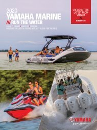
2017 SunCruiser West Coast
West Coast SunCruiser, providing you with safe boating information since 1997.
West Coast SunCruiser, providing you with safe boating information since 1997.

Create successful ePaper yourself
Turn your PDF publications into a flip-book with our unique Google optimized e-Paper software.
N<br />
N<br />
20ϒ E. Variation<br />
20ϒ E. Variation<br />
NOT TO BE<br />
USED FOR<br />
NAVIGATION<br />
Use official<br />
Canadian<br />
Hydrographic<br />
Charts<br />
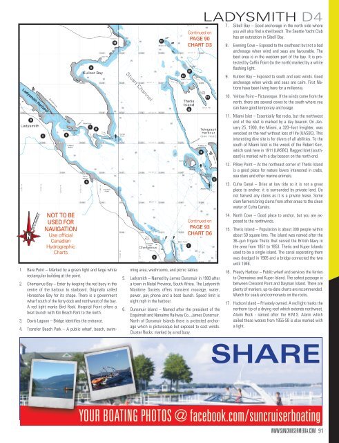
1. Bare Point – Marked by a green light and large white<br />
rectangular building at the point.<br />
2. Chemainus Bay – Enter by keeping the red buoy in the<br />
centre of the harbour to starboard. Originally called<br />
Horseshoe Bay for its shape. There is a government<br />
wharf south of the ferry dock and northwest of the bay.<br />
A red light marks Bird Rock. Hospital Point offers a<br />
boat launch with Kin Beach Park to the north.<br />
3. Davis Lagoon – Bridge identifies the entrance.<br />
4. Transfer Beach Park – A public wharf, beach, swimming<br />
area, washrooms, and picnic tables.<br />
Continued on<br />
PAGE 90<br />
CHART D3<br />
Continued on<br />
PAGE 93<br />
CHART D6<br />
5. Ladysmith – Named by James Dunsmuir in 1900 after<br />
a town in Natal Province, South Africa. The Ladysmith<br />
Maritime Society offers transient moorage, water,<br />
power, pay phone and a boat launch. Speed limit is<br />
eight mph in the harbour.<br />
6. Dunsmuir Island – Named after the president of the<br />
Esquimalt and Nanaimo Railway Co., James Dunsmuir.<br />
North of Dunsmuir Islands there is protected anchorage<br />
which is picturesque but exposed to east winds.<br />
Cluster Rocks: marked by a red buoy.<br />
LADYSMITH D4<br />
7. Sibell Bay – Good anchorage in the north side where<br />
you will also find a shell beach. The Seattle Yacht Club<br />
has an outstation in Sibell Bay.<br />
8. Evening Cove – Exposed to the southeast but not a bad<br />
anchorage when wind and seas are favourable. The<br />
best area is in the western part of the bay. It is protected<br />
by Coffin Point (to the north) marked by a white<br />
flashing light.<br />
9. Kulleet Bay – Exposed to south and east winds. Good<br />
anchorage when winds and seas are calm. First Nations<br />
have been living here for a millennia.<br />
10. Yellow Point – Picturesque. If the winds come from the<br />
north, there are several coves to the south where you<br />
can have good temporary anchorage.<br />
11. Miami Islet – Essentially flat rocks, but the northwest<br />
end of the islet is marked by a day beacon. On January<br />
25, 1900, the Miami, a 320–foot freighter, was<br />
wrecked on the reef without loss of life (UASBC). This<br />
interesting dive site is for divers of all abilities. To the<br />
south of Miami Islet is the wreck of the Robert Kerr,<br />
which sank here in 1911 (UASBC). Ragged Islet (southeast)<br />
is marked with a day beacon on the north end.<br />
12. Pilkey Point – At the northeast corner of Thetis Island<br />
is a good place for nature lovers interested in crabs,<br />
sea stars and other marine animals.<br />
13. Cufra Canal – Dries at low tide so it is not a great<br />
place to anchor; it is surrounded by private land. Do<br />
not harvest any clams as it is a private lease. Some<br />
clam farmers bring clams from other areas to the clean<br />
water of Cufra Canals.<br />
14. North Cove – Good place to anchor, but you are exposed<br />
to the northwinds.<br />
15. Thetis Island – Population is about 300 people within<br />
about 50 square kms. The island was named after the<br />
36–gun frigate Thetis that served the British Navy in<br />
the area from 1851 to 1853. Thetis and Kuper Islands<br />
used to be a single island. The canal separating them<br />
was dredged in 1905 and a bridge connected the two<br />
until 1946.<br />
16. Preedy Harbour – Public wharf and services the ferries<br />
to Chemainus and Kuper Island. The safest passage is<br />
between Crescent Point and Dayman Island. There are<br />
plenty of markers, up-to-date charts are recommended.<br />
Watch for seals and cormorants on the rocks.<br />
17. Hudson Island – Privately owned. A red light marks the<br />
northern tip of a drying reef which extends northwest.<br />
Alarm Rock - named after the H.M.S. Alarm which<br />
sailed these waters from 1855-58 is also marked with<br />
a light.<br />
SHARE<br />
YOUR BOATING PHOTOS @ facebook.com/suncruiserboating<br />
WWW.SUNCRUISERMEDIA.COM 91