2017 SunCruiser West Coast
West Coast SunCruiser, providing you with safe boating information since 1997.
West Coast SunCruiser, providing you with safe boating information since 1997.

Create successful ePaper yourself
Turn your PDF publications into a flip-book with our unique Google optimized e-Paper software.
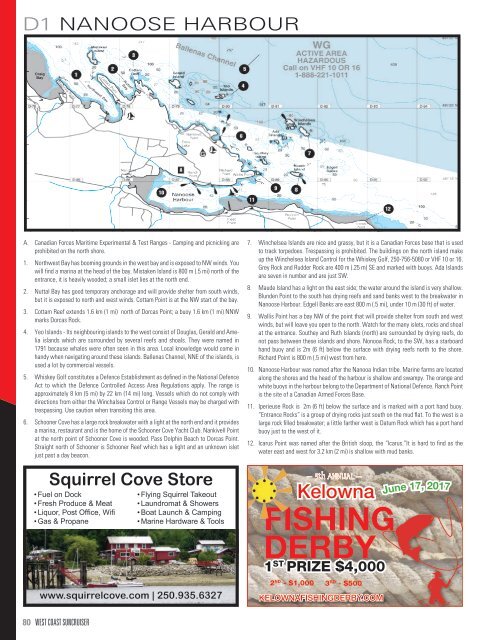
D1 NANOOSE HARBOUR<br />
A. Canadian Forces Maritime Experimental & Test Ranges - Camping and picnicking are<br />
prohibited on the north shore.<br />
1. Northwest Bay has booming grounds in the west bay and is exposed to NW winds. You<br />
will find a marina at the head of the bay. Mistaken Island is 800 m (.5 mi) north of the<br />
entrance, it is heavily wooded; a small islet lies at the north end.<br />
2. Nuttal Bay has good temporary anchorage and will provide shelter from south winds,<br />
but it is exposed to north and west winds. Cottam Point is at the NW start of the bay.<br />
3. Cottam Reef extends 1.6 km (1 mi) north of Dorcas Point; a buoy 1.6 km (1 mi) NNW<br />
marks Dorcas Rock.<br />
4. Yeo Islands - Its neighbouring islands to the west consist of Douglas, Gerald and Amelia<br />
islands which are surrounded by several reefs and shoals. They were named in<br />
1791 because whales were often seen in this area. Local knowledge would come in<br />
handy when navigating around these islands. Ballenas Channel, NNE of the islands, is<br />
used a lot by commercial vessels.<br />
5. Whiskey Golf constitutes a Defence Establishment as defined in the National Defence<br />
Act to which the Defence Controlled Access Area Regulations apply. The range is<br />
approximately 8 km (5 mi) by 22 km (14 mi) long. Vessels which do not comply with<br />
directions from either the Winchalsea Control or Range Vessels may be charged with<br />
trespassing. Use caution when transiting this area.<br />
6. Schooner Cove has a large rock breakwater with a light at the north end and it provides<br />
a marina, restaurant and is the home of the Schooner Cove Yacht Club. Nankivell Point<br />
at the north point of Schooner Cove is wooded. Pass Dolphin Beach to Dorcas Point.<br />
Straight north of Schooner is Schooner Reef which has a light and an unknown islet<br />
just past a day beacon.<br />
Squirrel Cove Store<br />
• Fuel on Dock<br />
• Fresh Produce & Meat<br />
• Liquor, Post Office, Wifi<br />
• Gas & Propane<br />
• Flying Squirrel Takeout<br />
• Laundromat & Showers<br />
• Boat Launch & Camping<br />
• Marine Hardware & Tools<br />
www.squirrelcove.com | 250.935.6327<br />
7. Winchelsea Islands are nice and grassy, but it is a Canadian Forces base that is used<br />
to track torpedoes. Trespassing is prohibited. The buildings on the north island make<br />
up the Winchelsea Island Control for the Whiskey Golf, 250-756-5080 or VHF 10 or 16.<br />
Grey Rock and Rudder Rock are 400 m (.25 m) SE and marked with buoys. Ada Islands<br />
are seven in number and are just SW.<br />
8. Maude Island has a light on the east side; the water around the island is very shallow.<br />
Blunden Point to the south has drying reefs and sand banks west to the breakwater in<br />
Nanoose Harbour. Edgell Banks are east 800 m (.5 mi), under 10 m (30 ft) of water.<br />
9. Wallis Point has a bay NW of the point that will provide shelter from south and west<br />
winds, but will leave you open to the north. Watch for the many islets, rocks and shoal<br />
at the entrance. Southey and Ruth Islands (north) are surrounded by drying reefs, do<br />
not pass between these islands and shore. Nonooa Rock, to the SW, has a starboard<br />
hand buoy and is 2m (6 ft) below the surface with drying reefs north to the shore.<br />
Richard Point is 800 m (.5 mi) west from here.<br />
10. Nanoose Harbour was named after the Nanooa Indian tribe. Marine farms are located<br />
along the shores and the head of the harbour is shallow and swampy. The orange and<br />
white buoys in the harbour belong to the Department of National Defence. Ranch Point<br />
is the site of a Canadian Armed Forces Base.<br />
11. Iperieuse Rock is 2m (6 ft) below the surface and is marked with a port hand buoy.<br />
“Entrance Rocks” is a group of drying rocks just south on the mud flat. To the west is a<br />
large rock filled breakwater; a little farther west is Datum Rock which has a port hand<br />
buoy just to the west of it.<br />
12. Icarus Point was named after the British sloop, the “Icarus.”It is hard to find as the<br />
water east and west for 3.2 km (2 mi) is shallow with mud banks.<br />
— 5th ANNUAL —<br />
Kelowna<br />
FISHING<br />
DERBY<br />
1 ST PRIZE $4,000<br />
2 ND - $1,000 3 RD - $500<br />
KELOWNAFISHINGDERBY.COM<br />
June 17, <strong>2017</strong><br />
80 WEST COAST SUNCRUISER