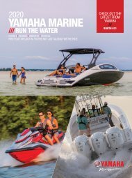
2017 SunCruiser West Coast
West Coast SunCruiser, providing you with safe boating information since 1997.
West Coast SunCruiser, providing you with safe boating information since 1997.

You also want an ePaper? Increase the reach of your titles
YUMPU automatically turns print PDFs into web optimized ePapers that Google loves.
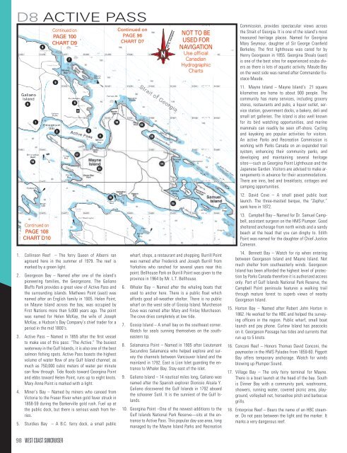
D8 ACTIVE PASS<br />
Continued on<br />
PAGE 108<br />
CHART D10<br />
Continued on<br />
PAGE 100<br />
CHART D9<br />
1. Collinson Reef – The ferry Queen of Alberni ran<br />
aground here in the summer of 1979. The reef is<br />
marked by a green light.<br />
2. Georgeson Bay – Named after one of the island’s<br />
pioneering families, the Georgesons. The Galiano<br />
Bluffs Park provides a great view of Active Pass and<br />
the surrounding islands. Mathews Point (east) was<br />
named after an English family in 1905. Helen Point,<br />
on Mayne Island across the bay, was occupied by<br />
First Nations more than 5,000 years ago. The point<br />
was named for Helen McKay, the wife of Joseph<br />
McKay, a Hudson’s Bay Company’s chief trader for a<br />
period in the mid 1800’s.<br />
3. Active Pass – Named in 1855 after the first vessel<br />
to make use of this pass: “The Active.” The busiest<br />
waterway in the Gulf Islands, it is also one of the best<br />
salmon fishing spots. Active Pass boasts the highest<br />
volume of water flow of any Gulf Island channel; as<br />
much as 750,000 cubic meters of water per minute<br />
can flow through. Tide floods toward Georgina Point<br />
and ebbs toward Helen Point, runs up to eight knots.<br />
Mary Anne Point is marked with a light.<br />
4. Miner’s Bay – Named by miners who canoed from<br />
Victoria to the Fraser River when gold fever struck in<br />
1858-59 during the Barkerville gold rush. Fuel up at<br />
the public dock, but there is serious wash from ferries.<br />
5. Sturdies Bay – A B.C. ferry dock, a small public<br />
Continued on<br />
PAGE 96<br />
CHART D7<br />
N<br />
N<br />
20ϒ E. Variation<br />
20ϒ E. Variation<br />
NOT TO BE<br />
USED FOR<br />
NAVIGATION<br />
Use official<br />
Canadian<br />
Hydrographic<br />
Charts<br />
wharf, shops, a restaurant and shopping. Burrill Point<br />
was named after Frederick and Joseph Burrill from<br />
Yorkshire who ranched for several years near this<br />
point. Bellhouse Park on Burrill Point was given to the<br />
province in 1964 by Mr. L.T. Bellhouse.<br />
6. Whaler Bay – Named after the whaling boats that<br />
used to anchor here. There is a public float which<br />
affords good all-weather shelter. There is no public<br />
wharf on the west side of Gossip Island. Murcheson<br />
Cove was named after Mary and Finlay Murcheson.<br />
The cove dries completely at low tide.<br />
7. Gossip Island – A small bay on the southeast corner.<br />
Watch for seals sunning themselves on the southeastern<br />
tip.<br />
8. Salamanca Point – Named in 1905 after Lieutenant<br />
Secundino Salamanca who helped explore and survey<br />
the channels between Vancouver Island and the<br />
mainland in 1792. East is Lion Islet guarding the entrance<br />
to Whaler Bay. Stay east of the islet.<br />
9. Galiano Island – 14 nautical miles long, Galiano was<br />
named after the Spanish explorer Dionisio Alcala Y.<br />
Galiano discovered the Gulf Islands in 1792 aboard<br />
the schooner Sutil. It is the sunniest of the Gulf Islands.<br />
10. Georgina Point –One of the newest additions to the<br />
Gulf Islands National Park Reserve—sits at the entrance<br />
to Active Pass. This popular day-use area, long<br />
managed by the Mayne Island Parks and Recreation<br />
Commission, provides spectacular views across<br />
the Strait of Georgia. It is one of the island’s most<br />
treasured heritage places. Named for Georgina<br />
Mary Seymour, daughter of Sir George Cranfield<br />
Berkeley. The first lighthouse was cared for by<br />
Henry Georgeson in 1855. Georgina Shoals (east)<br />
is one of the best sites for experienced scuba divers<br />
as there is lots of aquatic activity. Maude Bay<br />
on the west side was named after Commander Eustace<br />
Maude.<br />
11. Mayne Island – Mayne Island’s 21 square<br />
kilometres are home to about 900 people. The<br />
community has many services, including grocery<br />
stores, restaurants and pubs, a liquor outlet, service<br />
station, government docks, a bakery, deli and<br />
small art galleries. The island is also well known<br />
for its bird watching opportunities, and marine<br />
mammals can readily be seen off-shore. Cycling<br />
and kayaking are popular activities for visitors.<br />
An active Parks and Recreation Commission is<br />
working with Parks Canada on an expanded trail<br />
system, enhancing their community parks, and<br />
developing and maintaining several heritage<br />
sites—such as Georgina Point Lighthouse and the<br />
Japanese Garden. Visitors are advised to make arrangements<br />
in advance for their accommodations.<br />
There are inns, bed and breakfasts, cottages and<br />
camping opportunities.<br />
12. David Cove – A small paved public boat<br />
launch. The three-masted barque, the “Zephyr,”<br />
sank here in 1872.<br />
13. Campbell Bay – Named for Dr. Samuel Campbell,<br />
assistant surgeon on the HMS Plumper. Good<br />
sheltered anchorage from north winds and a sandy<br />
beach at the head that you can dinghy to. Edith<br />
Point was named for the daughter of Chief Justice<br />
Cameron.<br />
14. Bennett Bay – Watch for rip when entering<br />
between Georgeson Island and Mayne Island. Not<br />
much shelter from southeasterly winds. Georgeson<br />
Island has been afforded the highest level of protection<br />
by Parks Canada therefore it is authorized access<br />
only. Part of Gulf Islands National Park Reserve, the<br />
Campbell Point peninsula features a walking trail<br />
through mature forest to superb views of nearby<br />
Georgeson Island.<br />
15. Horton Bay – Named after Robert John Horton in<br />
1862. He worked for the HBC and helped the surveying<br />
officers in the region. Public wharf, small boat<br />
launch and pay phone. Curlew Island has peacocks<br />
on it. Georgeson Passage has tides and currents that<br />
run up to 5 knots.<br />
16. Conconi Reef – Honors Thomas David Conconi, the<br />
paymaster in the HMS Pylades from 1859-60. Piggott<br />
Bay offers temporary anchorage. Watch for winds<br />
blowing up Plumper Sound.<br />
17. Village Bay – The only ferry terminal for Mayne.<br />
There is a boat launch at the head of the bay. South<br />
is Dinner Bay with a community park, washrooms,<br />
showers, running water, covered picnic area, playground,<br />
volleyball net, horseshoe pitch and barbecue<br />
grills.<br />
18. Enterprise Reef – Bears the name of an HBC steamer.<br />
Do not pass between the light and the marker. It<br />
marks a very dangerous reef.<br />
98 WEST COAST SUNCRUISER