

GEOmedia 3 2017

Create successful ePaper yourself
Turn your PDF publications into a flip-book with our unique Google optimized e-Paper software.
REPORT<br />
in Albania. FLOODIS implemented<br />
a smartphone application<br />
to collect real-time reports<br />
from both citizens and civil<br />
protection agents, and to provide<br />
short and long-term projections<br />
of the flood extent for<br />
supporting in-field emergency<br />
rescue units. I-REACT extends<br />
this approach, multiplying the<br />
opportunities and serving as a<br />
tool during all the three emergency<br />
management phases, i.e.<br />
prevention, preparedness and<br />
response phases.<br />
The first one mainly deals with<br />
the preparation of a community<br />
to eliminate or reduce the impact<br />
of future disasters. For this,<br />
the I-REACT platform will<br />
integrate historical data, realtime<br />
reports, weather data and<br />
satellites observations to derive<br />
detailed statistics and accurate<br />
risk maps. These maps, coupled<br />
with a decision support system,<br />
will allow decision makers to effectively<br />
plan prevention measures<br />
aimed at increasing the<br />
resilience to future disasters.<br />
The second is the preparedness<br />
phase. During this phase, the<br />
coordination between governments,<br />
civil organizations and<br />
citizens will be promoted to be<br />
prepared in case of an emergency.<br />
To reach this objective,<br />
I-REACT will analyse weather<br />
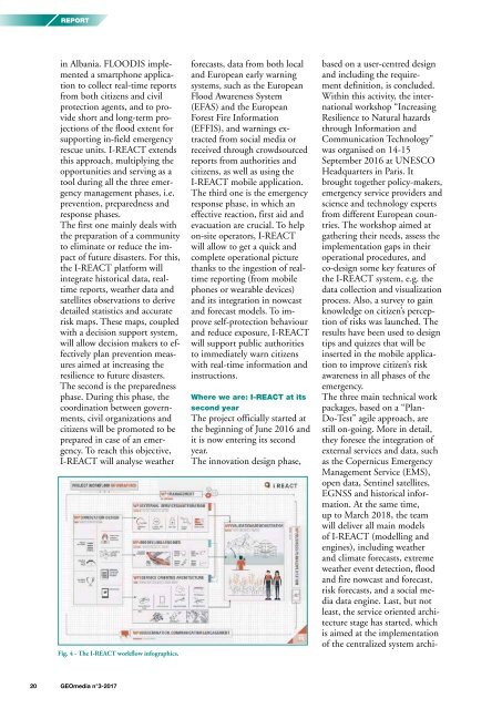
Fig. 4 - The I-REACT workflow infographics.<br />
forecasts, data from both local<br />
and European early warning<br />
systems, such as the European<br />
Flood Awareness System<br />
(EFAS) and the European<br />
Forest Fire Information<br />
(EFFIS), and warnings extracted<br />
from social media or<br />
received through crowdsourced<br />
reports from authorities and<br />
citizens, as well as using the<br />
I-REACT mobile application.<br />
The third one is the emergency<br />
response phase, in which an<br />
effective reaction, first aid and<br />
evacuation are crucial. To help<br />
on-site operators, I-REACT<br />
will allow to get a quick and<br />
complete operational picture<br />
thanks to the ingestion of realtime<br />
reporting (from mobile<br />
phones or wearable devices)<br />
and its integration in nowcast<br />
and forecast models. To improve<br />
self-protection behaviour<br />
and reduce exposure, I-REACT<br />
will support public authorities<br />
to immediately warn citizens<br />
with real-time information and<br />
instructions.<br />
Where we are: I-REACT at its<br />
second year<br />
The project officially started at<br />
the beginning of June 2016 and<br />
it is now entering its second<br />
year.<br />
The innovation design phase,<br />
based on a user-centred design<br />
and including the requirement<br />
definition, is concluded.<br />
Within this activity, the international<br />
workshop “Increasing<br />
Resilience to Natural hazards<br />
through Information and<br />
Communication Technology”<br />
was organised on 14-15<br />
September 2016 at UNESCO<br />
Headquarters in Paris. It<br />
brought together policy-makers,<br />
emergency service providers and<br />
science and technology experts<br />
from different European countries.<br />
The workshop aimed at<br />
gathering their needs, assess the<br />
implementation gaps in their<br />
operational procedures, and<br />
co-design some key features of<br />
the I-REACT system, e.g. the<br />
data collection and visualization<br />
process. Also, a survey to gain<br />
knowledge on citizen’s perception<br />
of risks was launched. The<br />
results have been used to design<br />
tips and quizzes that will be<br />
inserted in the mobile application<br />
to improve citizen’s risk<br />
awareness in all phases of the<br />
emergency.<br />
The three main technical work<br />
packages, based on a “Plan-<br />
Do-Test” agile approach, are<br />
still on-going. More in detail,<br />
they foresee the integration of<br />
external services and data, such<br />
as the Copernicus Emergency<br />
Management Service (EMS),<br />
open data, Sentinel satellites,<br />
EGNSS and historical information.<br />
At the same time,<br />
up to March 2018, the team<br />
will deliver all main models<br />
of I-REACT (modelling and<br />
engines), including weather<br />
and climate forecasts, extreme<br />
weather event detection, flood<br />
and fire nowcast and forecast,<br />
risk forecasts, and a social media<br />
data engine. Last, but not<br />
least, the service oriented architecture<br />
stage has started, which<br />
is aimed at the implementation<br />
of the centralized system archi-<br />
20 <strong>GEOmedia</strong> n°3-<strong>2017</strong>


