

GEOmedia 3 2017

You also want an ePaper? Increase the reach of your titles
YUMPU automatically turns print PDFs into web optimized ePapers that Google loves.
In this<br />
issue...<br />
FOCUS<br />
REPORT<br />
COLUMNS<br />
36 NEWS<br />
New Trends in<br />
Geomatics, in the Era<br />
of Lowcost Sensors,<br />
Free and Open<br />
Source Software and<br />
HPC GeoBigData<br />
infrastructures<br />
by Roberta Ravanelli, Martina<br />
Di Rita, Valeria Belloni,<br />
Andrea Nascetti, Augusto<br />
Mazzoni, Mattia Crespi<br />
6<br />
46 AGENDA<br />
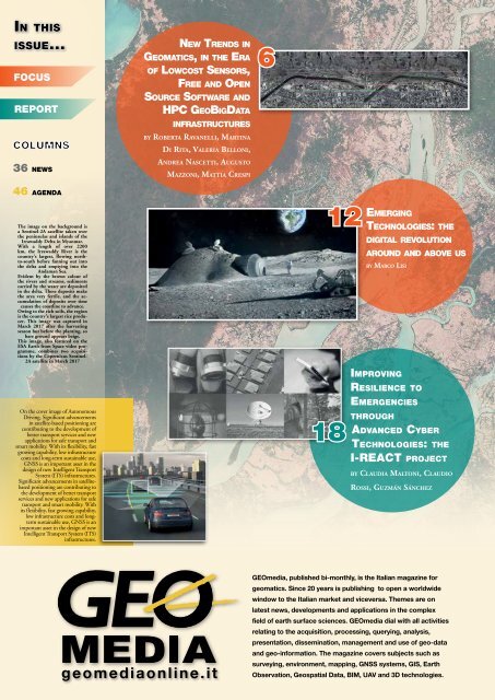
The image on the background is<br />
a Sentinel-2A satellite taken over<br />
the peninsulas and islands of the<br />
Irrawaddy Delta in Myanmar.<br />
With a length of over 2200<br />
km, the Irrawaddy River is the<br />
country's largest, flowing northto-south<br />
before fanning out into<br />
the delta and emptying into the<br />
Andaman Sea.<br />
Evident by the brown colour of<br />
the rivers and streams, sediments<br />
carried by the water are deposited<br />
in the delta. These deposits make<br />
the area very fertile, and the accumulation<br />
of deposits over time<br />
causes the coastline to advance.<br />
Owing to the rich soils, the region<br />
is the country’s largest rice producer.<br />
This image was captured in<br />
March <strong>2017</strong> after the harvesting<br />
season but before the planting, so<br />
bare ground appears beige.<br />
This image, also featured on the<br />
ESA Earth from Space video programme,<br />
combines two acquisitions<br />
by the Copernicus Sentinel-<br />
2A satellite in March <strong>2017</strong><br />
On the cover image of Autonomous<br />
Driving. Significant advancements<br />
in satellite-based positioning are<br />
contributing to the development of<br />
better transport services and new<br />
applications for safe transport and<br />
smart mobility. With its flexibility, fast<br />
growing capability, low infrastructure<br />
costs and long-term sustainable use,<br />
GNSS is an important asset in the<br />
design of new Intelligent Transport<br />
System (ITS) infrastructures.<br />
Significant advancements in satellitebased<br />
positioning are contributing to<br />
the development of better transport<br />
services and new applications for safe<br />
transport and smart mobility. With<br />
its flexibility, fast growing capability,<br />
low infrastructure costs and longterm<br />
sustainable use, GNSS is an<br />
important asset in the design of new<br />
Intelligent Transport System (ITS)<br />
infrastructures.<br />
12<br />
18<br />
Emerging<br />
Technologies: the<br />
digital revolution<br />
around and above us<br />
by Marco Lisi<br />
Improving<br />
Resilience to<br />
Emergencies<br />
through<br />
Advanced Cyber<br />
Technologies: the<br />
I-REACT project<br />
by Claudia Maltoni, Claudio<br />
Rossi, Guzmán Sánchez<br />
geomediaonline.it<br />
<strong>GEOmedia</strong>, published bi-monthly, is the Italian magazine for<br />
geomatics. Since 20 years is publishing to open a worldwide<br />
window to the Italian market and viceversa. Themes are on<br />
latest news, developments and applications in the complex<br />
field of earth surface sciences. <strong>GEOmedia</strong> dial with all activities<br />
relating to the acquisition, processing, querying, analysis,<br />
presentation, dissemination, management and use of geo-data<br />
and geo-information. The magazine covers subjects such as<br />
surveying, environment, mapping, GNSS systems, GIS, Earth<br />
Observation, Geospatial Data, BIM, UAV and 3D technologies.


