

GEOmedia 3 2017

You also want an ePaper? Increase the reach of your titles
YUMPU automatically turns print PDFs into web optimized ePapers that Google loves.
REPORT<br />
VGI and crisis mapping in an<br />
emergency situation<br />
Comparison of four case studies: Haiti, Kibera, Kathmandu, Centre Italy<br />
di Lucia Saganeiti, Federico Amato, Gabriele Nolè, Beniamino Murgante<br />
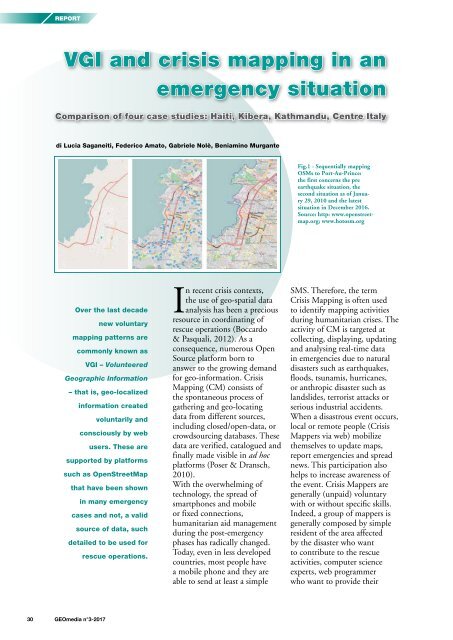
Fig.1 - Sequentially mapping<br />
OSMs to Port-Au-Prince:<br />
the first concerns the pre<br />
earthquake situation, the<br />
second situation as of January<br />
29, 2010 and the latest<br />
situation in December 2016.<br />
Source: http: www.openstreetmap.org;<br />
www.hotosm.org<br />
Over the last decade<br />
new voluntary<br />
mapping patterns are<br />
commonly known as<br />
VGI – Volunteered<br />
Geographic Information<br />
– that is, geo-localized<br />
information created<br />
voluntarily and<br />
consciously by web<br />
users. These are<br />
supported by platforms<br />
such as OpenStreetMap<br />
that have been shown<br />
in many emergency<br />
cases and not, a valid<br />
source of data, such<br />
detailed to be used for<br />
rescue operations.<br />
In recent crisis contexts,<br />
the use of geo-spatial data<br />
analysis has been a precious<br />
resource in coordinating of<br />
rescue operations (Boccardo<br />
& Pasquali, 2012). As a<br />
consequence, numerous Open<br />
Source platform born to<br />
answer to the growing demand<br />
for geo-information. Crisis<br />
Mapping (CM) consists of<br />
the spontaneous process of<br />
gathering and geo-locating<br />
data from different sources,<br />
including closed/open-data, or<br />
crowdsourcing databases. These<br />
data are verified, catalogued and<br />
finally made visible in ad hoc<br />
platforms (Poser & Dransch,<br />
2010).<br />
With the overwhelming of<br />
technology, the spread of<br />
smartphones and mobile<br />
or fixed connections,<br />
humanitarian aid management<br />
during the post-emergency<br />
phases has radically changed.<br />
Today, even in less developed<br />
countries, most people have<br />
a mobile phone and they are<br />
able to send at least a simple<br />
SMS. Therefore, the term<br />
Crisis Mapping is often used<br />
to identify mapping activities<br />
during humanitarian crises. The<br />
activity of CM is targeted at<br />
collecting, displaying, updating<br />
and analysing real-time data<br />
in emergencies due to natural<br />
disasters such as earthquakes,<br />
floods, tsunamis, hurricanes,<br />
or anthropic disaster such as<br />
landslides, terrorist attacks or<br />
serious industrial accidents.<br />
When a disastrous event occurs,<br />
local or remote people (Crisis<br />
Mappers via web) mobilize<br />
themselves to update maps,<br />
report emergencies and spread<br />
news. This participation also<br />
helps to increase awareness of<br />
the event. Crisis Mappers are<br />
generally (unpaid) voluntary<br />
with or without specific skills.<br />
Indeed, a group of mappers is<br />
generally composed by simple<br />
resident of the area affected<br />
by the disaster who want<br />
to contribute to the rescue<br />
activities, computer science<br />
experts, web programmer<br />
who want to provide their<br />
30 <strong>GEOmedia</strong> n°3-<strong>2017</strong>


