

GEOmedia 3 2017

You also want an ePaper? Increase the reach of your titles
YUMPU automatically turns print PDFs into web optimized ePapers that Google loves.
REPORT<br />
The new MSc in Geoinformatics<br />
Engineering at Politecnico di Milano<br />
by Ludovico Biagi<br />
This paper describes the first<br />
italian MSc in Geoinformatics<br />
Engineering started in 2016 at<br />
Politecnico di Milano.<br />
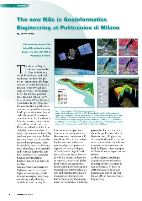
Fig. 1 - Four examples of Geoinformatics expertizes.<br />
Upper, left. Positioning by GNSS (a GPS III satellite, United States Government).<br />
Upper, right. Analysis of remote sensed images (LandSat multispectral image of Como<br />
lake, GeoLab of Politecnico di Milano). Lower, left. Creation and analysis of digital<br />
elevation models (example of high resolution DEM from LiDAR, GeoLab of Politecnico<br />
di Milano). Lower, right. Advanced environmental analysis (4D modelling of temperatures<br />
in the Mediterranean sea, GeoLab of Politecnico di Milano).<br />
The vision of Digital<br />
Earth was proposed by<br />
Al Gore in 1998 as a<br />
multi-dimensional and multiresolution<br />
model of the planet<br />
to contextualize the huge<br />
amount of spatial information<br />
relating to the physical and<br />
socio-economic environment.<br />
Every day humans generate<br />
more than 2.5 trillion (10 18 )<br />
bytes of data: 80% of them are<br />
spatial data. In the ‘80 of the<br />
last century, first digital spatial<br />
data were acquired by scanning<br />
hardcopy archives; now they are<br />
endlessly acquired in massive<br />
quantities from fixed and mobile<br />
in-situ sensors, from sensors<br />
on satellites, on aircrafts, on<br />
UAVs or on land vehicles, from<br />
digital documents and social<br />
media. Such a massive flow (Big<br />
geodata) generates new challenges<br />
since stored data have to be<br />
analyzed and processed, often<br />
in real-time, to extract information.<br />
Therefore, a new scientific<br />
and technical figure who combines<br />
expertizes in Computer<br />
Science, Environmental<br />
Engineering and Geomatics is<br />
needed.<br />
Geoinformatics engineers are<br />
high level experts in technologies<br />
for measuring, georeferencing,<br />
managing, analyzing,<br />
visualizing and publishing<br />
spatial and time varying information,<br />
with a particular<br />
concern to environmental data.<br />
Geoinformatics engineers will<br />
thus be involved in the design,<br />
implementation and management<br />
of geodata projects to<br />
support the new paradigms<br />
of Participative Digital Earth,<br />
Smart City and Smart Society<br />
as well as a variety of decisions<br />
at regional, country and global<br />
level. Urban and agricultural<br />
land planning, monitoring and<br />
management, infrastructure design<br />
and building information<br />
management, transport and<br />
traffic monitoring and management,<br />
environmental modeling,<br />
geography, Earth sciences are<br />
the main application fields of<br />
Geoinformatics Engineering.<br />
All those fields attain to the general<br />
context of sustainable management<br />
of environment and<br />
land. In Figure 1, few examples<br />
of Geoinformatics expertizes are<br />
shown.<br />
As the academic teaching is<br />
concerned, some universities<br />
in Europe propose courses in<br />
Geoinformatics. In Italy, in<br />
2016 Politecnico di Milano<br />
planned and started the first<br />
Italian MSc in Geoinformatics<br />
Engineering.<br />
26 <strong>GEOmedia</strong> n°3-<strong>2017</strong>


