Dungeon Master's Guide

Create successful ePaper yourself
Turn your PDF publications into a flip-book with our unique Google optimized e-Paper software.
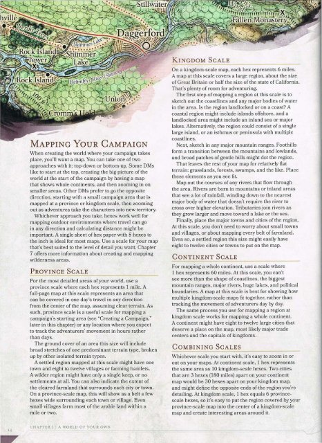
MAPPING YouR CAMPAIGN<br />
When creating the world where your campaign takes<br />
place, you'll want a map. You can take one of two<br />
approaches with it: top-down or bottom-up. Some DMs<br />
like to start at the top, creating the big picture of the<br />
world at the start of the campaign by having a map<br />
that shows whole continents, and then zooming in on<br />
smaller areas. Other DMs prefer to go the opposite<br />
direction, starting with a small campaign area that is<br />
mapped at a province or kingdom scale, then zooming<br />
out as adventures take the characters into new territory.<br />
Whichever approach you take, hexes work well for<br />
mapping outdoor environments where travel can go<br />
in any direction and calculating distance might be<br />
important. A single sheet of hex paper with 5 hexes to<br />
the inch is ideal for most maps. Use a scale for your map<br />
that's best suited to the level of detail you want. Chapter<br />
7 offers more information about creating and mapping<br />
wilderness areas.<br />
PROVINCE SCALE<br />
For the most detailed areas of your world, use a<br />
province scale where each hex represents 1 mile. A<br />
full-page map at this scale represents an area that<br />
can be covered in one day's travel in any direction<br />
from the center of the map, assuming clear terrain. As<br />
such, province scale is a useful scale for mapping a<br />
campaign's starting area (see "Creating a Campaign,"<br />
later in this chapter) or any location where you expect<br />
to track the adventurers' movement in hours rather<br />
than days.<br />
•<br />
The ground cover of an area this size will include<br />
broad stretches of one predominant terrain type, broken<br />
up by other isolated terrain types.<br />
A settled region mapped at this scale might have one<br />
town and eight to twelve villages or farming hamlets.<br />
A wilder region might have only a single keep, or no<br />
settlements at all. You can also indicate the extent of<br />
the cleared farmland that surrounds each city or town.<br />
On a province-scale map, this will show as a belt a few<br />
hexes wide surrounding each town or village. Even<br />
small villages farm most of the arable land within a<br />
mile or two.<br />
KINGDOM SCALE<br />
On a kingdom-scale map, each hex represents 6 miles.<br />
A map at this scale covers a large region, about the size<br />
of Great Britain or half the size of the state of California.<br />
That's plenty of room for adventuring.<br />
The first step of mapping a region at this scale is to<br />
sketch out the coastlines and any major bodies of water<br />
in the area. Is the region landlocked or on a coast? A<br />
coastal region might include islands offshore, and a<br />
landlocked area might include an inland sea or major<br />
lakes. Alternatively, the region could consist of a single<br />
large island, or an isthmus or peninsula with multiple<br />
coastlines.<br />
Next, sketch in any major mountain ranges. Foothills<br />
form a transition between the mountains and lowlands,<br />
and broad patches of gentle hills might dot the region.<br />
That leaves the rest of your map for relatively fiat<br />
terrain: grasslands, forests, swamps, and the like. Place<br />
these elements as you see fit.<br />
Map out the courses of any rivers that flow through<br />
the area. Rivers are born in mountains or inland areas<br />
that see a lot of rainfall, winding down to the nearest<br />
major body of water that doesn't require the river to<br />
cross over higher elevation. Tributaries join rivers as<br />
they grow larger and move toward a lake or the sea.<br />
Finally, place the major towns and cities of the region.<br />
At this scale, you don't need to worry about small towns<br />
and villages, or about mapping every belt of farmland.<br />
Even so, a settled region this size might easily have<br />
eight to twelve cities or towns to put on the map.<br />
CONTINENT SCALE<br />
For mapping a whole continent, use a scale where<br />
1 hex represents 60 miles. At this scale, you can't<br />
see more than the shape of coastlines, the biggest<br />
mountain ranges, major rivers, huge lakes, and political<br />
boundaries. A map at this scale is best for showing how<br />
multiple kingdom-scale maps fi t together, rather than<br />
tracking the movement of adventurers day by day.<br />
The same process you use for mapping a region at<br />
kingdom scale works for mapping a whole continent.<br />
A continent might have eight to twelve large cities that<br />
deserve a place on the map, most likely major trade<br />
centers and the capitals of kingdoms.<br />
COMBINING SCALES<br />
--~--------------<br />
Whichever scale you start with, it's easy to zoom in or<br />
out on your maps. At continent scale, 1 hex represents<br />
the same area as 10 kingdom-scale hexes. Two cities<br />
that are 3 hexes (180 miles) apart on your continent<br />
map would be 30 hexes apart on your kingdom map,<br />
and might define the opposite ends of the region you're<br />
detailing. At kingdom scale, 1 hex equals 6 provincescale<br />
hexes, so it's easy to put the region covered by your<br />
province-scale map into the center of a kingdom-scale<br />
map and create interesting areas around it.<br />
I4<br />
CHAPTER 1 I A WORLD OF YOUR OWN