


Create successful ePaper yourself
Turn your PDF publications into a flip-book with our unique Google optimized e-Paper software.
REPORT<br />
Revising the geological<br />
mapping of Mars<br />
by Marco Pantaloni, Roberto Graciotti,<br />
Lucia Marinangeli, Matteo Massironi<br />
The geological map is a unique graphical tool that summarises<br />
through colours and symbols, the complex evolution of a planet.<br />
It requires the combination of many different characteristics<br />
of the studied rock sequences including lithology, stratigraphy<br />
and structural deformation to reconstruct the variation of<br />
environments and climates through time. Although based on<br />
the same basic principles as on Earth, planetary geological -<br />
geomorphological mapping has some peculiarities which need to<br />
be addressed in order to standardize the technical and scientific<br />
approach.<br />
The standards of planetary cartography have long been based on<br />
principles defined in the 1970s during the Apollo missions, while<br />
recently it is emerged the need to develop new cartographic<br />
guidelines in the light of advances in the understanding of<br />
geological processes that shape planetary surfaces.<br />
Furthermore, the plethora of new data derived from recent space<br />
missions and the possibility of identifying resources to be used<br />
in situ in view of permanent stations on the Moon and eventually<br />
Mars accentuate this need. This was recently faced by the USGS,<br />
which since the Apollo Era has continuously produced geological<br />
mapping of the surfaces of other planets and by a network of<br />
PLANMAP (https://planmap.eu/).<br />
In this framework, the Geological Survey of Italy, ISPRA, recently<br />
started a collaboration with the Italian Space Agency (ASI), the<br />
National Institute of Astrophysics (INAF) and the Universities of<br />
Chieti, Cagliari, Naples Federico II, Padua, Perugia and Jacobs<br />
University of Bremen. The aim of the project is the attempt to apply the<br />
cartographic standards rules used in the Italian Geological Mapping Project<br />
(CARG Project) for the realization of geological and geomorphological maps<br />
at various scales of detail even in the planetary environments.<br />
Thanks to the excellent coverage of high-resolution images of HiRISE (High<br />
Resolution Imaging Science Experiment) and the availability of medium<br />
and high resolution DTMs of some specific sectors of its surface, the<br />
applicability of the cartographic guidelines, published by the Geological<br />
Survey of Italy in the “Quaderni” series (http://www.isprambiente.gov.<br />
European scientific institutes involved in the pilot project H2020-<br />
it/it/progetti/suolo-e-territorio-1/progetto-carg-cartografia-geologica-egeotematica/linee-guida),<br />
is being tested. In this preliminary phase of the<br />
work, has been tested the production of geological and geomorphological<br />
maps of some sample areas of planet Mars.<br />
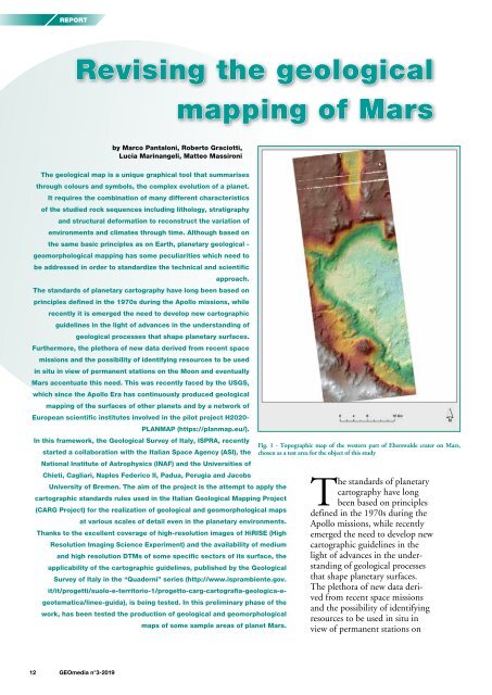
Fig. 1 - Topographic map of the western part of Eberswalde crater on Mars,<br />
chosen as a test area for the object of this study<br />
The standards of planetary<br />
cartography have long<br />
been based on principles<br />
defined in the 1970s during the<br />
Apollo missions, while recently<br />
emerged the need to develop new<br />
cartographic guidelines in the<br />
light of advances in the understanding<br />
of geological processes<br />
that shape planetary surfaces.<br />
The plethora of new data derived<br />
from recent space missions<br />
and the possibility of identifying<br />
resources to be used in situ in<br />
view of permanent stations on<br />
12 <strong>GEOmedia</strong> n°3-<strong>2019</strong>


