


You also want an ePaper? Increase the reach of your titles
YUMPU automatically turns print PDFs into web optimized ePapers that Google loves.
NEWS<br />
C’è vita nel nostro mondo.<br />
Realizzazione di infrastrutture<br />
dati territoriali (SDI) conformi a INSPIRE<br />
Formazione specialistica su tecnologie<br />
GIS Open Source<br />
INSPIRE Helpdesk<br />
We support all INSPIRE implementers<br />
Epsilon Italia S.r.l.<br />
Via Pasquali, 79<br />
87040 Mendicino (CS)<br />
Tel. e Fax (+39) 0984 631949<br />
info@epsilon-italia.it<br />
www.epsilon-italia.it<br />
www.inspire-helpdesk.eu<br />
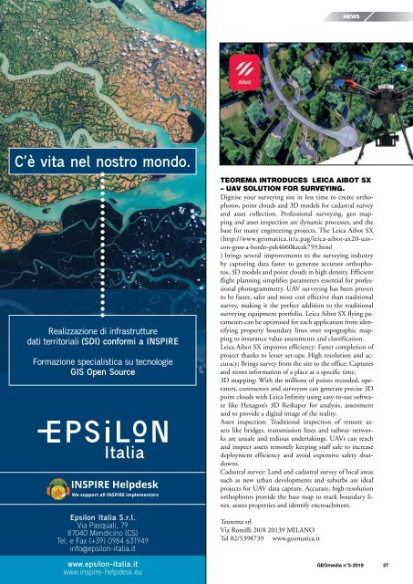
TEOREMA INTRODUCES LEICA AIBOT SX<br />
– UAV SOLUTION FOR SURVEYING.<br />
Digitise your surveying site in less time to create orthophotos,<br />
point clouds and 3D models for cadastral survey<br />
and asset collection. Professional surveying, geo mapping<br />
and asset inspection are dynamic processes, and the<br />
base for many engineering projects. The Leica Aibot SX<br />
(http://www.geomatica.it/a.pag/leica-aibot-ax20-uavcon-gnss-a-bordo-pzk4660kzczk759.html<br />
) brings several improvements to the surveying industry<br />
by capturing data faster to generate accurate orthophotos,<br />
3D models and point clouds in high density. Efficient<br />
flight planning simplifies parameters essential for professional<br />
photogrammetry. UAV surveying has been proven<br />
to be faster, safer and more cost effective than traditional<br />
survey, making it the perfect addition to the traditional<br />
surveying equipment portfolio. Leica Aibot SX flying parameters<br />
can be optimised for each application from identifying<br />
property boundary lines over topographic mapping<br />
to insurance value assessments and classification.<br />
Leica Aibot SX improves efficiency: Faster completion of<br />
project thanks to lesser set-ups; High resolution and accuracy;<br />
Brings survey from the site to the office; Captures<br />
and stores information of a place at a specific time.<br />
3D mapping: With the millions of points recorded, operators,<br />
contractors and surveyors can generate precise 3D<br />
point clouds with Leica Infinity using easy-to-use software<br />
like Hexagon’s 3D Reshaper for analysis, assessment<br />
and to provide a digital image of the reality.<br />
Asset inspection: Traditional inspection of remote assets<br />
like bridges, transmission lines and railway networks<br />
are unsafe and tedious undertakings. UAVs can reach<br />
and inspect assets remotely keeping staff safe to increase<br />
deployment efficiency and avoid expensive safety shutdowns.<br />
Cadastral survey: Land and cadastral survey of local areas<br />
such as new urban developments and suburbs are ideal<br />
projects for UAV data capture. Accurate, high-resolution<br />
orthophotos provide the base map to mark boundary lines,<br />
assess properties and identify encroachment.<br />
Teorema srl<br />
Via Romilli 20/8 20139 MILANO<br />
Tel 02/5398739 www.geomatica.it<br />
<strong>GEOmedia</strong> n°3-<strong>2019</strong> 27


