


Create successful ePaper yourself
Turn your PDF publications into a flip-book with our unique Google optimized e-Paper software.
NEWS<br />
THE POTENTIAL OF LIDAR SYSTEMS<br />
AND POST-PROCESSING SOFTWARE<br />
The potential of the LiDAR systems and the post-processing<br />
software increases day by day. The industry is<br />
always looking for new technologies and new solutions<br />
to improve productivity and efficiency. LiDAR sensor<br />
provide speed, accuracy, processing automation and the<br />
ability to easily integrate into existing engineering and<br />
GIS workflows.<br />
The most known applications are in aerial, UAV or automotive<br />
systems. But what about using LiDAR in a terrestrial<br />
system, specifically, handheld mobile lidar systems?<br />
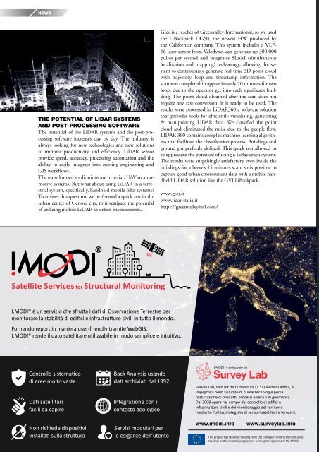
To answer this question, we performed a quick test in the<br />
urban center of Genova city, to investigate the potential<br />
of utilizing mobile LiDAR in urban environments.<br />
Gter is a reseller of Greenvalley International, so we used<br />
the LiBackpack DG50, the newest HW produced by<br />
the Californian company. This system includes a VLP-<br />
16 laser sensor from Velodyne, can generate up 300.000<br />
pulses per second and integrates SLAM (simultaneous<br />
localization and mapping) technology, allowing the system<br />
to continuously generate real time 3D point cloud<br />
with trajectory, loop and timestamp information. The<br />
scan was completed in approximately 20 minutes for two<br />
loop, due to the operator get into each significant building.<br />
The point cloud obtained after the scan does not<br />
require any raw conversion, it is ready to be used. The<br />
results were processed in LiDAR360 a software solution<br />
that provides tools for efficiently visualizing, generating<br />
& manipulating LiDAR data. We classified the point<br />
cloud and eliminated the noise due to the people flow.<br />
LIDAR 360 contains complex machine learning algorithms<br />
that facilitate the classification process. Buildings and<br />
ground got perfectly defined. This quick test allowed us<br />
to appreciate the potential of using a LiBackpack system.<br />
The results were surprisingly satisfactory even inside the<br />
buildings for a breve’s 15 minutes scan, so is possible to<br />
capture good urban environment data with a mobile handheld<br />
LiDAR solution like the GVI LiBackpack.<br />
www.gter.it<br />
www.lidar-italia.it<br />
https://greenvalleyintl.com/<br />
®<br />
Satellite Services for Structural Monitoring<br />
I.MODI® è un servizio che sfrutta i dati di Osservazione Terrestre per<br />
monitorare la stabilità di edifici e infrastrutture civili in tutto il mondo.<br />
Fornendo report in maniera user-friendly tramite WebGIS,<br />
I.MODI® rende il dato satellitare utilizzabile in modo semplice e intuitivo.<br />
Controllo sistematico<br />
di aree molto vaste<br />
Dati satellitari<br />
facili da capire<br />
Non richiede dispositivi<br />
installati sulla struttura<br />
28 <strong>GEOmedia</strong> n°3-<strong>2019</strong><br />
Back Analysis usando<br />
dati archiviati dal 1992<br />
Integrazione con il<br />
contesto geologico<br />
Servizi modulari per<br />
le esigenze dell’utente<br />
I.MODI® è sviluppato da<br />
Survey Lab, spin off dell’Università La Sapienza di Roma, è<br />
impegnata nello sviluppo di nuove tecnologie per la<br />
realizzazione di prodotti, processi e servizi di geomatica.<br />
Dal 2008 opera nel campo del controllo di edifici e<br />
infrastrutture civili e del monitoraggio del territorio<br />
mediante l’utilizzo integrato di sensori satellitari e terrestri.<br />
www.imodi.info<br />
www.surveylab.info<br />
This project has received funding from the European Union’s Horizon 2020<br />
research and innovation programme under grant agreement No 720121


