No. 12 - Its Gran Canaria Magazine
Rutas, recomendaciones y noticias de Gran Canaria Routes, tips and news about Gran Canaria
Rutas, recomendaciones y noticias de Gran Canaria
Routes, tips and news about Gran Canaria

Create successful ePaper yourself
Turn your PDF publications into a flip-book with our unique Google optimized e-Paper software.
10<br />
GET TO KNOW GRAN CANARIA I CONOCE GRAN CANARIA Nº <strong>12</strong><br />
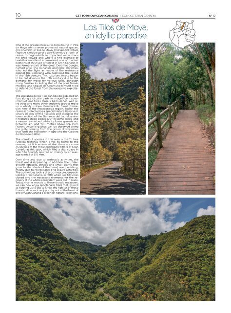
Los Tilos de Moya,<br />
an idyllic paradise<br />
One of the greatest treasures to be found in Villa<br />
de Moya are its seven protected natural spaces,<br />
one of which is Tilos de Moya. This Special Nature<br />
Reserve is made up of a two-kilometre stretch of<br />
ravine, through which an important water channel<br />
once flowed and where a fine example of<br />
laurisilva woodland is preserved, one of the last<br />
bastions of this type of forest in <strong>Gran</strong> <strong>Canaria</strong>. It<br />
was formerly part of the great Doramas Jungle,<br />
named after the <strong>Canaria</strong>n aborigine Doramas,<br />
who led the fight as leader of the resistance<br />
against the Castilians who colonised the island<br />
in the 15th century. This luxuriant forest began<br />
to be cut down in the 16th century due to the<br />
demand for wood for various uses, although<br />
many families including that of the poet Tomás<br />
Morales, and Miguel de Unamuno himself, tried<br />
to defend the forest from this excessive exploitation.<br />
The Barranco de los Tilos can now be explored on<br />
foot along a circular path. <strong>Its</strong> magnificent specimens<br />
of lime trees, laurels, barbusanos, wild olive<br />
trees and many other endemic species make<br />
up a wholly unique thermophilic forest formation<br />
here in the Macaronesia region. Today, the<br />
ravine is protected as a Special Nature Reserve. It<br />
covers an area of 91.5 hectares and occupies the<br />
lower section of the Barranco del Laurel ravine.<br />
It features steep slopes (90º in some areas) and<br />
a narrow ravine bed, while its forest spreads out<br />
between 475 and 700 metres above sea level.<br />
Recent volcanic gashes can be observed along<br />
the gully, coming from the group of volcanoes<br />
that form the Montañón Negro and the Caldera<br />
de Pinos de Gáldar.<br />
The standout species in this area is the Til tree<br />
(Ocotea foctens), which gives its name to the<br />
reserve, but it is estimated that there are some<br />
35 species of the most endangered flora of <strong>Gran</strong><br />
<strong>Canaria</strong> at this spot, which find a vital space in<br />
which to flourish, spurred on mainly by an average<br />
rainfall of 510 mm.<br />
Over time and due to anthropic activities, the<br />
forest was disappearing. In addition, the undergrowth<br />
(grasses, shrubs and small plants that<br />
grow in the shade of the trees) was perishing,<br />
mainly due to recreational and leisure activities.<br />
The authorities took a drastic measure, unparalleled<br />
in <strong>Gran</strong> <strong>Canaria</strong>, in 1980, when Los Tilos was<br />
closed and the necessary elements for the recovery<br />
of the whole ecosystem were put in place.<br />
Today, thanks mostly to those drastic measures,<br />
we can now enjoy spectacular trails that, as well<br />
as helping us to get to know the habitat of these<br />
forests, allow us to enjoy a day out at the heart of<br />
one of <strong>Gran</strong> <strong>Canaria</strong>’s greenest natural locations.