The STaTe hermiTage muSeum annual reporT
The STaTe hermiTage muSeum annual reporT
The STaTe hermiTage muSeum annual reporT

You also want an ePaper? Increase the reach of your titles
YUMPU automatically turns print PDFs into web optimized ePapers that Google loves.
archaeoloGIcal expeDItIons archaeoloGIcal expeDItIons<br />
wooden half-beams were found. <strong>The</strong> section of the east wall<br />
of the trench shows that the pad is covered with a layer<br />
containing the same organic inclusions as the pad surface.<br />
At the depth of 1.7 m from the present surface of the<br />
mound, this layer is covered with clay and sand coating<br />
carrying fragments of moulded Early Meot pottery.<br />
A Bronze Age catacomb burial was found with a destroyed<br />
vault and the entrance well with two steps on the south<br />
(explored in 1897) in the part of Veselovsky’s trench adjacent<br />
to the east wall section of the present trench. <strong>The</strong> catacomb<br />
was found to contain fragments of broken covering<br />
slabs, human bones and ceramic fragments.<br />
An unexplored Bronze Age pit burial was found to the<br />
south of the catacomb.<br />
<strong>The</strong> early stage of advanced exploratory works on the Kostromskoi<br />
Mound confirmed some data quoted in N. Veselovsky’s<br />
report; however, no reliable evidence of a tentshaped<br />
sub-mound structure has been found.<br />
goldern horde expediTion<br />
Head of expedition: Mark Kramarovsky<br />
Exploratory works continued on the defence line of mediaeval<br />
Solkhat. Three pits were made on the ridge of the<br />
south-east branch of Maly Argamysh Mountain. Walls of<br />
an open-type defence tower measuring 10 × 10 m were<br />
found in Pit XXXIII; remains of a forge (?) including<br />
a furnace chamber and a mouth with a pre-furnace<br />
area were unearthed in one area of the excavation site.<br />
Pit XXXIV contained the foundation of the defence wall.<br />
<strong>The</strong> defence wall line includes a three-part trench consisting<br />
of the central recess filled with crushed stone and<br />
lime mortar, and light clay substructures adjacent to the<br />
recess on the north and south which were intended for<br />
constructing the footing course of the defence wall jacket.<br />
<strong>The</strong> total width of the trench for the bedding and packing<br />
of the defence wall was about 2.5 m. <strong>The</strong> wall consisted of<br />
two jackets made from stones fixed together with mortar.<br />
<strong>The</strong> space between the jackets was filled with rubble and<br />
the same type of mortar. <strong>The</strong> profiles of the sides and edges<br />
of the pit support the findings of the previous season.<br />
In the south-west corner of the site, a burial of a woman<br />
and child without any inventory was found at the depth<br />
of 0.37 m. <strong>The</strong> burial was covered with reused facing slabs<br />
of the defence wall.<br />
In Pit XXXV the infill of the central part of the trench for<br />
the defence wall was clearly localized. At the bottom on<br />
the east and west parts of the trench medium and large<br />
stones fixed together with clay mortar were preserved in<br />
situ, which apparently formed part of the wall foundation<br />
on the site.<br />
<strong>The</strong> finds included fragments of metal objects of unknown<br />
use and nails; an arrowhead; fragments of bone objects<br />
and pottery fragments; a four-part caltrop; an anthropomorphic<br />
figurine made of a metal (brass?) plate – ongon,<br />
and a fragment of a tomb.<br />
A total of 23 coins were found, two of which were worn<br />
out, one had been minted in Turkey, one in Moldavia<br />
(stamp of Alexander the Kind (1400–1432?)), one in Russia<br />
(1730–1740). <strong>The</strong> other coins were copper Jochid puls<br />
(one with a Genoese portal stamp). A Russian grosh, minted<br />
during Anna Ioannovna’s reign, allows to define the<br />
period when the walls of mediaeval Solkhat’s defence belt<br />
were dismantled and their stones were reused.<br />
myrmeKeyon expediTion<br />
Head of expedition: Alexander Butiagin<br />
Works continued on the site of the ancient city of Myrmekeyon<br />
located on the territory of Kerch. Excavations<br />
were performed on Ash Pit 2 as well as to the north of<br />
it, in the north-west corner of the adjacent Site И (I).<br />
Poorly preserved walls of buildings dating back to the<br />
first centuries A.D. were found. On the main site, the<br />
ash pit was explored to the depth of 0.8 m. Apart from<br />
the areas completely destroyed by later excavations, the<br />
occupation layer had a typical ash pit stratigraphy, with<br />
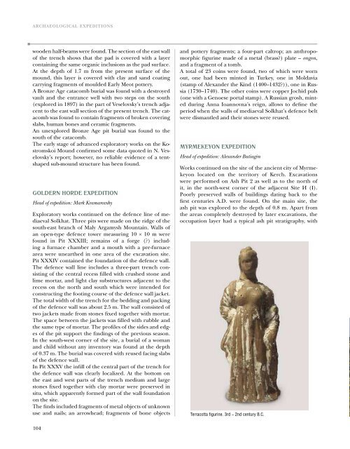
Terracotta figurine. 3rd – 2nd century B.C.<br />
alternating layers of grey and brown ash loam and multiple<br />
fragments of mussels, ash, baked soil, coals and small<br />
stones. <strong>The</strong> ash pit layers contained abundant ceramic<br />
material, including over a hundred fragments of branded<br />
amphorae from Sinop, Heraclea, Rhodes, Cnidus and<br />
other cities, terracotta fragments, copper coins and fragments<br />
of ceramic vessels with graffiti. One special find<br />
was a remarkably well-preserved terracotta figurine of<br />
a standing woman. For the first time, a seriously damaged<br />
gold bead was found in the ash pit. This area of the<br />
ash pit was bounded by stone and adobe walls separating<br />
it from the residential structures. A major part of the ash<br />
pit was disturbed by wartime groundwork. Excavations of<br />
the shelter and driveway yielded a considerable amount<br />
of wartime material including fourteen cannon shells.<br />
<strong>The</strong> shelter preserved the frame of a car damaged by<br />
an explosion as well as scattered human bones, possibly<br />
coming from the same body.<br />
nymphaeum expediTion<br />
Head of expedition: Olga Sokolova<br />
Exploratory works continued on the Bosporan town of<br />
Nymphaeum (Kerch, Crimean AR, Ukraine), on the south<br />
slope of the Nymphaeum Plateau, where field research has<br />
been conducted on the sacred ground complex for many<br />
years.<br />
On the West Excavation Pit, removal of the overlying level<br />
continued to the south of the propylaea explored in 1996–<br />
2000 in order to identify the building system in the area.<br />
No building remains were found. <strong>The</strong> layer comprised material<br />
mostly dating from the 4th – 3rd century B.C., with<br />
inclusions from an earlier (6th – 5th century B.C.) and<br />
later (2nd century B.C.) periods.<br />
In the past season it was decided to extend the exploratory<br />
site further west after a step-like structure was uncovered<br />
in 2009 partly located outside the excavation pit.<br />
A 200 sq. m extension (8 squares sized 5.0 × 5.0 m) was<br />
made along the west edge of the excavation pit. A 0.5 and<br />
2.1 m thick layer was removed, saturated with Roman and<br />
Hellenistic material. Eleven different-size household pits<br />
were unearthed in this area.<br />
On the South-West Pit, excavations continued to the west<br />
of the defence tower. On two 50 sq. m squares a fragment<br />
of the wall and four household pits were discovered.<br />
<strong>The</strong> finds from the layer and the buildings can be dated<br />
by the 5th B.C. to the 1st – 2nd century A.D.<br />
A topographic survey was conducted on the territory of the<br />
Nymphaeum necropolis on the area with a mound over<br />
what looks like stone funeral vault, judging by the visual inspection<br />
of the illegal survey pit. Excavations on this structure<br />
are planned in the coming season.<br />
Rim of a pithos with an inscription<br />
104 105