- Page 1 and 2:
Exchanging <strong
- Page 3 and 4:
Exchanging <strong
- Page 5 and 6:
Contents 9 Preface 11 Th e nine liv
- Page 7:
303 La dotation funéraire des tomb
- Page 10 and 11:
10 preface and Dutch specialists in
- Page 12 and 13:
12 dries Tys historian, Professor A
- Page 14 and 15:
14 dries Tys Fig. 2 Frans looking a
- Page 16 and 17:
16 dries Tys Fig. 3 Frans with his
- Page 18 and 19:
18 dries Tys a project on the vecto
- Page 21 and 22:
Admiration in clay, devotion on pap
- Page 23 and 24:
At least ten glass objects were rec
- Page 25 and 26:
4 Pipe clay statues: Anna Selbdritt
- Page 27 and 28:
Fig. 8 Frontispiece of Rudolf Agric
- Page 29 and 30:
Bibliography akkerman f. 1994: Agri
- Page 31 and 32:
New Style Classification System Hem
- Page 33 and 34:
Fig. 2 Base types of dishes and pla
- Page 35 and 36:
TabLE 1 Preliminary typological cla
- Page 37 and 38:
were used for displaying or serving
- Page 39 and 40:
Fig. 11 19th-century dish, Frieslan
- Page 41:
nijhof e. 2007: De pottenbakkerij.
- Page 44 and 45:
44 Alexandra De Poorter 2.2 Signifi
- Page 46 and 47:
46 Alexandra De Poorter utilisait u
- Page 48 and 49:
48 Alexandra De Poorter Fig. 3 Trip
- Page 50 and 51:
50 5 1 Alexandra De Poorter 9 13 11
- Page 52 and 53:
52 Alexandra De Poorter Fig. 9 Ecue
- Page 54 and 55:
54 Alexandra De Poorter laleman m.
- Page 56 and 57:
56 Geoff Egan Conventions used in s
- Page 58 and 59:
58 Geoff Egan Most of almost thirty
- Page 60 and 61:
60 Geoff Egan Several have been fou
- Page 62 and 63:
62 Geoff Egan Fig. 3 Parallel for S
- Page 64 and 65:
64 Geoff Egan Bibliography arts n.
- Page 66 and 67:
66 Geoff Egan nijhof e. 2007: Hande
- Page 68 and 69:
68 George Haggarty & Derek Hall Fig
- Page 70 and 71:
70 George Haggarty & Derek Hall 3.6
- Page 72 and 73:
72 George Haggarty & Derek Hall lam
- Page 74 and 75:
74 George Haggarty & Derek Hall All
- Page 76 and 77:
76 Bieke Hillewaert the Hoogstraat
- Page 78 and 79:
78 15 Ibid., 134. Bieke Hillewaert
- Page 81 and 82:
Red-painted and glazed ware of the
- Page 83 and 84:
of references and studies for Franc
- Page 85 and 86:
3 4 A PALENCIA A Red-painted and gl
- Page 87 and 88:
5 Five main continental regions Giv
- Page 89 and 90:
galinié h. 1982: La céramique pei
- Page 91:
Red-painted and glazed ware of the
- Page 94 and 95:
94 Hans L. Janssen & Eddie Nijhof A
- Page 96 and 97:
96 Hans L. Janssen & Eddie Nijhof f
- Page 98 and 99:
98 Hans L. Janssen & Eddie Nijhof f
- Page 100 and 101:
100 Hans L. Janssen & Eddie Nijhof
- Page 102 and 103:
102 Hans L. Janssen & Eddie Nijhof
- Page 104 and 105:
104 Hans L. Janssen & Eddie Nijhof
- Page 106 and 107:
106 Hans L. Janssen & Eddie Nijhof
- Page 108 and 109:
108 Hans L. Janssen & Eddie Nijhof
- Page 110 and 111:
110 Hans L. Janssen & Eddie Nijhof
- Page 112 and 113:
112 Hans L. Janssen & Eddie Nijhof
- Page 114 and 115:
114 Hans L. Janssen & Eddie Nijhof
- Page 116 and 117:
116 Hans L. Janssen & Eddie Nijhof
- Page 118 and 119:
118 Hans L. Janssen & Eddie Nijhof
- Page 120 and 121:
120 Hans L. Janssen & Eddie Nijhof
- Page 122 and 123:
122 Hans L. Janssen & Eddie Nijhof
- Page 124 and 125:
124 Hans L. Janssen & Eddie Nijhof
- Page 126 and 127:
126 Hans L. Janssen & Eddie Nijhof
- Page 128 and 129:
128 Hans L. Janssen & Eddie Nijhof
- Page 130 and 131:
130 Hans L. Janssen & Eddie Nijhof
- Page 132 and 133:
132 Hans L. Janssen & Eddie Nijhof
- Page 134 and 135:
134 Hans L. Janssen & Eddie Nijhof
- Page 136 and 137:
136 Hans L. Janssen & Eddie Nijhof
- Page 138 and 139:
138 Sarah Jennings Th e urinal is 1
- Page 140 and 141:
140 Sarah Jennings Fig. 3 Early-16t
- Page 142 and 143:
142 Sarah Jennings Bibliography all
- Page 144 and 145:
144 Marnix Pieters Fig. 1 Th ree in
- Page 146 and 147:
146 Marnix Pieters result of archae
- Page 148 and 149:
148 Marnix Pieters unity of three m
- Page 150 and 151:
150 Marnix Pieters In short, this s
- Page 152 and 153:
152 Marnix Pieters Bibliography arm
- Page 155 and 156:
Tripod ewers from medieval househol
- Page 157 and 158:
Fig. 1 Tripod ewer forms and schema
- Page 159 and 160:
now to the ‘Master of the Prado A
- Page 161 and 162:
Fig. 4 Recorded heights for Group B
- Page 163 and 164:
fl aring mouth: seemingly a scaled
- Page 165 and 166:
APPENDIX 1 Metallurgical analysis o
- Page 167 and 168:
22. Black Abbey, Kilkenny (Dominica
- Page 169 and 170:
12-20, 1, Lewis et al 1987, Appendi
- Page 171 and 172:
160. Present location unknown; vari
- Page 173 and 174:
cooper canon j. h. 1899: Th e fi nd
- Page 175 and 176:
edknap m. 2001: Objects of Copper A
- Page 177 and 178:
Sherds from a church. Maiolica prod
- Page 179 and 180:
4 Biscuit wares As has been demonst
- Page 181 and 182:
(small) albarelli, the decoration i
- Page 183 and 184:
Fig. 9 Floral decoration on a plate
- Page 185 and 186:
6 Kiln material Along with vessel a
- Page 187 and 188:
Fig. 20 Rim fragment of a plate wit
- Page 189 and 190:
An overview of the dated stoneware
- Page 191 and 192:
14 Vlierman 2005. 15 Vlierman m.m.v
- Page 193 and 194:
30 Vlierman in preparation. 31 File
- Page 195 and 196:
42 File n.i.s.a. 43 Reinders & Oost
- Page 197 and 198:
49 Pedersen, 1996, 103-105; r.i.n.g
- Page 199 and 200:
An overview of the dated stoneware
- Page 201 and 202:
Fig. 27 Cargo vessel Lz 1: small
- Page 203 and 204:
An overview of the dated stoneware
- Page 205 and 206:
The Merovingian cemetery of Broeche
- Page 207 and 208: 0 5 m B Fig. 2 Excavation plan. 1:
- Page 209 and 210: 3 Tentative chronology based on the
- Page 211 and 212: 0 5 km On the other hand, a lot of
- Page 213 and 214: Fig. 8 Hoard with 1 Byzantine solid
- Page 215: The Merovingian cemetery of Broeche
- Page 218 and 219: 218 Dirk Callebaut 0 10 km Leie Tou
- Page 220 and 221: 220 Dirk Callebaut Fig. 3 Velzeke,
- Page 222 and 223: 222 Dirk Callebaut were partly inve
- Page 224 and 225: 224 Dirk Callebaut Petegem Tournai
- Page 226 and 227: 226 Dirk Callebaut Lotharii. It was
- Page 228 and 229: 228 Dirk Callebaut 1024 and were wr
- Page 230 and 231: 230 Dirk Callebaut periode A period
- Page 232 and 233: 232 Dirk Callebaut characteristic o
- Page 234 and 235: 234 Dirk Callebaut political attent
- Page 236 and 237: 236 Dirk Callebaut 11 The crisis ye
- Page 238 and 239: 238 Dirk Callebaut Fig. 13 Ename, c
- Page 240 and 241: 240 Dirk Callebaut Ravenna’ becau
- Page 242 and 243: 242 Dirk Callebaut Scheldt border.
- Page 244 and 245: 244 Dirk Callebaut Bibliography Pri
- Page 246 and 247: 246 Dirk Callebaut ehlers j. 1992:
- Page 248 and 249: 248 Dirk Callebaut van den bremt a.
- Page 250 and 251: 250 Koen De Groote working with the
- Page 252 and 253: 252 Koen De Groote agricultural set
- Page 254 and 255: 254 Koen De Groote Fig. 5 6th-centu
- Page 256 and 257: 256 Koen De Groote Fig. 7 General p
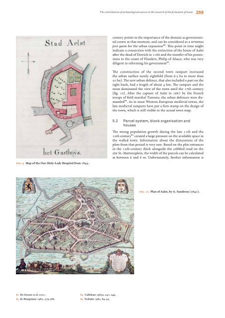
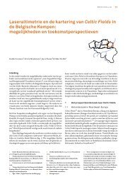
- Page 260 and 261: 260 Koen De Groote lacking. But it
- Page 262 and 263: 262 Koen De Groote 6 Comparison wit
- Page 264 and 265: 264 Koen De Groote Bibliography ber
- Page 266 and 267: 266 Koen De Groote raveschot p. 199
- Page 268 and 269: 268 10 Bartels 1999. Dave H. Evans
- Page 270 and 271: 270 29 Evans 1985. Dave H. Evans In
- Page 272 and 273: 272 Dave H. Evans Th e connection b
- Page 274 and 275: 274 Dave H. Evans remove the privy
- Page 276 and 277: 276 Dave H. Evans Acknowledgements
- Page 278 and 279: 278 Dave H. Evans mccall a. 1979: T
- Page 280 and 281: 280 Wim Hupperetz archaeological da
- Page 282 and 283: 282 Wim Hupperetz Fig. 2 Two handle
- Page 284 and 285: 284 Wim Hupperetz Bibliography bart
- Page 286 and 287: 286 Else Roesdahl church, where the
- Page 288 and 289: 288 Else Roesdahl Bibliography birk
- Page 290 and 291: 290 Dries Tys 10 Verhaeghe 1981; Id
- Page 292 and 293: 292 Dries Tys 4 Coastal estates of
- Page 294 and 295: 294 Dries Tys we look more closely
- Page 296 and 297: 296 Dries Tys draw-bridge49. From t
- Page 298 and 299: 298 56 Idem 1998. Dries Tys happene
- Page 300 and 301: 300 Dries Tys soens t. & tys d. 200
- Page 303 and 304: La dotation funéraire des tombes d
- Page 305 and 306: véritablement germanique16. L’in
- Page 307 and 308: critères est sans doute celle de H
- Page 309 and 310:
désormais couramment. La rareté c
- Page 311 and 312:
La dotation funéraire des tombes d
- Page 313 and 314:
La dotation funéraire des tombes d
- Page 315:
La dotation funéraire des tombes d
- Page 318 and 319:
318 Paul Courtney instead chose to
- Page 320 and 321:
320 Paul Courtney important recent
- Page 322 and 323:
322 93 Idem 1963. Paul Courtney whi
- Page 324 and 325:
324 Paul Courtney and gender relati
- Page 326 and 327:
326 Paul Courtney off access to new
- Page 328 and 329:
328 Paul Courtney bartels m. (ed.)
- Page 330 and 331:
330 Paul Courtney burke p. 1992: Hi
- Page 332 and 333:
332 Paul Courtney de certeau m. 198
- Page 334 and 335:
334 Paul Courtney geertz c. 1973: T
- Page 336 and 337:
336 Paul Courtney ijzereef g. 1987:
- Page 338 and 339:
338 Paul Courtney markus t. a. 1993
- Page 340 and 341:
340 Paul Courtney ó giollain d. 20
- Page 342 and 343:
342 Paul Courtney sereni e. 1967: S
- Page 344 and 345:
344 Paul Courtney van der wee h. 19
- Page 347 and 348:
Bibliography Frans Verhaeghe 1968-2
- Page 349 and 350:
2001 Evans D. & Verhaeghe F.: Brick
- Page 351 and 352:
1995 Dewilde M., Ervynck A., Strobb
- Page 353 and 354:
1990 De Meulemeester J. & Verhaeghe
- Page 355 and 356:
V[erhaeghe] F.: Archeologische inte
- Page 357 and 358:
Hillewaert B. & Verhaeghe F. 1983:
- Page 359 and 360:
De Laet S.J., Van Doorselaer A., De
- Page 361 and 362:
verhaeghe F.: Middeleeuwse bewoning
- Page 363 and 364:
V[erhaeghe] F.: Colloquia en congre
- Page 365 and 366:
V[erhaeghe] F.: Archéologie des Te
- Page 367 and 368:
V[erhaeghe] F.: Tentoonstellingen:
- Page 369 and 370:
V[erhaeghe] F.: Datations C14 et ca
- Page 371 and 372:
1984 V[erhaeghe] F.: Colloquia en c
- Page 373 and 374:
1969 V[an] D[oorselaer] A. & Verhae
- Page 375 and 376:
g.l. Good, R.H. Jones & M.W. Ponsfo
- Page 377 and 378:
H. Beumann & W. Schröder (eds.), D
- Page 379 and 380:
S.E. Van Der Leeuw & A.C. Pritchard
- Page 381 and 382:
O. Olsen & M. Schmidt, Fyrkat. En j
- Page 383 and 384:
Contributors Rica Annaert Vlaams In