Variabilité spatio-temporelle de la chlorophylle en surface de la mer ...
Variabilité spatio-temporelle de la chlorophylle en surface de la mer ...
Variabilité spatio-temporelle de la chlorophylle en surface de la mer ...

You also want an ePaper? Increase the reach of your titles
YUMPU automatically turns print PDFs into web optimized ePapers that Google loves.
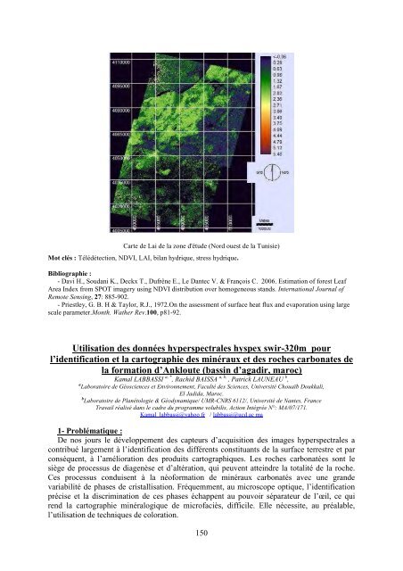
Carte <strong>de</strong> Lai <strong>de</strong> <strong>la</strong> zone d'étu<strong>de</strong> (Nord ouest <strong>de</strong> <strong>la</strong> Tunisie)<br />
Mot clés : Télédétection, NDVI, LAI, bi<strong>la</strong>n hydrique, stress hydrique.<br />
Bibliographie :<br />
- Davi H., Soudani K., Deckx T., Dufrêne E., Le Dantec V. & François C. 2006. Estimation of forest Leaf<br />
Area In<strong>de</strong>x from SPOT imagery using NDVI distribution over homog<strong>en</strong>eous stands. International Journal of<br />
Remote S<strong>en</strong>sing, 27: 885-902.<br />
- Priestley, G. B. H & Taylor, R.J., 1972.On the assessm<strong>en</strong>t of <strong>surface</strong> heat flux and evaporation using <strong>la</strong>rge<br />
scale parameter.Month. Wather Rev.100, p81-92.<br />
Utilisation <strong>de</strong>s données hyperspectrales hyspex swir-320m pour<br />
l’i<strong>de</strong>ntification et <strong>la</strong> cartographie <strong>de</strong>s minéraux et <strong>de</strong>s roches carbonates <strong>de</strong><br />
<strong>la</strong> formation d’Ankloute (bassin d’agadir, maroc)<br />
Kamal LABBASSI a, * , Rachid BAISSA a, b, , Patrick LAUNEAU b ,<br />
a Laboratoire <strong>de</strong> Géosci<strong>en</strong>ces et Environnem<strong>en</strong>t, Faculté <strong>de</strong>s Sci<strong>en</strong>ces, Université Chouaïb Doukkali,<br />
El Jadida, Maroc.<br />
b Laboratoire <strong>de</strong> P<strong>la</strong>nétologie & Géodynamique/ UMR-CNRS 6112/, Université <strong>de</strong> Nantes, France<br />
Travail réalisé dans le cadre du programme volubilis, Action Intégrée N°: MA/07/171.<br />
Kamal <strong>la</strong>bbassi@yahoo fr / <strong>la</strong>bbassi@ucd.ac ma<br />
1- Problématique :<br />
De nos jours le développem<strong>en</strong>t <strong>de</strong>s capteurs d’acquisition <strong>de</strong>s images hyperspectrales a<br />
contribué <strong>la</strong>rgem<strong>en</strong>t à l’i<strong>de</strong>ntification <strong>de</strong>s différ<strong>en</strong>ts constituants <strong>de</strong> <strong>la</strong> <strong>surface</strong> terrestre et par<br />
conséqu<strong>en</strong>t, à l’amélioration <strong>de</strong>s produits cartographiques. Les roches carbonatées sont le<br />
siège <strong>de</strong> processus <strong>de</strong> diag<strong>en</strong>èse et d’altération, qui peuv<strong>en</strong>t atteindre <strong>la</strong> totalité <strong>de</strong> <strong>la</strong> roche.<br />
Ces processus conduis<strong>en</strong>t à <strong>la</strong> néoformation <strong>de</strong> minéraux carbonatés avec une gran<strong>de</strong><br />
variabilité <strong>de</strong> phases <strong>de</strong> cristallisation. Fréquemm<strong>en</strong>t, au microscope optique, l’i<strong>de</strong>ntification<br />
précise et <strong>la</strong> discrimination <strong>de</strong> ces phases échapp<strong>en</strong>t au pouvoir séparateur <strong>de</strong> l’œil, ce qui<br />
r<strong>en</strong>d <strong>la</strong> cartographie minéralogique <strong>de</strong> microfaciès, difficile. Elle nécessite, au préa<strong>la</strong>ble,<br />
l’utilisation <strong>de</strong> techniques <strong>de</strong> coloration.<br />
150