Étude de l'état des lieux de la partie nord du lac Tanganyika dans le ...
Étude de l'état des lieux de la partie nord du lac Tanganyika dans le ...
Étude de l'état des lieux de la partie nord du lac Tanganyika dans le ...
- No tags were found...

You also want an ePaper? Increase the reach of your titles
YUMPU automatically turns print PDFs into web optimized ePapers that Google loves.
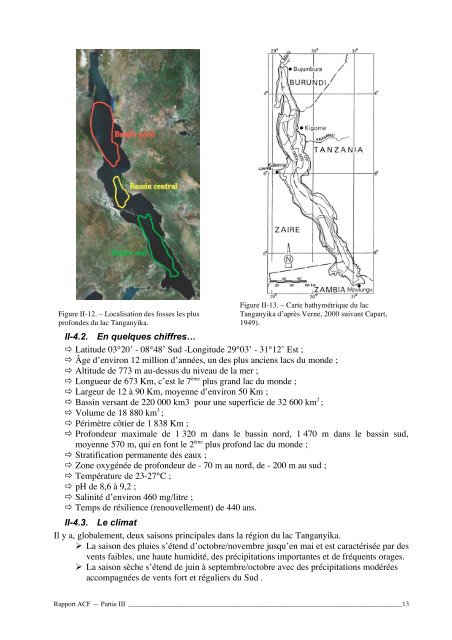
Figure II-12. – Localisation <strong>de</strong>s fosses <strong>le</strong>s plusprofon<strong>de</strong>s <strong>du</strong> <strong>la</strong>c <strong>Tanganyika</strong>.Figure II-13. – Carte bathymétrique <strong>du</strong> <strong>la</strong>c<strong>Tanganyika</strong> d’après Verne, 2000 suivant Capart,1949).II-4.2. En quelques chiffres… Latitu<strong>de</strong> 03°20’ - 08°48’ Sud -Longitu<strong>de</strong> 29°03’ - 31°12’ Est ; Âge d’environ 12 million d’années, un <strong>de</strong>s plus anciens <strong>la</strong>cs <strong>du</strong> mon<strong>de</strong> ; Altitu<strong>de</strong> <strong>de</strong> 773 m au-<strong>de</strong>ssus <strong>du</strong> niveau <strong>de</strong> <strong>la</strong> mer ; Longueur <strong>de</strong> 673 Km, c’est <strong>le</strong> 7 ème plus grand <strong>la</strong>c <strong>du</strong> mon<strong>de</strong> ; Largeur <strong>de</strong> 12 à 90 Km, moyenne d’environ 50 Km ; Bassin versant <strong>de</strong> 220 000 km3 pour une superficie <strong>de</strong> 32 600 km 2 ; Volume <strong>de</strong> 18 880 km 3 ; Périmètre côtier <strong>de</strong> 1 838 Km ; Profon<strong>de</strong>ur maxima<strong>le</strong> <strong>de</strong> 1 320 m <strong>dans</strong> <strong>le</strong> bassin <strong>nord</strong>, 1 470 m <strong>dans</strong> <strong>le</strong> bassin sud,moyenne 570 m, qui en font <strong>le</strong> 2 ème plus profond <strong>la</strong>c <strong>du</strong> mon<strong>de</strong> ; Stratification permanente <strong>de</strong>s eaux ; Zone oxygénée <strong>de</strong> profon<strong>de</strong>ur <strong>de</strong> - 70 m au <strong>nord</strong>, <strong>de</strong> - 200 m au sud ; Température <strong>de</strong> 23-27°C ; pH <strong>de</strong> 8,6 à 9,2 ; Salinité d’environ 460 mg/litre ; Temps <strong>de</strong> résilience (renouvel<strong>le</strong>ment) <strong>de</strong> 440 ans.II-4.3. Le climatIl y a, globa<strong>le</strong>ment, <strong>de</strong>ux saisons principa<strong>le</strong>s <strong>dans</strong> <strong>la</strong> région <strong>du</strong> <strong>la</strong>c <strong>Tanganyika</strong>. La saison <strong>de</strong>s pluies s’étend d’octobre/novembre jusqu’en mai et est caractérisée par <strong>de</strong>svents faib<strong>le</strong>s, une haute humidité, <strong>de</strong>s précipitations importantes et <strong>de</strong> fréquents orages. La saison sèche s’étend <strong>de</strong> juin à septembre/octobre avec <strong>de</strong>s précipitations modéréesaccompagnées <strong>de</strong> vents fort et réguliers <strong>du</strong> Sud .Rapport ACF — Partie III _______________________________________________________________________________13