PORT OF HAMBURG magazine - Hafen Hamburg
PORT OF HAMBURG magazine - Hafen Hamburg
PORT OF HAMBURG magazine - Hafen Hamburg
- Keine Tags gefunden...

Sie wollen auch ein ePaper? Erhöhen Sie die Reichweite Ihrer Titel.
YUMPU macht aus Druck-PDFs automatisch weboptimierte ePaper, die Google liebt.
www.vesseltracker.com<br />
A shipping company employee who<br />
needs to quickly establish the position<br />
of ship belonging to the company; a<br />
harbour pilot wanting to find out how<br />
far out to sea a vessel he needs to<br />
steer safely through his territory still is;<br />
a service provider interested in the<br />
position of a ship even outside working<br />
hours – vesseltracker.com provides a<br />
practical solution for all of them.<br />
The <strong>Hamburg</strong>-based software<br />
architects, who set up shop not<br />
far from the Aussenalster in<br />
the city’s east, are offering a highperformance<br />
tool that impresses not<br />
least because it is just as suitable for<br />
the day-to-day operation of a shipping<br />
company as it is for ship-spotting<br />
enthusiasts. Accordingly, the<br />
different versions of the complex,<br />
yet easy-to-use software are tailored<br />
to suit individual needs. What was<br />
important to the programmers working<br />
with company chief Ralf<br />
Paahsen was that the application<br />
should be web-based, so that users<br />
would not need to install extensive<br />
software systems in order to use the<br />
service. “Stand-alone services are<br />
simply no longer up with the times,“<br />
said Paahsen. “Today it is expected<br />
that users can call up data from any<br />
computer anywhere in the world.”<br />
Since all ships operating today are<br />
equipped with an automatic identification<br />
system – AIS for short – their<br />
journeys can be tracked in real time.<br />
All vessels fitted with AIS transmit<br />
a range of data (call sign, name,<br />
length, width and type of vessel) via<br />
radio link. This data can be received<br />
by AIS receivers and evaluated.<br />
At present, vesseltracker.com operates<br />
mainly in the North-European region,<br />
covering the main ports, such as<br />
<strong>Hamburg</strong>, Bremerhaven, Rotterdam,<br />
Antwerp, Tilbury and Le Havre, as<br />
well as many other ports and regions.<br />
Already vesseltracker operates<br />
just under 50 receiver stations, each<br />
with a range of 30 to 50 miles.<br />
The medium term goal is to achieve<br />
virtually complete coverage of all<br />
major ports throughout Europe.<br />
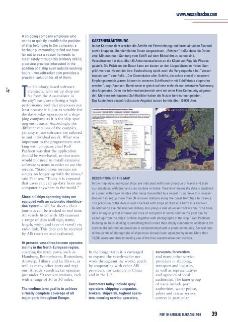
KARTENERLÄUTERUNG<br />
In der Kartenansicht werden die Schiffe mit Fahrtrichtung und ihrem aktuellen Zustand<br />
sowie knappen, übersichtlichen Daten ausgewiesen. „Echtzeit“ heißt, dass die Daten<br />
zwei Minuten nach Sendung vom Schiff auf dem Bildschirm zu sehen sind.<br />
Vesseltracker hat dazu über 30 Antennenstationen an die Küste von Riga bis Piraeus<br />
gestellt. Die Präzision der Daten kann am besten an den Liegeplätzen im <strong>Hafen</strong> überprüft<br />
werden. Neben der Live-Beobachtung spielt auch die Vergangenheit bei “vesseltracker.com”<br />
eine Rolle. „Die Stammdaten aller Schiffe, die schon einmal in unserem<br />
Empfangsbereich waren, können in unserem Schiffsarchiv mit Schiffsfotos abgerufen<br />
werden”, sagt Paahsen. Damit weist er gleich auf eine mehr als nur dekorative Weiterung<br />
des Angebotes. Denn der Informationsbereich wird mit einer Foto-Community abgerundet.<br />
Mehrere zehntausend Schiffsbilder haben die Nutzer bereits hochgeladen.<br />
Das kostenlose vesseltracker.com-Angebot nutzen bereits über 10.000 User.<br />
DESCRIPTION <strong>OF</strong> THE MAP<br />
In the map view, individual ships are indicated with their direction of travel and their<br />
current status, with brief and concise data included. ‘Real time’ means the data is displayed<br />
on screen within two minutes after being transmitted by a vessel. To achieve this, vesseltracker<br />
has set up more than 30 receiver stations along the coast from Riga to Piraeus.<br />
The precision of the data is best checked with ships docked at a berth in a harbour.<br />
In addition to live observation, history also plays a role at vesseltracker.com: “The base<br />
data of any ship that entered our area of reception at some point in the past can be<br />
called up from the ships’ archive, together with photographs of the ship,” said Paahsen.<br />
In doing so, he is alluding to something that is more than simply a decorative addition to the<br />
service: the information provision is complemented with a photo community. Several tens<br />
of thousands of photographs of ships have already been uploaded by users. More than<br />
10,000 users are already making use of the free vesseltracker.com service.<br />
In the longer term it is envisaged<br />
to expand the vesseltracker network<br />
throughout the world, partly<br />
by cooperating with other AIS<br />
providers, for example in China<br />
and in the U.S.<br />
Customers today include quay<br />
operators, shipping companies,<br />
brokers, shipyards, tugboat operators,<br />
mooring service operators,<br />
surveyors, forwarders<br />
and many other service<br />
providers in shipping,<br />
transport and logistics,<br />
as well as representatives<br />
and agencies of local<br />
authorities. The latter group<br />
of users include port<br />
authorities, water police,<br />
pilots and rescue service<br />
centres in particular.<br />
<strong>PORT</strong> <strong>OF</strong> <strong>HAMBURG</strong> MAGAZINE 2/08<br />
39