BASEL-STADT: 4 PRoPoSALS - ETH Basel
BASEL-STADT: 4 PRoPoSALS - ETH Basel
BASEL-STADT: 4 PRoPoSALS - ETH Basel

Create successful ePaper yourself
Turn your PDF publications into a flip-book with our unique Google optimized e-Paper software.
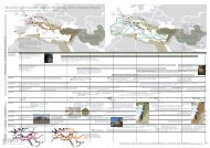
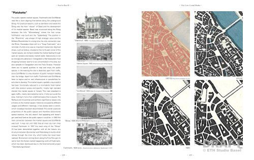
“Platzkette“<br />
The public spaces market square, Fischmarkt and Schifflände<br />
read like a chain aligning themselves along the underground<br />
Birsig. For practical reasons, such as sanitation and waste the<br />
Birsig was the main “vessel“ of <strong>Basel</strong> and the development<br />
of it’s market spaces: <strong>Basel</strong> was structured along the Birsig<br />
between the hills “Münsterberg”, where the first roman<br />
fortification was built and the “Spalenberg“. The position in<br />
the “Rheinknie“ was always of high strategic value and the<br />
Mittlere Rheinbrücke for a long time the only connection over<br />
the Rhine. Nowadays there still is a “Coop Fischmarkt“ as a<br />
reminder of what once was an important market site. Big food<br />
shops, such as Globus, situated at the north-east corner of the<br />
market square, are trying to vitalise the market feeling through<br />
open air vendors and classic market stalls. Gastronomy is not<br />
as strongly articulated as in Claragraben or Barfüsserplatz, food<br />
shopping however seems to be concentrated in the area, but<br />
also spreads to Claragraben and into Freie Strasse. However<br />
there are no spatial qualities to stay and enjoy the public<br />
spaces: in the evening the site is deserted, apart from traffic,<br />
since Schifflände is a key situation of public transport leading<br />
over the bridge. Apart from traffic Fischmarkt and Schifflände<br />
have no topics and no real infrastructure or possibilities for<br />
activities to develop. The market square, spatially unsuccessful<br />
has been functionally reduced to a minimalistic food market<br />
with little product variety and specific, mostly high standard<br />
clientel: the market square is “empty“. The main drawback is<br />
again traffic, mainly dominated by trams, it fully surrounds the<br />
area, making it more of an undefined space than a square. The<br />
Rathaus and it’s political and symbolic significance leaves only<br />
a history to the market square: historicly occupied by different<br />
usages and different meanings, it has always been a centre,<br />
which nowadays has been decentralised. The overall unprecise<br />
proportions of the public spaces and therefore disfunctional<br />
spatial relations, the site doesn’t feel appealing and doesn’t<br />
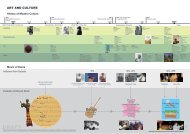
get used and lived as the public space it could be. In 1900 the<br />
tram connection between the market square and Schifflände<br />
was built. It was not until 1903 that all inner city tram lines<br />
crossed Fischmark. In 1937 the west wing of the “Börse“<br />
(3) has been demolished together with all the historic city<br />
structure between Blumenrain and Petersberg to build a strait<br />
railway through the inner city, which luckily has never been<br />
realised. Blumenrain coming down along the Trois Rois got it’s<br />
name from the flower market happening north of Fischmarkt,<br />
which has been destroyed due to the forementioned project<br />
“Talentlastungsstrasse“.<br />
– Food in <strong>Basel</strong> II – – City Core: Central Market –<br />
“Markthof”, 1895 (“Der Basler Arbeitsrappen”, p. 161) (1)<br />
Market Square, 1900 (http://www.g-st.ch/trambasel/)<br />
“Schifflände”, 1905 (http://www.g-st.ch/trambasel/) (2)<br />
“Börse”, 1906 (Bischoff/Weideli) (http://www.g-st.ch/trambasel/) (3)<br />
© Grundbuch und Vermessungsamt | www.gva.bs.ch www.stadtplan.bs.ch<br />
Dieser Planausdruck hat nur informativen Charakter Ausdruck vom 28. März 2012<br />
© <strong>ETH</strong> Studio <strong>Basel</strong><br />
Fischmarkt, 1929 (<strong>BASEL</strong>, Geschichte einer städtischen Gesellschaft, S.237)<br />
– 528 – – 529 –<br />
1857-59 (http://www.stadtplan.bs.ch/) 1872-82<br />
DRAFT<br />
1900 1940