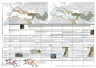
BASEL-STADT: 4 PRoPoSALS - ETH Basel
BASEL-STADT: 4 PRoPoSALS - ETH Basel
BASEL-STADT: 4 PRoPoSALS - ETH Basel

You also want an ePaper? Increase the reach of your titles
YUMPU automatically turns print PDFs into web optimized ePapers that Google loves.
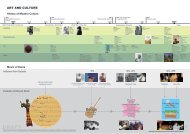
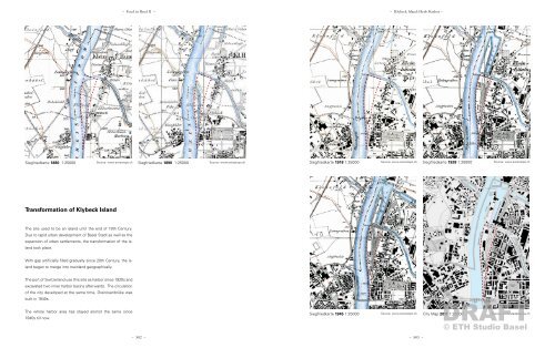
Siegfriedkarte 1880 1:25000<br />
Source: www.swisstopo.ch<br />
Transformation of Klybeck Island<br />
The site used to be an island until the end of 19th Century.<br />
Due to rapid urban development of <strong>Basel</strong> Stadt as well as the<br />
expansion of urban settlements, the transformation of the island<br />
took place.<br />
With gap artificially filled gradually since 20th Century, the island<br />
began to merge into mainland geographically.<br />
The port of Switzerland use this site as harbor since 1920s and<br />
excavated two inner harbor basins afterwards. The circulation<br />
of the city developed at the same time, Dreirosenbrüke was<br />
built in 1940s.<br />
The whole harbor area has stayed alomst the same since<br />
1940s till now.<br />
– Food in <strong>Basel</strong> II – – Klybeck Island: Herb Harbor –<br />
Siegfriedkarte 1890 1:25000<br />
Source: www.swisstopo.ch<br />
Siegfriedkarte 1918 1:25000<br />
Siegfriedkarte 1945 1:25000<br />
Source: www.swisstopo.ch<br />
– 582 – – 583 –<br />
Siegfriedkarte 1928 1:25000<br />
Source: www.swisstopo.ch<br />
DRAFT<br />
Source: www.swisstopo.ch City Map 2011 1:25000<br />
Source: www.stadtplan.bs.ch<br />
© <strong>ETH</strong> Studio <strong>Basel</strong>