Supporting Documentation - Renfrewshire Council
Supporting Documentation - Renfrewshire Council
Supporting Documentation - Renfrewshire Council

Create successful ePaper yourself
Turn your PDF publications into a flip-book with our unique Google optimized e-Paper software.
2. Site Information and Planning Assessment<br />
2.1 Site and Environment<br />
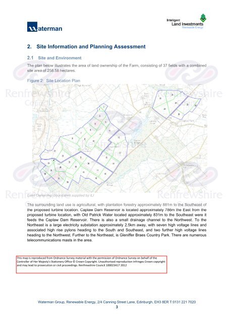
The plan below illustrates the area of land ownership of the Farm, consisting of 37 fields with a combined<br />
site area of 258.58 hectares.<br />
Figure 2: Site Location Plan<br />
Land Ownership Boundaries supplied by ILI<br />
The surrounding land use is agricultural, with plantation forestry approximately 881m to the Southeast of<br />
the proposed turbine location. Caplaw Dam Reservoir is located approximately 786m the East from the<br />
proposed turbine location, with Old Patrick Water located approximately 831m to the Southeast were it<br />
feeds the Caplaw Dam Reservoir. There is also a small drainage channel to the Northwest. To the<br />
Northeast is a large electricity substation approximately 2.5km away, with seven high voltage lines and<br />
associated high rise pylons heading to the South and Southeast, and two further high voltage lines<br />
heading to the Northwest. Further to the Northeast, is Gleniffer Braes Country Park. There are numerous<br />
telecommunications masts in the area.<br />
Waterman Group, Renewable Energy, 2/4 Canning Street Lane, Edinburgh, EH3 8ER T:0131 221 7020<br />
3<br />
K:\Projects\CIV12920_ILI Windfarms_Batch 7\CIV12920_XXX_Hartfield<br />
Farm\Documents\Reports\CIV12920_1202xx_Hartfield_<strong>Supporting</strong> Turbine Assessment_225kW.docx