Supporting Documentation - Renfrewshire Council
Supporting Documentation - Renfrewshire Council
Supporting Documentation - Renfrewshire Council

Create successful ePaper yourself
Turn your PDF publications into a flip-book with our unique Google optimized e-Paper software.
Self assessment maps show that the site;<br />
• Appears to be outwith a Primary Surveillance Radar (PSR) zone<br />
• is in an area of concern with MOD/MET office radar for larger wind farms<br />
• is in an area with no military flying concerns<br />
• appears to fall within a Civil Aviation Aerodrome or Consultation Zone<br />
Maps are also available through NATS EN-Route Plc (NERL), which are designed to aid developers in<br />
understanding where interference with NERL infrastructure is likely. The maps provide guidance and do<br />
not represent no-go areas nor do they represent an exhaustive list of areas which will be affected.<br />
The proposed turbine position is within 15 nautical miles of a Secondary Surveillance Radar (SSR) and it<br />
is within 10km of a Navigation Aids (NAV) consultation zones. Air Traffic Services would carry out a full<br />
in-depth assessment, upon receiving a turbine application. It is outwith10km from an Air Ground Air<br />
(AGA) zone.<br />
In addition, the proposed site with a 45.9m to tip wind turbine on it is not within 10km of an Air-Ground-Air<br />
or Navigation Aid site or within the detection zone of NERL’s Primary Surveillance Radar.<br />
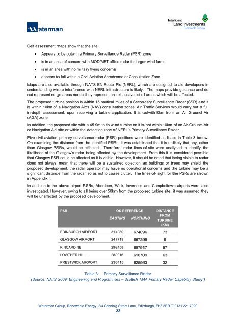
Five civil aviation primary surveillance radar (PSR) positions were identified as listed in Table 3 below.<br />
On examining the distance from the identified PSRs, it was established that it is unlikely that any, other<br />
than Glasgow PSRs, would be affected. Therefore, radar lines-of-site were analysed to identify the<br />
likelihood of the Glasgow’s radar being affected by the development. From this it is considered possible<br />
that Glasgow PSR could be affected as it is visible. However, it should be noted that being visible to radar<br />
does not always mean that there will be a sustained objection as buildings or trees may shield the<br />
proposed development, the radar operator may have no operational concerns and the turbine may be a<br />
significant distance from the radar so as not to cause clutter. The lines-of- sight for the PSRs are shown<br />
in Appendix I.<br />
In addition to the above airport PSRs, Aberdeen, Wick, Inverness and Campbeltown airports were also<br />
investigated. However, owing to all being over 50km from the proposed turbine site, it was assumed they<br />
will be unaffected by the proposed development.<br />
PSR OS REFERENCE DISTANCE<br />
EASTING NORTHING<br />
FROM<br />
TURBINE<br />
(KM)<br />
EDINBURGH AIRPORT 314080 674096 73<br />
GLASGOW AIRPORT 247719 667299 9<br />
KINCARDINE 292458 687947 57<br />
LOWTHER HILL 289016 610709 63<br />
PRESTWICK AIRPORT 236415 625963 32<br />
Table 3: Primary Surveillance Radar<br />
(Source: NATS 2009: Engineering and Programmes – Scottish TMA Primary Radar Capability Study”)<br />
Waterman Group, Renewable Energy, 2/4 Canning Street Lane, Edinburgh, EH3 8ER T:0131 221 7020<br />
22<br />
K:\Projects\CIV12920_ILI Windfarms_Batch 7\CIV12920_XXX_Hartfield<br />
Farm\Documents\Reports\CIV12920_1202xx_Hartfield_<strong>Supporting</strong> Turbine Assessment_225kW.docx