Supporting Documentation - Renfrewshire Council
Supporting Documentation - Renfrewshire Council
Supporting Documentation - Renfrewshire Council

Create successful ePaper yourself
Turn your PDF publications into a flip-book with our unique Google optimized e-Paper software.
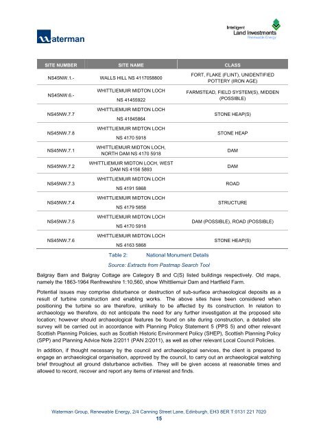
SITE NUMBER SITE NAME CLASS<br />
NS45NW.1.- WALLS HILL NS 4117058800<br />
NS45NW.6.-<br />
NS45NW.7.7<br />
NS45NW.7.8<br />
NS45NW.7.1<br />
NS45NW.7.2<br />
NS45NW.7.3<br />
NS45NW.7.4<br />
NS45NW.7.5<br />
NS45NW.7.6<br />
WHITTLIEMUIR MIDTON LOCH<br />
NS 41455922<br />
WHITTLIEMUIR MIDTON LOCH<br />
NS 41845864<br />
WHITTLIEMUIR MIDTON LOCH<br />
NS 4170 5918<br />
WHITTLIEMUIR MIDTON LOCH,<br />
NORTH DAM NS 4170 5918<br />
WHITTLIEMUIR MIDTON LOCH, WEST<br />
DAM NS 4156 5893<br />
WHITTLIEMUIR MIDTON LOCH<br />
NS 4191 5868<br />
WHITTLIEMUIR MIDTON LOCH<br />
NS 4179 5858<br />
WHITTLIEMUIR MIDTON LOCH<br />
NS 4170 5918<br />
WHITTLIEMUIR MIDTON LOCH<br />
NS 4163 5868<br />
Table 2: National Monument Details<br />
Source: Extracts from Pastmap Search Tool<br />
FORT, FLAKE (FLINT), UNIDENTIFIED<br />
POTTERY (IRON AGE)<br />
FARMSTEAD, FIELD SYSTEM(S), MIDDEN<br />
(POSSIBLE)<br />
STONE HEAP(S)<br />
STONE HEAP<br />
Waterman Group, Renewable Energy, 2/4 Canning Street Lane, Edinburgh, EH3 8ER T:0131 221 7020<br />
15<br />
K:\Projects\CIV12920_ILI Windfarms_Batch 7\CIV12920_XXX_Hartfield<br />
Farm\Documents\Reports\CIV12920_1202xx_Hartfield_<strong>Supporting</strong> Turbine Assessment_225kW.docx<br />
DAM<br />
DAM<br />
ROAD<br />
STRUCTURE<br />
DAM (POSSIBLE), ROAD (POSSIBLE)<br />
STONE HEAP(S)<br />
Balgray Barn and Balgray Cottage are Category B and C(S) listed buildings respectively. Old maps,<br />
namely the 1863-1964 <strong>Renfrewshire</strong> 1:10,560, show Whittliemuir Dam and Hartfield Farm.<br />
Potential issues may comprise disturbance or destruction of sub-surface archaeological deposits as a<br />
result of turbine construction and enabling works. The above sites have been considered when<br />
positioning the turbine so are therefore, unlikely to be affected by its construction. In relation to<br />
archaeology we therefore, do not anticipate the need for any further investigation at the proposed site<br />
location; however should archaeological features be found on site during construction, a detailed site<br />
survey will be carried out in accordance with Planning Policy Statement 5 (PPS 5) and other relevant<br />
Scottish Planning Policies, such as Scottish Historic Environment Policy (SHEP), Scottish Planning Policy<br />
(SPP) and Planning Advice Note 2/2011 (PAN 2/2011), as well as other relevant Local <strong>Council</strong> Policies.<br />
In addition, if thought necessary by the council and archaeological services, the client is prepared to<br />
engage an archaeological organisation, approved by the council, to carry out an archaeological watching<br />
brief throughout all ground disturbance activities. They will be given access at reasonable times and<br />
allowed to record, recover and report any items of interest and finds.