reese creek zoning district regulations and map - Gallatin County ...
reese creek zoning district regulations and map - Gallatin County ...
reese creek zoning district regulations and map - Gallatin County ...
You also want an ePaper? Increase the reach of your titles
YUMPU automatically turns print PDFs into web optimized ePapers that Google loves.
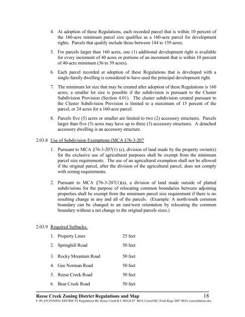
4. At adoption of these Regulations, each recorded parcel that is within 10 percent of<br />
the 160-acre minimum parcel size qualifies as a 160-acre parcel for development<br />
rights. Parcels that qualify include those between 144 to 159 acres.<br />
5. For parcels larger than 160 acres, one (1) additional development right is available<br />
for every increment of 40 acres or portions of an increment that is within 10 percent<br />
of 40-acre minimum (36 to 39 acres).<br />
6. Each parcel recorded at adoption of these Regulations that is developed with a<br />
single-family dwelling is considered to have used the principal development right.<br />
7. The minimum lot size that may be created after adoption of these Regulations is 160<br />
acres; a smaller lot size is possible if the subdivision is pursuant to the Cluster<br />
Subdivision Provision (Section 4.01). The cluster subdivision created pursuant to<br />
the Cluster Subdivision Provision is limited to a maximum of 15 percent of the<br />
parcel, or 24 acres for a 160-acre parcel.<br />
8. Parcels five (5) acres or smaller are limited to two (2) accessory structures. Parcels<br />
larger than five (5) acres may have up to three (3) accessory structures. A detached<br />
accessory dwelling is an accessory structure.<br />
2.03.8 Use of Subdivision Exemptions (MCA §76-3-207<br />
1. Pursuant to MCA §76-3-207(1) (c), division of l<strong>and</strong> made by the property owner(s)<br />
for the exclusive use of agricultural purposes shall be exempt from the minimum<br />
parcel size requirements. The use of an agricultural exemption shall not be allowed<br />
if the original parcel, after the division of the agricultural parcel, does not comply<br />
with <strong>zoning</strong> requirements.<br />
2. Pursuant to MCA §76-3-207(1)(a), a division of l<strong>and</strong> made outside of platted<br />
subdivisions for the purpose of relocating common boundaries between adjoining<br />
properties shall be exempt from the minimum parcel size requirement if there is no<br />
resulting change in any <strong>and</strong> all of the parcels. (Example: A north/south common<br />
boundary can be changed to an east/west orientation by relocating the common<br />
boundary without a net change to the original parcels sizes.)<br />
2.03.9 Required Setbacks.<br />
1. Property Lines 25 feet<br />
2. Springhill Road 50 feet<br />
3. Rocky Mountain Road 50 feet<br />
4. Gee Norman Road 50 feet<br />
5. Reese Creek Road 50 feet<br />
6. Bear Creek Road 50 feet<br />
Reese Creek Zoning District Regulations <strong>and</strong> Map 18<br />
F:\PLAN\ZONING DISTRICTS Regulations\RC.Reese Creek\R.C.REGS.07 BOA Consol\RC.Final.Regs.2007 BOA consolidation.doc


