reese creek zoning district regulations and map - Gallatin County ...
reese creek zoning district regulations and map - Gallatin County ...
reese creek zoning district regulations and map - Gallatin County ...
You also want an ePaper? Increase the reach of your titles
YUMPU automatically turns print PDFs into web optimized ePapers that Google loves.
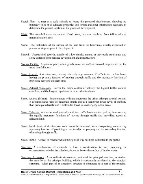
Sketch Plan. A <strong>map</strong> at a scale suitable to locate the proposed development, showing the<br />
boundary lines of all adjacent properties <strong>and</strong> streets <strong>and</strong> other information necessary to<br />
determine the general location of the proposed development.<br />
Slide. The downhill mass movement of soil, rock, or snow resulting from failure of that<br />
material under stress.<br />
Slope. The inclination of the surface of the l<strong>and</strong> from the horizontal, usually expressed in<br />
percent or degrees prior to development.<br />
Sprawl. Uncontrolled growth, usually of a low-density nature, in previously rural areas <strong>and</strong><br />
some distance from existing development <strong>and</strong> infrastructure.<br />
Storage Facility. A space or place where goods, materials <strong>and</strong>/ or personal property are put for<br />
more than 24 hours.<br />
Street, Arterial. A street or road, moving relatively large volumes of traffic in two or four lanes,<br />
having the primary function of moving through traffic <strong>and</strong> the secondary function of<br />
providing access to adjacent l<strong>and</strong>.<br />
Street, Arterial (Principal). Serves the major centers of activity, the highest traffic volume<br />
corridors, <strong>and</strong> the longest trip distances in an urbanized area.<br />
Street, Arterial (Minor). Interconnects with <strong>and</strong> augments the urban principal arterial system.<br />
It accommodates trips of moderate length <strong>and</strong> at a somewhat lower level of mobility<br />
than principal arterials, <strong>and</strong> it distributes travel to smaller geographic areas.<br />
Street, Collector. A street or road generally with two traffic lanes <strong>and</strong> two parking lanes serving<br />
the equally important functions of moving through traffic <strong>and</strong> providing access to<br />
adjacent l<strong>and</strong>.<br />
Street, Local Street. A street or road with two traffic lanes <strong>and</strong> one or two parking lanes having<br />
a primary function of providing access to adjacent property <strong>and</strong> the secondary function<br />
of moving through traffic.<br />
Street, Public. A street or road for which the right-of-way has been dedicated to the public.<br />
Structure. A combination of materials to form a construction for use, occupancy, or<br />
ornamentation whether installed on, above, or below the surface of l<strong>and</strong> or water.<br />
Structure, Accessory. A subordinate structure or portion of the principal structure, located on<br />
the same lot as the principal building, which is customarily incidental to the principal<br />
structure. When part of an accessory structure is connected to a part of the principal<br />
Reese Creek Zoning District Regulations <strong>and</strong> Map 81<br />
F:\PLAN\ZONING DISTRICTS Regulations\RC.Reese Creek\R.C.REGS.07 BOA Consol\RC.Final.Regs.2007 BOA consolidation.doc


