download the full article here - E-International Scientific Research ...
download the full article here - E-International Scientific Research ...
download the full article here - E-International Scientific Research ...

Create successful ePaper yourself
Turn your PDF publications into a flip-book with our unique Google optimized e-Paper software.
E-<strong>International</strong> <strong>Scientific</strong> <strong>Research</strong> Journal<br />
ISSN: 2094-1749 Volume: 3 Issue: 2, 2011<br />
In scalogram modelling approach (Cruz, 1992), an arithmetic operation was combined with <strong>the</strong><br />
corresponding numerical weights for <strong>the</strong> vulnerable factors. To assess <strong>the</strong> combined vulnerability<br />
level a multiple hazard vulnerability map has been carried out through integration and overlaying<br />
of all existing natural hazards vulnerability with in third order subbasins (TOSBs).<br />
Result and Discussion<br />
Geo-informatics<br />
Geo-informatics module consists of GIS mapping for location map, drainage map, drainage order<br />
map, lineament map, structural map, geological map etc. a brief discussion is given as below:<br />
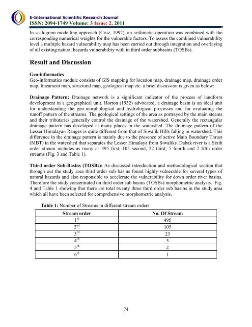
Drainage Pattern: Drainage network is a significant indicator of <strong>the</strong> process of landform<br />
development in a geographical unit. Horton (1932) advocated, a drainage basin is an ideal unit<br />
for understanding <strong>the</strong> geo-morphological and hydrological processes and for evaluating <strong>the</strong><br />
runoff pattern of <strong>the</strong> streams. The geological settings of <strong>the</strong> area as portrayed by <strong>the</strong> main steams<br />
and <strong>the</strong>ir tributaries generally control <strong>the</strong> drainage of <strong>the</strong> watershed. Generally <strong>the</strong> rectangular<br />
drainage pattern has developed at many places in <strong>the</strong> watershed. The drainage pattern of <strong>the</strong><br />
Lesser Himalayan Ranges is quite different from that of Siwalik Hills falling in watershed. This<br />
difference in <strong>the</strong> drainage pattern is mainly due to <strong>the</strong> presence of active Main Boundary Thrust<br />
(MBT) in <strong>the</strong> watershed that separates <strong>the</strong> Lesser Himalaya from Siwaliks. Dabak river is a Sixth<br />
order stream includes as many as 495 first, 105 second, 22 third, 5 fourth and 2 fifth order<br />
streams (Fig. 3 and Table 1).<br />
Third order Sub-Basins (TOSBs): As discussed introduction and methodological section that<br />
through out <strong>the</strong> study area third order sub basins found highly vulnerable for several types of<br />
natural hazards and also responsible to accelerate <strong>the</strong> vulnerability for down order river basins.<br />
T<strong>here</strong>fore <strong>the</strong> study concentrated on third order sub basins (TOSBs) morphometric analysis. Fig.<br />
4 and Table 1 showing that <strong>the</strong>re are total twenty three third order sub basins in <strong>the</strong> study area<br />
which all have been selected for comprehensive morphometric analysis.<br />
Table 1: Number of Streams in different stream orders<br />
Stream order<br />
No. Of Stream<br />
1 st 495<br />
2 nd 105<br />
3 rd 23<br />
4 th 5<br />
5 th 2<br />
6 th 1<br />
74