

JPATS Weather - NETC
JPATS Weather - NETC
JPATS Weather - NETC

Create successful ePaper yourself
Turn your PDF publications into a flip-book with our unique Google optimized e-Paper software.
<strong>JPATS</strong> AVIATION WEATHER BOOKLET<br />
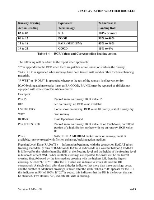
Runway Braking<br />
Action Reading<br />
Equivalent<br />
Terminology<br />
% Increase in<br />
Landing Roll<br />
02 to 05 NIL 100% or more<br />
06 to 12 POOR 99% to 46%<br />
13 to 18 FAIR (MEDIUM) 45% to 16%<br />
19 to 25 GOOD 15% to 0%<br />
Table 6-4 — RCR Values and Corresponding Braking Action<br />
The following will be added to the report when applicable:<br />
“P” is appended to the RCR when there are patches of ice, snow, or slush on the runway.<br />
“SANDED” is appended when runways have been treated with sand or other friction enhancing<br />
materials.<br />
“P WET” or “P DRY” is appended whenever the rest of the runway is either wet or dry.<br />
ICAO braking action remarks (such as BA GOOD, BA NIL) may be reported at airfields not<br />
equipped with decelerometers when required.<br />
Examples:<br />
PSR15 Packed snow on runway, RCR value 15<br />
IR//<br />
Ice on runway, no RCR value available<br />
LSR08P DRY<br />
Loose snow on runway, RCR value 08 patchy, rest of runway dry<br />
WR//<br />
Wet runway<br />
RCRNR<br />
Base Operations closed<br />
PSR12 HFS IR08 Packed snow on runway, RCR value 12 on touchdown, on rollout<br />
portion of a high friction surface with ice on runway, RCR value<br />
08<br />
PSR//<br />
SANDED BA MEDIUM Packed snow on runway, no RCR<br />
available, runway treated with friction enhancer, braking action medium<br />
Freezing Level Data (RADATS) — Information beginning with the contraction RADAT gives<br />
freezing level data. (Think of RAdiosonde DATa. A radiosonde is a weather balloon.) RADAT<br />
is followed by the relative humidity (RH) at the freezing level and the height of the freezing level<br />
in hundreds of feet MSL. When multiple crossings are reported, the order will be the lowest<br />
crossing first, followed by the intermediate crossing with the highest RH, then the highest<br />
crossing. A letter “L” or “H” after the RH value will indicate to which altitude the RH<br />
corresponds. A single slash after these altitudes indicates that more than three crossings occur,<br />
and the number of additional crossings is noted after the slash. When a “00” appears for the RH,<br />
this indicates an RH of 100%. If “20” is coded, this indicates that the RH is the lowest that can<br />
be obtained. Two slashes, “//”, indicate RH data is missing.<br />
Version 3.2/Dec 08 6-13


