

JPATS Weather - NETC
JPATS Weather - NETC
JPATS Weather - NETC

You also want an ePaper? Increase the reach of your titles
YUMPU automatically turns print PDFs into web optimized ePapers that Google loves.
<strong>JPATS</strong> AVIATION WEATHER BOOKLET<br />
Jet Stream Turbulence<br />
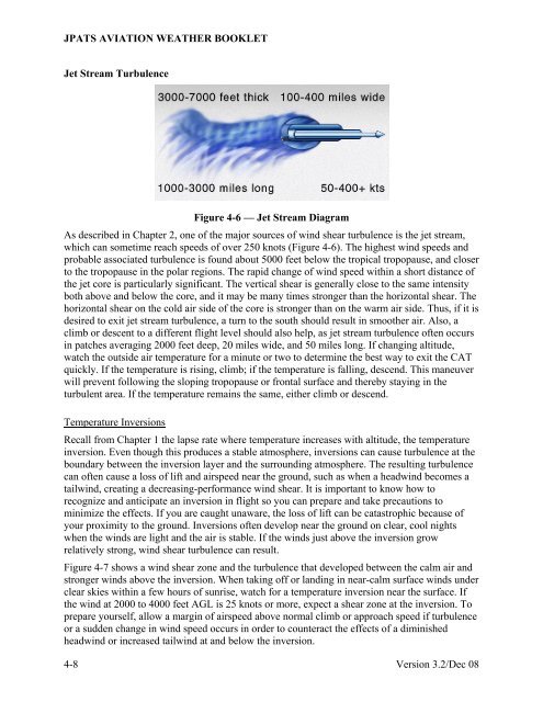
Figure 4-6 — Jet Stream Diagram<br />
As described in Chapter 2, one of the major sources of wind shear turbulence is the jet stream,<br />
which can sometime reach speeds of over 250 knots (Figure 4-6). The highest wind speeds and<br />
probable associated turbulence is found about 5000 feet below the tropical tropopause, and closer<br />
to the tropopause in the polar regions. The rapid change of wind speed within a short distance of<br />
the jet core is particularly significant. The vertical shear is generally close to the same intensity<br />
both above and below the core, and it may be many times stronger than the horizontal shear. The<br />
horizontal shear on the cold air side of the core is stronger than on the warm air side. Thus, if it is<br />
desired to exit jet stream turbulence, a turn to the south should result in smoother air. Also, a<br />
climb or descent to a different flight level should also help, as jet stream turbulence often occurs<br />
in patches averaging 2000 feet deep, 20 miles wide, and 50 miles long. If changing altitude,<br />
watch the outside air temperature for a minute or two to determine the best way to exit the CAT<br />
quickly. If the temperature is rising, climb; if the temperature is falling, descend. This maneuver<br />
will prevent following the sloping tropopause or frontal surface and thereby staying in the<br />
turbulent area. If the temperature remains the same, either climb or descend.<br />
Temperature Inversions<br />
Recall from Chapter 1 the lapse rate where temperature increases with altitude, the temperature<br />
inversion. Even though this produces a stable atmosphere, inversions can cause turbulence at the<br />
boundary between the inversion layer and the surrounding atmosphere. The resulting turbulence<br />
can often cause a loss of lift and airspeed near the ground, such as when a headwind becomes a<br />
tailwind, creating a decreasing-performance wind shear. It is important to know how to<br />
recognize and anticipate an inversion in flight so you can prepare and take precautions to<br />
minimize the effects. If you are caught unaware, the loss of lift can be catastrophic because of<br />
your proximity to the ground. Inversions often develop near the ground on clear, cool nights<br />
when the winds are light and the air is stable. If the winds just above the inversion grow<br />
relatively strong, wind shear turbulence can result.<br />
Figure 4-7 shows a wind shear zone and the turbulence that developed between the calm air and<br />
stronger winds above the inversion. When taking off or landing in near-calm surface winds under<br />
clear skies within a few hours of sunrise, watch for a temperature inversion near the surface. If<br />
the wind at 2000 to 4000 feet AGL is 25 knots or more, expect a shear zone at the inversion. To<br />
prepare yourself, allow a margin of airspeed above normal climb or approach speed if turbulence<br />
or a sudden change in wind speed occurs in order to counteract the effects of a diminished<br />
headwind or increased tailwind at and below the inversion.<br />
4-8 Version 3.2/Dec 08


