

JPATS Weather - NETC
JPATS Weather - NETC
JPATS Weather - NETC

Create successful ePaper yourself
Turn your PDF publications into a flip-book with our unique Google optimized e-Paper software.
<strong>JPATS</strong> AVIATION WEATHER BOOKLET<br />
Air masses are named according to their moisture content, location, and temperature. The<br />
location of an air mass has a large influence over the other two properties. Naturally, moist air<br />
masses will have a greater potential for producing clouds and precipitation than dry air masses.<br />
Most importantly, though, its temperature indicates the stability of the air mass. Warm air masses<br />
bring stable conditions, while cold air masses are inherently unstable.<br />
Frontal Systems<br />
A front is an area of discontinuity that forms between two contrasting air masses when they are<br />
adjacent to each other. A front can be thought of as a border, boundary, or line between the air<br />
masses. These air masses must have sufficiently different temperature and moisture properties–<br />
the defining characteristics of an air mass–otherwise there would be little reason to distinguish<br />
between them. Since air masses cover many thousands of square miles, the boundary between<br />
them can be hundreds of miles long. As air masses are three-dimensional, fronts are, as well. The<br />
point where a front comes in contact with the ground is called the surface front. The surface front<br />
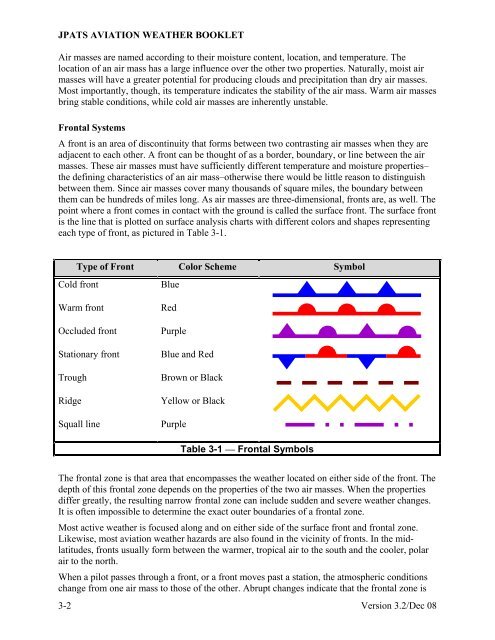
is the line that is plotted on surface analysis charts with different colors and shapes representing<br />
each type of front, as pictured in Table 3-1.<br />
Type of Front Color Scheme Symbol<br />
Cold front<br />
Warm front<br />
Occluded front<br />
Stationary front<br />
Trough<br />
Ridge<br />
Squall line<br />
Blue<br />
Red<br />
Purple<br />
Blue and Red<br />
Brown or Black<br />
Yellow or Black<br />
Purple<br />
Table 3-1 — Frontal Symbols<br />
The frontal zone is that area that encompasses the weather located on either side of the front. The<br />
depth of this frontal zone depends on the properties of the two air masses. When the properties<br />
differ greatly, the resulting narrow frontal zone can include sudden and severe weather changes.<br />
It is often impossible to determine the exact outer boundaries of a frontal zone.<br />
Most active weather is focused along and on either side of the surface front and frontal zone.<br />
Likewise, most aviation weather hazards are also found in the vicinity of fronts. In the midlatitudes,<br />
fronts usually form between the warmer, tropical air to the south and the cooler, polar<br />
air to the north.<br />
When a pilot passes through a front, or a front moves past a station, the atmospheric conditions<br />
change from one air mass to those of the other. Abrupt changes indicate that the frontal zone is<br />
3-2 Version 3.2/Dec 08


