

JPATS Weather - NETC
JPATS Weather - NETC
JPATS Weather - NETC

Create successful ePaper yourself
Turn your PDF publications into a flip-book with our unique Google optimized e-Paper software.
<strong>JPATS</strong> AVIATION WEATHER BOOKLET<br />
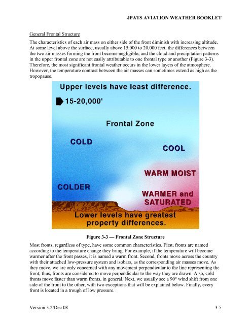
General Frontal Structure<br />
The characteristics of each air mass on either side of the front diminish with increasing altitude.<br />
At some level above the surface, usually above 15,000 to 20,000 feet, the differences between<br />
the two air masses forming the front become negligible, and the cloud and precipitation patterns<br />
in the upper frontal zone are not easily attributable to one frontal type or another (Figure 3-3).<br />
Therefore, the most significant frontal weather occurs in the lower layers of the atmosphere.<br />
However, the temperature contrast between the air masses can sometimes extend as high as the<br />
tropopause.<br />
Figure 3-3 — Frontal Zone Structure<br />
Most fronts, regardless of type, have some common characteristics. First, fronts are named<br />
according to the temperature change they bring. For example, if the temperature will become<br />
warmer after the front passes, it is named a warm front. Second, fronts move across the country<br />
with their attached low-pressure system and isobars, as the corresponding air masses move. As<br />
they move, we are only concerned with any movement perpendicular to the line representing the<br />
front; thus, fronts are considered to move perpendicular to the way they are drawn. Also, cold<br />
fronts move faster than warm fronts, in general. Next, we usually see a 90° wind shift from one<br />
side of the front to the other, with two exceptions that will be explained below. Finally, every<br />
front is located in a trough of low pressure.<br />
Version 3.2/Dec 08 3-5


