

JPATS Weather - NETC
JPATS Weather - NETC
JPATS Weather - NETC

Create successful ePaper yourself
Turn your PDF publications into a flip-book with our unique Google optimized e-Paper software.
<strong>JPATS</strong> AVIATION WEATHER BOOKLET<br />
The slope is the ratio of the vertical rise to horizontal distance. The slope of a warm front is<br />
generally shallow, while the slope of a cold front can be quite steep (Figure 3-7). Shallow frontal<br />
slopes tend to produce extensive cloudiness with large areas of steady precipitation, while steep<br />
frontal slopes tend to move rapidly producing narrow bands of cloudiness and showery<br />
precipitation. Steep frontal slopes normally separate air masses of vastly different properties,<br />
indicating the potential for more severe weather.<br />
The speed of the frontal movement affects the weather associated with it. Faster moving fronts<br />
are generally accompanied by a narrow band of more severe weather. On the other hand, slower<br />
moving fronts have less severe weather, but the frontal zone is more extensive.<br />
COLD FRONTS<br />
The greater the contrast in temperature and moisture between the colliding air masses, the greater<br />
the possibility of weather associated with a front, particularly severe weather. For example, most<br />
tornadoes occur in the spring due to very cold, dry air from Canada colliding with very warm,<br />
moist air from the Gulf of Mexico.<br />
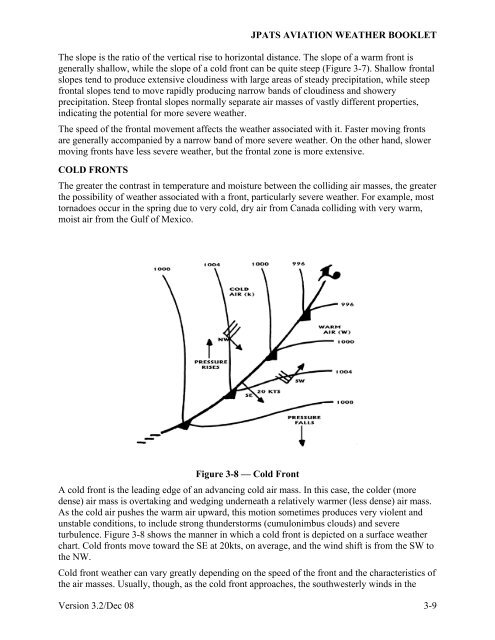
Figure 3-8 — Cold Front<br />
A cold front is the leading edge of an advancing cold air mass. In this case, the colder (more<br />
dense) air mass is overtaking and wedging underneath a relatively warmer (less dense) air mass.<br />
As the cold air pushes the warm air upward, this motion sometimes produces very violent and<br />
unstable conditions, to include strong thunderstorms (cumulonimbus clouds) and severe<br />
turbulence. Figure 3-8 shows the manner in which a cold front is depicted on a surface weather<br />
chart. Cold fronts move toward the SE at 20kts, on average, and the wind shift is from the SW to<br />
the NW.<br />
Cold front weather can vary greatly depending on the speed of the front and the characteristics of<br />
the air masses. Usually, though, as the cold front approaches, the southwesterly winds in the<br />
Version 3.2/Dec 08 3-9


