- Page 1:
& InAsociationwith: Lima&Asociates
- Page 5 and 6:
TABLE OF CONTENTS Page 1. INTRODUCT
- Page 7 and 8:
TABLE OF CONTENTS (Continued) Page
- Page 9 and 10:
TABLE OF CONTENTS (Continued) Page
- Page 11 and 12:
7. INVESTMENT OPTIONS 7-1 7.1 SUMMA
- Page 13 and 14:
LIST OF EXHIBITS Page Exhibit 1-1 S
- Page 15 and 16:
LIST OF EXHIBITS (Continued) Page E
- Page 17 and 18:
LIST OF EXHIBITS (Continued) Page E
- Page 19 and 20:
1. INTRODUCTION 1.1 PROJECT BACKGRO
- Page 21 and 22:
1.3.2 Objectives The primary object
- Page 23 and 24:
2. STUDIES, CONTACTS AND ISSUES Thi
- Page 25 and 26:
Exhibit 2-1 LIST OF STUDY DOCUMENTS
- Page 27 and 28:
2.1.6 Final Project Assessment, SR
- Page 29 and 30:
Intersection Spacing, Location, and
- Page 31 and 32:
lane and the northbound acceleratio
- Page 33 and 34:
amended Regional Transportation Pla
- Page 35 and 36:
• Park-and-Ride Lots with bike lo
- Page 37 and 38:
2.5 TOWN OF ORO VALLEY PLANNING DOC
- Page 39 and 40:
• A Feasibility Study was complet
- Page 41 and 42:
Recommendations for the Calle Conco
- Page 43 and 44:
• A near term transit development
- Page 45 and 46:
• The Miracle Mile to Fort Lowell
- Page 47 and 48:
unmarked crosswalks. Quarter mile p
- Page 49 and 50:
2.8.6 Pinal County Issues raised at
- Page 51:
enough shoulders, and feasibility f
- Page 54 and 55:
Exhibit 3-2 FUTURE POPULATION PROJE
- Page 56 and 57:
La Cholla Blvd La Canada Dr Exhibit
- Page 58 and 59:
La Cholla Blvd La Canada Dr Exhibit
- Page 60 and 61:
Exhibit 3-8 AGE, DISABLED, AND LOW-
- Page 63 and 64:
4. PHYSICAL AND NATURAL ENVIRONMENT
- Page 65 and 66:
Biotic Community Arizona Upland Son
- Page 67 and 68:
Exhibit 4-4 ARIZONA GAME AND FISH D
- Page 69 and 70:
The statutory goal of the Tucson AM
- Page 71 and 72:
Exhibit 4-6 DRAINAGES AND RIPARIAN
- Page 73 and 74:
Exhibit 4-6 DRAINAGE AND RIPARIAN A
- Page 75 and 76:
United States.” The phrase “wat
- Page 77 and 78:
vehicle miles traveled (VMT). On Ap
- Page 79 and 80:
An archaeological survey is recomme
- Page 81 and 82:
Exhibit 4-9 PUBLIC SCHOOLS WITHIN T
- Page 83 and 84:
5. EXISTING TRANSPORTATION FACILITI
- Page 85 and 86:
Exhibit 5-2 CROSS SECTION GEOMETRY
- Page 87 and 88:
Exhibit 5-4 TYPICAL RIGHT-OF-WAY WI
- Page 89 and 90:
Exhibit 5-5 PAVEMENT TYPE ON SR 77
- Page 91 and 92:
Structure Number Structure Name 236
- Page 93 and 94:
(Watershed 1 - Watershed 5, excludi
- Page 95 and 96:
FEMA Flood Insurance Study Exhibit
- Page 97 and 98:
Thornydale Rd Shannon Dr La Canada
- Page 99 and 100: Exhibit 5-13 YEAR 1992, 2002 AND FO
- Page 101 and 102: Exhibit 5-15 YEAR 2002 LEVELS OF CO
- Page 103 and 104: except for the first segment listed
- Page 105 and 106: • In general, as the number of ac
- Page 107 and 108: Exhibit 5-20 SUN TRAN LEVEL OF SERV
- Page 109 and 110: 5.3 INTERMODAL FACILITIES The exten
- Page 111 and 112: Exhibit 5-22 LOCATIONS OF SIDEWALKS
- Page 113 and 114: 5.6 ITS FACILITIES 5.6.1 Traffic Si
- Page 115 and 116: Exhibit 5-25 SR 77/ORACLE ROAD ALRE
- Page 117 and 118: Exhibit 5-26 CORRIDOR NORTH/SOUTH A
- Page 119 and 120: Exhibit 5-27 CORRIDOR EAST/WEST ROA
- Page 121 and 122: East/West Capacity Projects Signifi
- Page 123: Exhibit 5-30 PLANNED AND PROGRAMMED
- Page 126 and 127: The existing and forecast levels of
- Page 128 and 129: Exhibit 6-3 CORRIDOR CONGESTION DEF
- Page 130 and 131: Thornydale Rd La Canada Dr Wells Rd
- Page 132 and 133: The realignment alternative selecte
- Page 134 and 135: Exhibit 6-7 SEGMENTS FOR POSSIBLE L
- Page 136 and 137: Exhibit 6-10 LOCATION OF LEVEL 1 AN
- Page 138 and 139: • A need exists for a grade-separ
- Page 140 and 141: In addition, key stakeholders ident
- Page 142 and 143: 6.4.1 Open House Comments on Pedest
- Page 144 and 145: Project Assessment Begin MP End MP
- Page 146 and 147: Exhibit 6-16 ITS DEFICIENCIES SR 77
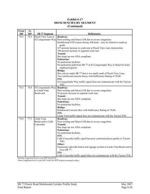
- Page 148 and 149: Exhibit 6-17 DEFICIENCIES BY SEGMEN
- Page 152 and 153: Exhibit 6-17 DEFICIENCIES BY SEGMEN
- Page 154 and 155: Exhibit 6-17 DEFICIENCIES BY SEGMEN
- Page 156 and 157: provide little congestion relief al
- Page 158 and 159: Exhibit 7-2 SUMMARY OF ROADWAY CAPA
- Page 160 and 161: Exhibit 7-3 PORTION OF THE SR 77 CO
- Page 162 and 163: 7. The assumption of an eight-lane
- Page 164 and 165: The fringe urban section might incl
- Page 166 and 167: area of this segment, from Rancho V
- Page 168 and 169: Exhibit 7-6 SUMMARY OF POTENTIALLY
- Page 170 and 171: Exhibit 7-7 SEGMENTS FOR POSSIBLE L
- Page 172 and 173: The proposed recommendations for bi
- Page 174 and 175: Exhibit 7-9 CONSOLIDATION OF WORKSH
- Page 176 and 177: Exhibit 7-11 BRIDGES WITH SUFFICIEN
- Page 178 and 179: Exhibit 7-12 ITS IMPROVEMENTS SR 77
- Page 180 and 181: Segment I-10 to Oracle Road 1.4 Urb
- Page 183 and 184: 8. OPPORTUNITIES AND CONSTRAINTS Th
- Page 185 and 186: Exhibit 8-2 GENERAL OPPORTUNITIES O
- Page 187 and 188: The impacts to existing businesses,
- Page 189 and 190: Exhibit 8-5 PYGMY OWL SURVEY ZONES
- Page 191 and 192: equire special consideration. In ad
- Page 193 and 194: 8.3.7 Pusch Ridge Wilderness Area T
- Page 195: alternative would be a new bridge o
- Page 198 and 199: The capacity and level of service a
- Page 200 and 201:
Exhibit 9-1 LIST OF PROPOSED PROJEC
- Page 202 and 203:
Number Milepost Location SR 77 Defi
- Page 204 and 205:
Exhibit 9-2 COST ESTIMATES FOR CONS
- Page 207 and 208:
10. PUBLIC INVOLVEMENT The public i
- Page 209 and 210:
Exhibit 10-2 OVERVIEW OF SURVEY RES
- Page 211 and 212:
Exhibit 10-3 OVERVIEW OF SURVEY RES
- Page 213 and 214:
Exhibit 10-4 ANALYSIS OF FIRST TRAN
- Page 215 and 216:
Prior to the tour, the project team
- Page 217 and 218:
There was a question about whether
- Page 219 and 220:
Exhibit 10-5 PUBLIC COMMENTS SUBMIT
- Page 221 and 222:
Exhibit 10-7 PUBLIC COMMENTS SUBMIT
- Page 223 and 224:
Exhibit 10-8 (Continued) COMMENTS F
- Page 225 and 226:
Exhibit 10-9 (continued) COMMENTS P
- Page 227:
APPENDIX A Properties Listed on the
- Page 230 and 231:
NRHP Properties within the Study Ar
- Page 233 and 234:
Previous Archaeological Surveys wit
- Page 235 and 236:
Previous Archaeological Surveys wit
- Page 237 and 238:
Previous Archaeological Surveys wit
- Page 239 and 240:
Previous Archaeological Surveys wit
- Page 241 and 242:
Previous Archaeological Surveys wit
- Page 243 and 244:
Previous Archaeological Surveys wit
- Page 245 and 246:
Brew, Susan A. 1979 Letter Report t
- Page 247 and 248:
2001d Cultural Resources Survey of
- Page 249 and 250:
Goldstein, Beau J. 2001 A Cultural
- Page 251 and 252:
1998e A Cultural Resource Inventory
- Page 253 and 254:
2001c Cultural Resources Survey of
- Page 255 and 256:
1986a Letter Report to the State La
- Page 257 and 258:
Roth, Barbara J. 1993 Letter Report
- Page 259 and 260:
1996a Coronado Ridge Right of Way (
- Page 261 and 262:
1980b Clearinghouse Report No. 80-8
- Page 263:
1996 Cultural Resource Survey of Mi
- Page 269:
APPENDIX D Corridor Crash Character
- Page 272 and 273:
SIGNALIZED INTERSECTION NUMBER OF C
- Page 274 and 275:
Mile Post SIGNALIZED INTERSECTION C
- Page 276 and 277:
ROADWAY SEGMENT NUMBER OF CRASHES B
- Page 278 and 279:
Beginning Mile Post Roadway Segment
- Page 280 and 281:
ACCESS RELATED CRASH ANALYSIS SOUTH
- Page 282 and 283:
180 160 140 120 100 80 60 40 20 0 S
- Page 284 and 285:
ACCESS RELATED CRASH ANALYSIS THREE
- Page 286 and 287:
2.15 2.42 3.88 4.80 5.20 5.63 5.88
- Page 289:
NIGHT/DAY CRASH AND ROADWAY LIGHTIN